
| TIOGA MUNI TIOGA ND |
| |
| Lat: N 4822.8 Long: W 10253.8 Elev: 2271 Var: -08 Longest Runway: 5102 | ||
| AWOS: 118.57 CTAF: 122.9 | ||
| ||||||||||||||||||||||||||||||||||||||||||||
| ||||||||||||||||||||||||||||||||||||||||||||
| ||||||||||||||||||||||||||||||||||||||||||||
| FBOs at nearby airports who want your business: | |||||||||||
| |||||||||||
| Rwy | Rwy | |||||||
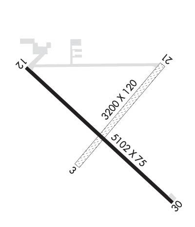
| 3200x120 | 3200' | 3200x120 | 3200' | |||||
| 5102x75 | 5102' | 5102x75 | 5102' | |||||
| Runway ID | Single Wheel | Double Wheel | Double Tandem Wheel | Dual Double Wheel |
| 03/21 | N/A | N/A | N/A | N/A |
| 12/30 | 25,000 | N/A | N/A | N/A |
| These numbers are Advisory and are not limits. The Airport Manager should have more accurate Weight Limits | ||||
 Airport Diagram might not be current. | |
| Facility Name: | TIOGA MUNI |
| City Name: | TIOGA |
| County: | WILLIAMS |
| State abbrev: | ND |
| State Name: | NORTH DAKOTA |
| Ownership: | PUBLICLY OWNED |
| Use: | OPEN TO THE PUBLIC |
| Owner's Name: | TIOGA ARPT AUTHORITY; CURTIS VANDESANT APT CHR; 701-818-8720 |
| Address: | 2237 AVIATOR WAY |
| TIOGA, ND 58852-0428 | |
| Owner's Phone: | 701-664-2343 |
| Manager's Name: | JEFFERY MOE JR. |
| Address: | P.O. BOX 428 |
| TIOGA, ND 58852 | |
| Phone: | 701-216-0036; ARPT MGR ADDL PHONE 701-664-5161. ALTERNATE CONTACT IS STEVE JENSEN - 701-641-3417 |
| FAA Region: | GREAT LAKES |
| FAA Field Office: | DMA |
| Date | Sunrise | Sunset |
|---|---|---|
| 04/25/24 Thursday | 6:41 | 20:58 |
| 04/26/24 Friday | 6:40 | 21:00 |
| 04/27/24 Saturday | 6:38 | 21:01 |
| 04/28/24 Sunday | 6:36 | 21:03 |
| 04/29/24 Monday | 6:34 | 21:04 |
| 04/30/24 Tuesday | 6:33 | 21:06 |
| 05/01/24 Wednesday | 6:31 | 21:07 |
| 05/02/24 Thursday | 6:29 | 21:08 |
| 05/03/24 Friday | 6:28 | 21:10 |
| 05/04/24 Saturday | 6:26 | 21:11 |
| 05/05/24 Sunday | 6:25 | 21:13 |
| 05/06/24 Monday | 6:23 | 21:14 |
| 05/07/24 Tuesday | 6:22 | 21:15 |
| 05/08/24 Wednesday | 6:20 | 21:17 |
| Airport Attendance Schedule | 7 Days A Week 0700-1700; ARPT SERS PHONE TIOGA AERO 701-641-6020 OR 507-649-0831 ON CALL AFT HRS. |
| Airport Status | OPERATIONAL (This Status can change at any time - please check NOTAMS) |
| Airport Lighting Schedule | RY 12/30 MIRL PRESET LOW INTSTY; TO INCR INTST ACTVT PAPI RYS 12 & 30 - CTAF. |
| Airport Storage Available | Tie Downs, Hanger |
| Extra Services Available | Crop Dusting |
| Wind Indicator | YES - (lighted) |
| Control Tower | NO |
| CTAF Frequency | 122.900 |
| Unicom Frequency | |
| Rotating Beacon Color | WG |
| Segmented Circle | YES |
| Landing Fee | NO |
| Airport Inspected | STATE - performed by STATE AERONAUTICAL PERSONNEL |
| Inspection Date | 07/06/2022 |
| Type of Fuel Available | Grade 100LL, JET A (freeze point -40C); -10FUEL SELF SVC 24 HR CREDIT CARD ACCESS. FULL SVC PER ATTENDANT SKED AND ON CALL AFT HRS. |
| Airframe Repair Service | MAJOR; MECHANIC AVBL ON CALL. CTC FBO AT 701-664-3012. |
| Power Plant Repair Service | MAJOR; MECHANIC AVBL ON CALL. CONTACT FBO AT 701-664-3012. |
| Latitude | N4822.8 |
| Longitude | W10253.8 (ESTIMATED) |
| Arpt Elevation | 2270ft (SURVEYED) |
| Magnetic Variation | 08E |
| 2 miles SE | of TIOGA |
| Traffic Pattern Altitude | |
| Sectional Chart | BILLINGS |
| Operations (Reported) | Yearly | Avg. Daily |
|---|---|---|
| General Aviation Transient | 2500 | 7 |
| General Aviation Local | 3000 | 8 |
| Air Taxi | 800 | 2 |
| Commerical | 0 | 0 |
| Commuter | 0 | 0 |
| Military | 40 | 0 |
| Aircraft based on Field | |
|---|---|
| General Aviation Singles | 38 |
| General Aviation Multi | 2 |
| Jet Aircraft | 0 |
| General Aviation Helicopters | 2 |
| Military Aircraft | 0 |
| Gliders | 0 |
| Ultralights | 0 |
| FSS on field | NO |
| FSS tie-in | GRAND FORKS |
| FSS Phone | 1-800-WX-BRIEF |
| Who issues Notams | GFK |
| Notam D service at airport | YES |
| ARTCC Name | MINNEAPOLIS |
| Airport Certification | |
| Aircraft Rescue & Firefighting Index | None |
| Airport of Entry | No |
| Custom Landing Rights | No |
| Joint Civil/Military | No |
| Military Landing rights | YES |
| NATIONAL PLAN OF INTEGRATED AIRPORT SYSTEMS (NPIAS) |
| GRANT AGREEMENTS UNDER FAAP/ADAP/AIP |
| ASSURANCES PURSUANT TO TITLE VI, CIVIL RIGHTS ACT OF 1964 |
| NUMEROUS TOWERS APRX 2 MILES NORTH, SOUTH AND WEST OF ARPT (+236' TWR, 10,500' WEST OF RWY 12/30; +330' TOWER, 13500' SOUTH & WEST OF RWY; +612' TWR 3 MILES SOUTH & WEST OF RWY). |
| CONFIRM SNOW REMOVAL WITH AMGR OR FBO AFTER MAJOR STORM. |
| BIRDS & DEER ON & INVOF ARPT. |
| FOR CD CTC MINNEAPOLIS ARTCC AT 651-463-5588. |
Airport Communications & Frequencies:
| |||||||
| Runway: 03 | Runway: 21 | ||
| Mag heading: | 35° | Mag heading: | 215° |
| Rwy Slope: | -.63% Down | Rwy Slope: | .63% Up |
| Approach: | Approach: | ||
| Pattern: | Left Traffic | Pattern: | Left Traffic |
| Markings: | Markings: | ||
| Marking Condition: | TWY & APRON MARKED WITH REFLECTORS. | Marking Condition: | |
| Arresting Dev: | Arresting Dev: | ||
| Lat & Long: | N4822.7 W10254.1 | Lat. & Long.: | N4823.1 W10253.6 |
| Elev: | 2256.5 ft. MSL | Elev: | 2236.5 ft. MSL |
| TCH: | TCH: | ||
| Visual Glide Path: | Visual Glide Path: | ||
| Displaced Threshold: | No | Displaced Threshold: | No |
| Touchdown Zone: | YES | Touchdown Zone: | YES |
| Touchdown Elev.: | 2256.5 feet | Touchdown Elev.: | 2236.5 feet |
| Visual Glide Slope: | Visual Glide Slope: | ||
| RVR Equipment: | RVR Equipment: | ||
| RVV Equipment: | NO | RVV Equipment: | NO |
| Approach Lights: | Approach Lights: | ||
| REIL: | NO | REIL: | NO |
| Centerline Lights: | NO | Centerline Lights: | NO |
| Touchdown lights: | NO | Touchdown lights: | NO |
| Runway Category: | Runway with a Visual Approach | Runway Category: | Runway with a Visual Approach |
| Declared Distances: | Declared Distances: |
| Runway: 12 | Runway: 30 | ||
| Mag heading: | 125° | Mag heading: | 305° |
| Rwy Slope: | .59% Up | Rwy Slope: | -.59% Down |
| Approach: | Approach: | ||
| Pattern: | Left Traffic | Pattern: | Left Traffic |
| Markings: | NONPRECISION INSTRUMENT | Markings: | NONPRECISION INSTRUMENT |
| Marking Condition: | GOOD | Marking Condition: | GOOD |
| Arresting Dev: | Arresting Dev: | ||
| Lat & Long: | N4823.1 W10254.3 | Lat. & Long.: | N4822.5 W10253.4 |
| Elev: | 2240.6 ft. MSL | Elev: | 2270.6 ft. MSL |
| TCH: | 26 ft. AGL | TCH: | 25 ft. AGL |
| Visual Glide Path: | 3.00 degrees | Visual Glide Path: | 3.00 degrees |
| Displaced Threshold: | No | Displaced Threshold: | No |
| Touchdown Zone: | YES | Touchdown Zone: | YES |
| Touchdown Elev.: | 2253.0 feet | Touchdown Elev.: | 2270.8 feet |
| Visual Glide Slope: | 2-Light PAPI on LEFT side of Runway | Visual Glide Slope: | 2-Light PAPI on LEFT side of Runway |
| RVR Equipment: | RVR Equipment: | ||
| RVV Equipment: | NO | RVV Equipment: | NO |
| Approach Lights: | Approach Lights: | ||
| REIL: | NO | REIL: | NO |
| Centerline Lights: | NO | Centerline Lights: | NO |
| Touchdown lights: | NO | Touchdown lights: | NO |
| Runway Category: | Runway with a Non-precision Approach having visibility minimums greater than 3/4 mile | Runway Category: | Runway with a Non-precision Approach having visibility minimums greater than 3/4 mile |
| Declared Distances: | Declared Distances: | ||
| Obstructions: | +230 FT TOWER 10500 FT FROM THR 5000 FT RIGHT OF EXTDD CNTRLN; +15 FT BLDG 900 FT FROM THR 100 FT LEFT OF EXTDD CNTRLN; APCH RATIO 46-1. | Obstructions: | ROAD |
| Marked: | NOT Marked/Lighted | Marked: | NOT Marked/Lighted |
| Clearance slope: | 50:1 | Clearance slope: | 21:1 |
| Obstruction height: | Obstruction height: | 29 feet AGL | |
| Dist. from runway: | Dist. from runway: | 835 feet | |
| Centerline offset: | Centerline offset: | 340 feet left of centerline | |
| Comments: | Comments: |
Thanks for using FltPlan.com
all rights reserved © 1999-2024 by Flight Plan LLC

