
| CHENNAULT INTL LAKE CHARLES LA |
| |
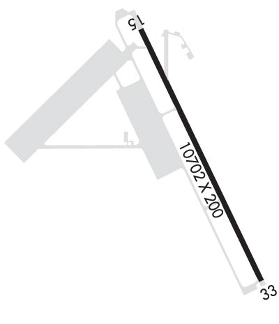
| Lat: N 3012.6 Long: W 09308.6 Elev: 17 Var: -00 Longest Runway: 10702 | ||
| Dept. ATIS: 120.0 Arr. ATIS: 120.0 AWOS: 120.0 Ground: 121.65 Tower: 124.2 | ||
| ||||||||||||||||||||||||||||||||||||||||||||
| ||||||||||||||||||||||||||||||||||||||||||||
| ||||||||||||||||||||||||||||||||||||||||||||
| Rwy | Rwy | |||||||
| 10702x200 | 10702' | 110.70 - 150° | 10702x200 | 10702' | ||||
| Runway ID | Single Wheel | Double Wheel | Double Tandem Wheel | Dual Double Wheel |
| 15/33 | 120,000 | 250,000 | 542,000 | 750,000 |
| These numbers are Advisory and are not limits. The Airport Manager should have more accurate Weight Limits | ||||
 Airport Diagram might not be current. | |
| Facility Name: | CHENNAULT INTL |
| City Name: | LAKE CHARLES |
| County: | CALCASIEU |
| State abbrev: | LA |
| State Name: | LOUISIANA |
| Ownership: | PUBLICLY OWNED |
| Use: | OPEN TO THE PUBLIC |
| Owner's Name: | CHENNAULT INTL ARPT AUTHORITY |
| Address: | 3650 SEN. J. BENNETT JOHNSTON AVE |
| LAKE CHARLES, LA 70615-6849 | |
| Owner's Phone: | 337-491-9961 |
| Manager's Name: | W. KEVIN MELTON |
| Address: | 3650 SEN. J. BENNETT JOHNSTON AVE |
| LAKE CHARLES, LA 70615-6849 | |
| Phone: | 337-491-9961 |
| FAA Region: | SOUTHWEST |
| FAA Field Office: | LNM |
| Date | Sunrise | Sunset |
|---|---|---|
| 04/25/24 Thursday | 6:34 | 19:47 |
| 04/26/24 Friday | 6:33 | 19:48 |
| 04/27/24 Saturday | 6:32 | 19:48 |
| 04/28/24 Sunday | 6:31 | 19:49 |
| 04/29/24 Monday | 6:31 | 19:50 |
| 04/30/24 Tuesday | 6:30 | 19:50 |
| 05/01/24 Wednesday | 6:29 | 19:51 |
| 05/02/24 Thursday | 6:28 | 19:51 |
| 05/03/24 Friday | 6:27 | 19:52 |
| 05/04/24 Saturday | 6:26 | 19:53 |
| 05/05/24 Sunday | 6:25 | 19:53 |
| 05/06/24 Monday | 6:25 | 19:54 |
| 05/07/24 Tuesday | 6:24 | 19:55 |
| 05/08/24 Wednesday | 6:23 | 19:55 |
| Airport Attendance Schedule | 7 Days A Week 0600-2200; AFT HRS CALL 337-433-7766. |
| Airport Status | OPERATIONAL (This Status can change at any time - please check NOTAMS) |
| Airport Lighting Schedule | WHEN ATCT CLSD ACTVT MALSR RWY 15; REIL RWY 33; PAPI RWY 15 & 33; HIRL RWY 15/33 - CTAF. |
| Airport Storage Available | Tie Downs, Hanger |
| Extra Services Available | Cargo Handling, Flight Instruction, Aircraft Rental |
| Wind Indicator | YES - (lighted) |
| Control Tower | YES |
| CTAF Frequency | 124.200 |
| Unicom Frequency | 122.950 |
| Rotating Beacon Color | WG |
| Segmented Circle | YES |
| Landing Fee | NO |
| Airport Inspected | STATE - performed by FAA AIRPORTS FIELD PERSONNEL |
| Inspection Date | 02/09/2024 |
| Type of Fuel Available | Grade 100LL, JET A-1 (icing inhibitor, freeze point -50C); -10FOR FUEL CALL 337-436-4877. SELF SVC AVBL 24 HRS WITH CREDIT CARD. |
| Airframe Repair Service | None |
| Power Plant Repair Service | None |
| Latitude | N3012.6 |
| Longitude | W09308.6 (ESTIMATED) |
| Arpt Elevation | 16ft (SURVEYED) |
| Magnetic Variation | 00E |
| 4 miles E | of LAKE CHARLES |
| Traffic Pattern Altitude | 1483 |
| Sectional Chart | HOUSTON |
| Operations (Reported) | Yearly | Avg. Daily |
|---|---|---|
| General Aviation Transient | 7372 | 20 |
| General Aviation Local | 4835 | 13 |
| Air Taxi | 1389 | 4 |
| Commerical | 86 | 0 |
| Commuter | 0 | 0 |
| Military | 16462 | 45 |
| Aircraft based on Field | |
|---|---|
| General Aviation Singles | 15 |
| General Aviation Multi | 5 |
| Jet Aircraft | 4 |
| General Aviation Helicopters | 0 |
| Military Aircraft | 0 |
| Gliders | 0 |
| Ultralights | 0 |
| FSS on field | NO |
| FSS tie-in | DE RIDDER |
| FSS Phone | 1-800-WX-BRIEF |
| Who issues Notams | CWF |
| Notam D service at airport | YES |
| ARTCC Name | HOUSTON |
| Airport Certification | 6 HRS PPR FOR ACR OPNS WITH MORE THAN 30 PSGR SEATS CALL AMGR 337-491-9961. ARFF INDEX E AVAILABLE 24/7 |
| Aircraft Rescue & Firefighting Index | AIRPORT HAS A CERTIFICATE UNDER CFR PART 139 |
| Airport of Entry | No |
| Custom Landing Rights | YES |
| Joint Civil/Military | No |
| Military Landing rights | YES |
| NATIONAL PLAN OF INTEGRATED AIRPORT SYSTEMS (NPIAS) |
| INDEX E AVBL WITH 24 HRS NOTICE CALL AMGR 337-491-9961. |
| BIRDS ON & INVOF OF ARPT |
| WHEN ATCT CLSD, FOR CD CTC HOUSTON ARTCC AT 281-230-5622. |
| PPR REQD FOR ACFT / HELO OPS IN THE INDUSTRIAL AREA |
| FOR PORT OF ENTRY REQ, CONTACT THE DIR OF OPS VIA CIAA@CHENNAULT.ORG AT LEAST 3 BUS DAYS (M-F) PRIOR TO PLANNED ARR. |
Airport Communications & Frequencies:
| |||||||||||||||||||||||||||
| Runway: 15 | Runway: 33 | ||
| Mag heading: | 154° | Mag heading: | 334° |
| Rwy Slope: | .02% Up | Rwy Slope: | -.02% Down |
| Approach: | ILS | Approach: | |
| Pattern: | Left Traffic | Pattern: | Right Traffic |
| Markings: | PRECISION INSTRUMENT | Markings: | PRECISION INSTRUMENT |
| Marking Condition: | FAIR | Marking Condition: | FAIR |
| Arresting Dev: | Arresting Dev: | ||
| Lat & Long: | N3013.4 W09309.0 | Lat. & Long.: | N3011.8 W09308.2 |
| Elev: | 14.4 ft. MSL | Elev: | 16.3 ft. MSL |
| TCH: | 53 ft. AGL | TCH: | 53 ft. AGL |
| Visual Glide Path: | 3.00 degrees | Visual Glide Path: | 3.00 degrees |
| Displaced Threshold: | No | Displaced Threshold: | No |
| Touchdown Zone: | YES | Touchdown Zone: | YES |
| Touchdown Elev.: | 15.8 feet | Touchdown Elev.: | 16.5 feet |
| Visual Glide Slope: | 4-Light PAPI on LEFT side of Runway | Visual Glide Slope: | 4-Light PAPI on LEFT side of Runway |
| RVR Equipment: | RVR Equipment: | ||
| RVV Equipment: | NO | RVV Equipment: | NO |
| Approach Lights: | MALSR - 1,400 foot medium intensity approach lighting system with runway alignment indicator lights | Approach Lights: | |
| REIL: | NO | REIL: | YES |
| Centerline Lights: | NO | Centerline Lights: | NO |
| Touchdown lights: | NO | Touchdown lights: | NO |
| Runway Category: | Precision Instrument Runway | Runway Category: | Runway with a Non-precision Approach having visibility minimums greater than 3/4 mile |
| Declared Distances: | TORA:10702' TODA:10702' ASDA:10702' LDA:10702' | Declared Distances: | TORA:10702' TODA:10702' ASDA:10702' LDA:10702' |
Thanks for using FltPlan.com
all rights reserved © 1999-2024 by Flight Plan LLC
