| BOWLING GREEN-WARREN COUNTY RE BOWLING GREEN KY |
| |
| Lat: N 3657.9 Long: W 08625.2 Elev: 547 Var: +04 Longest Runway: 6501 | ||
| AWOS: 127.82 CTAF: 123.0 | ||
| ||||||||||||||||||||||||||||||||||||||||||||||||||||||||||||||||||||
| ||||||||||||||||||||||||||||||||||||||||||||||||||||||||||||||||||||
| ||||||||||||||||||||||||||||||||||||||||||||||||||||||||||||||||||||
| ||||||||||||||||||||||||||||||||||||||||||||||||||||||||||||||||||||
| Rwy | Rwy | |||||||
| 6501x150 | 6501' | 108.75 - 033° | 6501x150 | 6501' | ||||
| 3956x150 | 3956' | 3956x150 | 3607' | |||||
| Runway ID | Single Wheel | Double Wheel | Double Tandem Wheel | Dual Double Wheel |
| 03/21 | 120,000 | 221,000 | 358,000 | N/A |
| 12/30 | 25,500 | 40,000 | N/A | N/A |
| These numbers are Advisory and are not limits. The Airport Manager should have more accurate Weight Limits | ||||
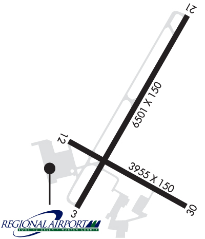 Airport Diagram might not be current. | |
| Facility Name: | BOWLING GREEN-WARREN COUNTY RGNL |
| City Name: | BOWLING GREEN |
| County: | WARREN |
| State abbrev: | KY |
| State Name: | KENTUCKY |
| Ownership: | PUBLICLY OWNED |
| Use: | OPEN TO THE PUBLIC |
| Owner's Name: | CITY BOWLING GREEN-WARREN CO |
| Address: | 1000 WOODHURST ST |
| BOWLING GREEN, KY 42103 | |
| Owner's Phone: | 270-842-1101 |
| Manager's Name: | SUSAN HARMON |
| Address: | 1000 WOODHURST ST |
| BOWLING GREEN, KY 42103 | |
| Phone: | 270-842-1101 |
| FAA Region: | SOUTHERN |
| FAA Field Office: | MEM |
| Date | Sunrise | Sunset |
|---|---|---|
| 04/25/24 Thursday | 5:58 | 19:30 |
| 04/26/24 Friday | 5:56 | 19:31 |
| 04/27/24 Saturday | 5:55 | 19:32 |
| 04/28/24 Sunday | 5:54 | 19:33 |
| 04/29/24 Monday | 5:53 | 19:34 |
| 04/30/24 Tuesday | 5:52 | 19:34 |
| 05/01/24 Wednesday | 5:51 | 19:35 |
| 05/02/24 Thursday | 5:49 | 19:36 |
| 05/03/24 Friday | 5:48 | 19:37 |
| 05/04/24 Saturday | 5:47 | 19:38 |
| 05/05/24 Sunday | 5:46 | 19:39 |
| 05/06/24 Monday | 5:45 | 19:40 |
| 05/07/24 Tuesday | 5:44 | 19:41 |
| 05/08/24 Wednesday | 5:43 | 19:41 |
| Airport Attendance Schedule | CONTINUOUS |
| Airport Status | OPERATIONAL (This Status can change at any time - please check NOTAMS) |
| Airport Lighting Schedule | ACTVT REIL RWY 03 & 21; HIRL RWY 03/21 - CTAF. |
| Airport Storage Available | Tie Downs, Hanger |
| Extra Services Available | Air Freight, Air Ambulance, Cargo Handling, Charter, Flight Instruction, Aircraft Rental, Aircraft Sales |
| Wind Indicator | YES - (lighted) |
| Control Tower | NO |
| CTAF Frequency | 123.000 |
| Unicom Frequency | 123.000 |
| Rotating Beacon Color | WG |
| Segmented Circle | NO |
| Landing Fee | NO |
| Airport Inspected | FEDERAL - performed by FAA AIRPORTS FIELD PERSONNEL |
| Inspection Date | 03/13/2024 |
| Type of Fuel Available | Grade 100LL, JET A (freeze point -40C) |
| Airframe Repair Service | MAJOR |
| Power Plant Repair Service | MAJOR |
| Latitude | N3657.9 |
| Longitude | W08625.2 (ESTIMATED) |
| Arpt Elevation | 547ft (SURVEYED) |
| Magnetic Variation | 04W |
| 2 miles SE | of BOWLING GREEN |
| Traffic Pattern Altitude | |
| Sectional Chart | ST LOUIS |
| Operations (Reported) | Yearly | Avg. Daily |
|---|---|---|
| General Aviation Transient | 6506 | 18 |
| General Aviation Local | 16976 | 47 |
| Air Taxi | 3479 | 10 |
| Commerical | 26 | 0 |
| Commuter | 0 | 0 |
| Military | 152 | 0 |
| Aircraft based on Field | |
|---|---|
| General Aviation Singles | 55 |
| General Aviation Multi | 9 |
| Jet Aircraft | 5 |
| General Aviation Helicopters | 2 |
| Military Aircraft | 0 |
| Gliders | 0 |
| Ultralights | 0 |
| FSS on field | NO |
| FSS tie-in | LOUISVILLE |
| FSS Phone | 1-800-WX-BRIEF |
| Who issues Notams | BWG |
| Notam D service at airport | YES |
| ARTCC Name | MEMPHIS |
| Airport Certification | OPS WITH MORE THAN 30 PAX SEATS 24 HR PPR - AMGR. |
| Aircraft Rescue & Firefighting Index | AIRPORT HAS A CERTIFICATE UNDER CFR PART 139 |
| Airport of Entry | No |
| Custom Landing Rights | No |
| Joint Civil/Military | No |
| Military Landing rights | YES |
| NATIONAL PLAN OF INTEGRATED AIRPORT SYSTEMS (NPIAS) |
| GRANT AGREEMENTS UNDER FAAP/ADAP/AIP |
| ASSURANCES PURSUANT TO TITLE VI, CIVIL RIGHTS ACT OF 1964 |
| AGREEMENT UNDER DLAND OR DCLA HAS EXPIRED. |
| BIRDS ON & INVOF ARPT. |
| CNL IFR - LOUISVILLE FSS 122.2. |
| FOR CD CTC MEMPHIS ARTCC AT 901-368-8453/8449. |
| RWY 12/3 0 NOT AVBL FOR SKED ACR OPS MORE THAN 9 PAX SEATS OR UNSKED ACR AT LEAST 31 PAX SEATS. |
| RWY 12/3 0 LONGL & TRANSVERSE CRACKING; UNEVEN SFC. |
Airport Communications & Frequencies:
| |||||||||
| Runway: 03 | Runway: 21 | ||
| Mag heading: | 34° | Mag heading: | 214° |
| Rwy Slope: | -.41% Down | Rwy Slope: | .41% Up |
| Approach: | ILS | Approach: | |
| Pattern: | Left Traffic | Pattern: | Left Traffic |
| Markings: | PRECISION INSTRUMENT | Markings: | NONPRECISION INSTRUMENT |
| Marking Condition: | GOOD | Marking Condition: | GOOD |
| Arresting Dev: | Arresting Dev: | ||
| Lat & Long: | N3657.5 W08625.5 | Lat. & Long.: | N3658.4 W08624.8 |
| Elev: | 547.1 ft. MSL | Elev: | 520.4 ft. MSL |
| TCH: | 44 ft. AGL | TCH: | 30 ft. AGL |
| Visual Glide Path: | 3.00 degrees | Visual Glide Path: | 3.00 degrees |
| Displaced Threshold: | No | Displaced Threshold: | No |
| Touchdown Zone: | YES | Touchdown Zone: | YES |
| Touchdown Elev.: | 547.2 feet | Touchdown Elev.: | 522.4 feet |
| Visual Glide Slope: | 4-Light PAPI on LEFT side of Runway | Visual Glide Slope: | 4-Light PAPI on LEFT side of Runway |
| RVR Equipment: | RVR Equipment: | ||
| RVV Equipment: | NO | RVV Equipment: | NO |
| Approach Lights: | Approach Lights: | ||
| REIL: | YES | REIL: | YES |
| Centerline Lights: | NO | Centerline Lights: | NO |
| Touchdown lights: | NO | Touchdown lights: | NO |
| Runway Category: | Precision Instrument Runway | Runway Category: | Runway with a Non-precision Approach having visibility minimums greater than 3/4 mile |
| Declared Distances: | TORA:6500' TODA:6500' ASDA:6500' LDA:6500' | Declared Distances: | TORA:6500' TODA:6500' ASDA:6500' LDA:6500' |
| Runway: 12 | Runway: 30 | ||
| Mag heading: | 124° | Mag heading: | 304° |
| Rwy Slope: | .01% Up | Rwy Slope: | -.01% Down |
| Approach: | Approach: | ||
| Pattern: | Left Traffic | Pattern: | Left Traffic |
| Markings: | BASIC | Markings: | BASIC |
| Marking Condition: | GOOD | Marking Condition: | GOOD |
| Arresting Dev: | Arresting Dev: | ||
| Lat & Long: | N3657.8 W08625.6 | Lat. & Long.: | N3657.5 W08624.8 |
| Elev: | 530.9 ft. MSL | Elev: | 531.2 ft. MSL |
| TCH: | TCH: | ||
| Visual Glide Path: | Visual Glide Path: | ||
| Displaced Threshold: | No | Displaced Threshold: | 349 feet |
| Touchdown Zone: | YES | Touchdown Zone: | YES |
| Touchdown Elev.: | 530.9 feet | Touchdown Elev.: | 529.1 feet |
| Visual Glide Slope: | Visual Glide Slope: | ||
| RVR Equipment: | RVR Equipment: | ||
| RVV Equipment: | NO | RVV Equipment: | NO |
| Approach Lights: | Approach Lights: | ||
| REIL: | NO | REIL: | NO |
| Centerline Lights: | NO | Centerline Lights: | NO |
| Touchdown lights: | NO | Touchdown lights: | NO |
| Runway Category: | Runway with a Visual Approach | Runway Category: | Runway with a Visual Approach |
| Declared Distances: | Declared Distances: |
Thanks for using FltPlan.com
all rights reserved © 1999-2024 by Flight Plan LLC