| BLAIR MUNI BLAIR NE |
| |
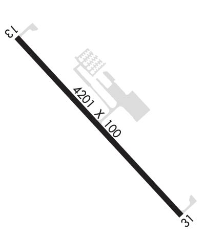
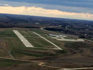
| Lat: N 4124.9 Long: W 09606.5 Elev: 1318 Var: -03 Longest Runway: 4201 | ||
| AWOS: 120.22 CTAF: 123.05 | ||
| |||||||||||||||||||||||||||||||
| |||||||||||||||||||||||||||||||
| |||||||||||||||||||||||||||||||
| |||||||||||||||||||||||||||||||
| Rwy | Rwy | |||||||
| 4201x100 | 4201' | 4201x100 | 4201' | |||||
| Runway ID | Single Wheel | Double Wheel | Double Tandem Wheel | Dual Double Wheel |
| 13/31 | 30,000 | 60,000 | N/A | N/A |
| These numbers are Advisory and are not limits. The Airport Manager should have more accurate Weight Limits | ||||
 Airport Diagram might not be current. | |
| Facility Name: | BLAIR EXEC |
| City Name: | BLAIR |
| County: | WASHINGTON |
| State abbrev: | NE |
| State Name: | NEBRASKA |
| Ownership: | PUBLICLY OWNED |
| Use: | OPEN TO THE PUBLIC |
| Owner's Name: | BLAIR AIRPORT AUTH |
| Address: | 218 SOUTH 16TH ST |
| BLAIR, NE 68008-2000 | |
| Owner's Phone: | 402-426-4191 |
| Manager's Name: | PHIL GRREN; CITY ADMINISTRATOR |
| Address: | 218 SOUTH 16TH ST |
| BLAIR, NE 68008-2000 | |
| Phone: | 402-426-6691 |
| FAA Region: | CENTRAL |
| FAA Field Office: | NONE |
| Date | Sunrise | Sunset |
|---|---|---|
| 04/24/24 Wednesday | 6:30 | 20:15 |
| 04/25/24 Thursday | 6:29 | 20:16 |
| 04/26/24 Friday | 6:27 | 20:18 |
| 04/27/24 Saturday | 6:26 | 20:19 |
| 04/28/24 Sunday | 6:25 | 20:20 |
| 04/29/24 Monday | 6:23 | 20:21 |
| 04/30/24 Tuesday | 6:22 | 20:22 |
| 05/01/24 Wednesday | 6:21 | 20:23 |
| 05/02/24 Thursday | 6:19 | 20:24 |
| 05/03/24 Friday | 6:18 | 20:25 |
| 05/04/24 Saturday | 6:17 | 20:26 |
| 05/05/24 Sunday | 6:16 | 20:27 |
| 05/06/24 Monday | 6:14 | 20:28 |
| 05/07/24 Tuesday | 6:13 | 20:29 |
| Airport Attendance Schedule | ON CALL; FOR SERVICE CALL 402-533-2247. |
| Airport Status | OPERATIONAL (This Status can change at any time - please check NOTAMS) |
| Airport Lighting Schedule | ACTVT MIRL RY 13/31; PAPI RYS 13 & 31, AND REIL RY 31-CTAF. |
| Airport Storage Available | Tie Downs |
| Extra Services Available | NONE |
| Wind Indicator | YES - (unlit) |
| Control Tower | NO |
| CTAF Frequency | 123.050 |
| Unicom Frequency | 123.050 |
| Rotating Beacon Color | WG |
| Segmented Circle | NO |
| Landing Fee | NO |
| Airport Inspected | STATE - performed by STATE AERONAUTICAL PERSONNEL |
| Inspection Date | 07/13/2021 |
| Type of Fuel Available | Grade 100LL, JET A (freeze point -40C); -1024 HR SELF SVC FUEL AVBL WITH CREDIT CARD. |
| Airframe Repair Service | NONE |
| Power Plant Repair Service | NONE |
| Latitude | N4124.9 |
| Longitude | W09606.5 (ESTIMATED; SURVEYED) |
| Arpt Elevation | 1317ft (SURVEYED) |
| Magnetic Variation | 03E |
| 7 miles S | of BLAIR |
| Traffic Pattern Altitude | |
| Sectional Chart | OMAHA |
| Operations (Reported) | Yearly | Avg. Daily |
|---|---|---|
| General Aviation Transient | 1800 | 5 |
| General Aviation Local | 18200 | 50 |
| Air Taxi | 0 | 0 |
| Commerical | 0 | 0 |
| Commuter | 0 | 0 |
| Military | 0 | 0 |
| Aircraft based on Field | |
|---|---|
| General Aviation Singles | 48 |
| General Aviation Multi | 6 |
| Jet Aircraft | 7 |
| General Aviation Helicopters | 3 |
| Military Aircraft | 0 |
| Gliders | 4 |
| Ultralights | 0 |
| FSS on field | NO |
| FSS tie-in | COLUMBUS |
| FSS Phone | 1-800-WX-BRIEF |
| Who issues Notams | BTA |
| Notam D service at airport | YES |
| ARTCC Name | MINNEAPOLIS |
| Airport Certification | |
| Aircraft Rescue & Firefighting Index | None |
| Airport of Entry | No |
| Custom Landing Rights | No |
| Joint Civil/Military | No |
| Military Landing rights | No |
| NATIONAL PLAN OF INTEGRATED AIRPORT SYSTEMS (NPIAS) |
| GLIDER ACTIVITY ON & INVOF ARPT. |
| FOR NOISE ABATEMENT PROCEDURES CONTACT AMGR ON 402-426-4191. |
| FOR CD CTC OMAHA APCH AT 402-682-4395. |
Airport Communications & Frequencies:
| ||||||||||||||
| Runway: 13 | Runway: 31 | ||
| Mag heading: | 134° | Mag heading: | 314° |
| Rwy Slope: | -.46% Down | Rwy Slope: | .46% Up |
| Approach: | Approach: | ||
| Pattern: | Left Traffic | Pattern: | Left Traffic |
| Markings: | NONPRECISION INSTRUMENT | Markings: | NONPRECISION INSTRUMENT |
| Marking Condition: | GOOD | Marking Condition: | GOOD |
| Arresting Dev: | Arresting Dev: | ||
| Lat & Long: | N4125.1 W09606.8 | Lat. & Long.: | N4124.6 W09606.2 |
| Elev: | 1317.6 ft. MSL | Elev: | 1298.4 ft. MSL |
| TCH: | 40 ft. AGL | TCH: | 40 ft. AGL |
| Visual Glide Path: | 3.00 degrees | Visual Glide Path: | 3.00 degrees |
| Displaced Threshold: | No | Displaced Threshold: | No |
| Touchdown Zone: | YES | Touchdown Zone: | YES |
| Touchdown Elev.: | 1317.6 feet | Touchdown Elev.: | 1314.5 feet |
| Visual Glide Slope: | 2-Light PAPI on LEFT side of Runway | Visual Glide Slope: | 2-Light PAPI on LEFT side of Runway |
| RVR Equipment: | RVR Equipment: | ||
| RVV Equipment: | NO | RVV Equipment: | NO |
| Approach Lights: | Approach Lights: | ||
| REIL: | NO | REIL: | YES |
| Centerline Lights: | NO | Centerline Lights: | NO |
| Touchdown lights: | NO | Touchdown lights: | NO |
| Runway Category: | Runway with a Non-precision Approach | Runway Category: | Runway with a Non-precision Approach |
| Declared Distances: | Declared Distances: |
Thanks for using FltPlan.com
all rights reserved © 1999-2024 by Flight Plan LLC