
| STEPHENS COUNTY BRECKENRIDGE TX |
| |
| Lat: N 3243.1 Long: W 09853.5 Elev: 1284 Var: -07 Longest Runway: 5002 | ||
| AWOS: 120.17 CTAF: 122.8 | ||
| |||||||||||||||||||||||||||||||||||||||||||||||||||||||||||||||||||||
| |||||||||||||||||||||||||||||||||||||||||||||||||||||||||||||||||||||
| |||||||||||||||||||||||||||||||||||||||||||||||||||||||||||||||||||||
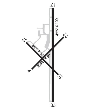
| Rwy | Rwy | |||||||
| 2398x50 | 2398' | 2398x50 | 2398' | |||||
| 2401x50 | 2401' | 2401x50 | 2281' | |||||
| 5002x100 | 5002' | 5002x100 | 5002' | |||||
| Runway ID | Single Wheel | Double Wheel | Double Tandem Wheel | Dual Double Wheel |
| 04/22 | 4,000 | N/A | N/A | N/A |
| 13/31 | 4,000 | N/A | N/A | N/A |
| 17/35 | 19,000 | N/A | N/A | N/A |
| These numbers are Advisory and are not limits. The Airport Manager should have more accurate Weight Limits | ||||
 Airport Diagram might not be current. | |
| Facility Name: | STEPHENS COUNTY |
| City Name: | BRECKENRIDGE |
| County: | STEPHENS |
| State abbrev: | TX |
| State Name: | TEXAS |
| Ownership: | PUBLICLY OWNED |
| Use: | OPEN TO THE PUBLIC |
| Owner's Name: | STEPHENS COUNTY |
| Address: | STEPHENS COUNTY COURTHOUSE, 200 WEST WALKER |
| BRECKENRIDGE, TX 76424 | |
| Owner's Phone: | 254-559-2190 |
| Manager's Name: | MICHAEL ROACH |
| Address: | STEPHENS COUNTY COURTHOUSE, 200 WEST WALKER |
| BRECKENRIDGE, TX 76424 | |
| Phone: | 254-559-2190 |
| FAA Region: | SOUTHWEST |
| FAA Field Office: | TEX |
| Date | Sunrise | Sunset |
|---|---|---|
| 04/25/24 Thursday | 6:54 | 20:13 |
| 04/26/24 Friday | 6:53 | 20:14 |
| 04/27/24 Saturday | 6:52 | 20:15 |
| 04/28/24 Sunday | 6:51 | 20:16 |
| 04/29/24 Monday | 6:50 | 20:16 |
| 04/30/24 Tuesday | 6:49 | 20:17 |
| 05/01/24 Wednesday | 6:48 | 20:18 |
| 05/02/24 Thursday | 6:47 | 20:19 |
| 05/03/24 Friday | 6:46 | 20:19 |
| 05/04/24 Saturday | 6:45 | 20:20 |
| 05/05/24 Sunday | 6:44 | 20:21 |
| 05/06/24 Monday | 6:43 | 20:22 |
| 05/07/24 Tuesday | 6:42 | 20:22 |
| 05/08/24 Wednesday | 6:41 | 20:23 |
| Airport Attendance Schedule | MON-FRI 0800-1700; AFTR HRS ON CALL. |
| Airport Status | OPERATIONAL (This Status can change at any time - please check NOTAMS) |
| Airport Lighting Schedule | MIRL RWY 17/35 PRESET LOW INTST; TO INCR INTST & ACTVT PAPI RWYS 17 & 35 - CTAF. |
| Airport Storage Available | Tie Downs |
| Extra Services Available | NONE |
| Wind Indicator | YES - (lighted) |
| Control Tower | NO |
| CTAF Frequency | 122.800 |
| Unicom Frequency | 122.800 |
| Rotating Beacon Color | WG |
| Segmented Circle | YES |
| Landing Fee | NO |
| Airport Inspected | STATE - performed by PRIVATE CONTRACT PERSONNEL |
| Inspection Date | 11/13/2023 |
| Type of Fuel Available | Grade 100LL, JET A (freeze point -40C) |
| Airframe Repair Service | MAJOR |
| Power Plant Repair Service | MAJOR |
| Latitude | N3243.1 |
| Longitude | W09853.5 (ESTIMATED) |
| Arpt Elevation | 1284ft (SURVEYED) |
| Magnetic Variation | 07E |
| 2 miles S | of BRECKENRIDGE |
| Traffic Pattern Altitude | |
| Sectional Chart | DALLAS-FT WORTH |
| Operations (Reported) | Yearly | Avg. Daily |
|---|---|---|
| General Aviation Transient | 3800 | 10 |
| General Aviation Local | 11400 | 31 |
| Air Taxi | 0 | 0 |
| Commerical | 0 | 0 |
| Commuter | 0 | 0 |
| Military | 0 | 0 |
| Aircraft based on Field | |
|---|---|
| General Aviation Singles | 11 |
| General Aviation Multi | 3 |
| Jet Aircraft | 0 |
| General Aviation Helicopters | 0 |
| Military Aircraft | 0 |
| Gliders | 0 |
| Ultralights | 0 |
| FSS on field | NO |
| FSS tie-in | FORT WORTH |
| FSS Phone | 1-800-WX-BRIEF |
| Who issues Notams | FTW |
| Notam D service at airport | YES |
| ARTCC Name | FORT WORTH |
| Airport Certification | |
| Aircraft Rescue & Firefighting Index | None |
| Airport of Entry | No |
| Custom Landing Rights | No |
| Joint Civil/Military | No |
| Military Landing rights | YES |
| NATIONAL PLAN OF INTEGRATED AIRPORT SYSTEMS (NPIAS) |
| GRANT AGREEMENTS UNDER FAAP/ADAP/AIP |
| ASSURANCES PURSUANT TO TITLE VI, CIVIL RIGHTS ACT OF 1964 |
Airport Communications & Frequencies:
| |||||||||
| Runway: 04 | Runway: 22 | ||
| Mag heading: | 38° | Mag heading: | 218° |
| Rwy Slope: | -.36% Down | Rwy Slope: | .36% Up |
| Approach: | Approach: | ||
| Pattern: | Left Traffic | Pattern: | Left Traffic |
| Markings: | BASIC | Markings: | BASIC |
| Marking Condition: | GOOD | Marking Condition: | GOOD |
| Arresting Dev: | Arresting Dev: | ||
| Lat & Long: | N3243.0 W09853.7 | Lat. & Long.: | N3243.3 W09853.3 |
| Elev: | 1263.0 ft. MSL | Elev: | 1254.3 ft. MSL |
| TCH: | TCH: | ||
| Visual Glide Path: | Visual Glide Path: | ||
| Displaced Threshold: | No | Displaced Threshold: | No |
| Touchdown Zone: | YES | Touchdown Zone: | YES |
| Touchdown Elev.: | 1263.0 feet | Touchdown Elev.: | 1263.0 feet |
| Visual Glide Slope: | Visual Glide Slope: | ||
| RVR Equipment: | RVR Equipment: | ||
| RVV Equipment: | NO | RVV Equipment: | NO |
| Approach Lights: | Approach Lights: | ||
| REIL: | NO | REIL: | NO |
| Centerline Lights: | NO | Centerline Lights: | NO |
| Touchdown lights: | NO | Touchdown lights: | NO |
| Runway Category: | Runway with a Visual Approach | Runway Category: | Runway with a Visual Approach |
| Declared Distances: | Declared Distances: | ||
| Obstructions: | TREE | Obstructions: | TREES |
| Marked: | NOT Marked/Lighted | Marked: | NOT Marked/Lighted |
| Clearance slope: | 2:1 | Clearance slope: | 8:1 |
| Obstruction height: | 20 feet AGL | Obstruction height: | 25 feet AGL |
| Dist. from runway: | 250 feet | Dist. from runway: | 400 feet |
| Centerline offset: | 85 right of centerline | Centerline offset: | |
| Comments: | 4 FT FENCE 150 FT DSTC ACRS APCH; 18 FT TREES 150 FT - 200 FT DSTC. | Comments: | 10 FT BRUSH, FT 0-199 FT DSTC, 85 FT L. |
| Runway: 13 | Runway: 31 | ||
| Mag heading: | 128° | Mag heading: | 308° |
| Rwy Slope: | 1.06% Up | Rwy Slope: | -1.06% Down |
| Approach: | Approach: | ||
| Pattern: | Left Traffic | Pattern: | Left Traffic |
| Markings: | BASIC | Markings: | BASIC |
| Marking Condition: | GOOD | Marking Condition: | GOOD |
| Arresting Dev: | Arresting Dev: | ||
| Lat & Long: | N3243.2 W09853.7 | Lat. & Long.: | N3243.0 W09853.4 |
| Elev: | 1246.9 ft. MSL | Elev: | 1272.4 ft. MSL |
| TCH: | TCH: | ||
| Visual Glide Path: | Visual Glide Path: | ||
| Displaced Threshold: | No | Displaced Threshold: | 120 feet |
| Touchdown Zone: | YES | Touchdown Zone: | YES |
| Touchdown Elev.: | 1272.4 feet | Touchdown Elev.: | 1272.4 feet |
| Visual Glide Slope: | Visual Glide Slope: | ||
| RVR Equipment: | RVR Equipment: | ||
| RVV Equipment: | NO | RVV Equipment: | NO |
| Approach Lights: | Approach Lights: | ||
| REIL: | NO | REIL: | NO |
| Centerline Lights: | NO | Centerline Lights: | NO |
| Touchdown lights: | NO | Touchdown lights: | NO |
| Runway Category: | Runway with a Visual Approach | Runway Category: | Runway with a Visual Approach |
| Declared Distances: | Declared Distances: | ||
| Obstructions: | TREES | Obstructions: | TREES |
| Marked: | NOT Marked/Lighted | Marked: | NOT Marked/Lighted |
| Clearance slope: | 4:1 | Clearance slope: | |
| Obstruction height: | 25 feet AGL | Obstruction height: | 20 feet AGL |
| Dist. from runway: | 305 feet | Dist. from runway: | 200 feet |
| Centerline offset: | 250 left of centerline | Centerline offset: | |
| Comments: | 4 FT FENCE 39-141 FT DSTC; 125 FT R. | Comments: | 5 FT FENCE 150 FT DSTC ACRS APCH; 20 FT TREES AND BRUSH 150 FT DSTC. |
| Runway: 17 | Runway: 35 | ||
| Mag heading: | 173° | Mag heading: | 353° |
| Rwy Slope: | .58% Up | Rwy Slope: | -.58% Down |
| Approach: | Approach: | ||
| Pattern: | Left Traffic | Pattern: | Left Traffic |
| Markings: | NONPRECISION INSTRUMENT | Markings: | NONPRECISION INSTRUMENT |
| Marking Condition: | GOOD | Marking Condition: | GOOD |
| Arresting Dev: | Arresting Dev: | ||
| Lat & Long: | N3243.5 W09853.5 | Lat. & Long.: | N3242.7 W09853.5 |
| Elev: | 1255.0 ft. MSL | Elev: | 1284.0 ft. MSL |
| TCH: | 40 ft. AGL | TCH: | 40 ft. AGL |
| Visual Glide Path: | 3.00 degrees | Visual Glide Path: | 3.00 degrees |
| Displaced Threshold: | No | Displaced Threshold: | No |
| Touchdown Zone: | YES | Touchdown Zone: | YES |
| Touchdown Elev.: | 1265.3 feet | Touchdown Elev.: | 1284.2 feet |
| Visual Glide Slope: | 2-Light PAPI on LEFT side of Runway | Visual Glide Slope: | 2-Light PAPI on LEFT side of Runway |
| RVR Equipment: | RVR Equipment: | ||
| RVV Equipment: | NO | RVV Equipment: | NO |
| Approach Lights: | Approach Lights: | ||
| REIL: | NO | REIL: | NO |
| Centerline Lights: | NO | Centerline Lights: | NO |
| Touchdown lights: | NO | Touchdown lights: | NO |
| Runway Category: | Runway with a Non-precision Approach having visibility minimums greater than 3/4 mile | Runway Category: | Runway with a Non-precision Approach having visibility minimums greater than 3/4 mile |
| Declared Distances: | Declared Distances: | ||
| Obstructions: | TREES | Obstructions: | TREES |
| Marked: | NOT Marked/Lighted | Marked: | NOT Marked/Lighted |
| Clearance slope: | 14:1; APCH SLOPE 8:1 TO DSPLCD THR OVR 25 FT TREE, 218 FT DSTC. | Clearance slope: | |
| Obstruction height: | 22 feet AGL | Obstruction height: | 17 feet AGL |
| Dist. from runway: | 528 feet | Dist. from runway: | 201 feet |
| Centerline offset: | 275 right of centerline | Centerline offset: | 170 feet right of centerline |
| Comments: | Comments: | 21 FT TREES 89 DSTC, 130 FT R. |
Thanks for using FltPlan.com
all rights reserved © 1999-2024 by Flight Plan LLC


