| ALGONA MUNI ALGONA IA |
| |
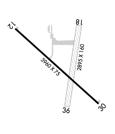
| Lat: N 4304.7 Long: W 09416.3 Elev: 1216 Var: -03 Longest Runway: 3960 | ||
| AWOS: 118.47 CTAF: 122.8 | ||
| |||||||||||||||||||||||||||||||||||||||||||||||||||||||||||||||||||||
| |||||||||||||||||||||||||||||||||||||||||||||||||||||||||||||||||||||
| |||||||||||||||||||||||||||||||||||||||||||||||||||||||||||||||||||||
| Rwy | Rwy | |||||||
| 3960x75 | 3960' | 3960x75 | 3960' | |||||
| 2895x160 | 2895' | 2895x160 | 2895' | |||||
| Runway ID | Single Wheel | Double Wheel | Double Tandem Wheel | Dual Double Wheel |
| 12/30 | 30,000 | 48,000 | N/A | N/A |
| 18/36 | N/A | N/A | N/A | N/A |
| These numbers are Advisory and are not limits. The Airport Manager should have more accurate Weight Limits | ||||
 Airport Diagram might not be current. | |
| Facility Name: | ALGONA MUNI |
| City Name: | ALGONA |
| County: | KOSSUTH |
| State abbrev: | IA |
| State Name: | IOWA |
| Ownership: | PUBLICLY OWNED |
| Use: | OPEN TO THE PUBLIC |
| Owner's Name: | CITY OF ALGONA |
| Address: | 112 WEST CALL |
| ALGONA, IA 50511 | |
| Owner's Phone: | 515-295-2411 |
| Manager's Name: | JIM KOHLHAAS |
| Address: | 2907 HWY 18 W |
| ALGONA, IA 50511 | |
| Phone: | 515-295-7492 |
| FAA Region: | CENTRAL |
| FAA Field Office: | NONE |
| Date | Sunrise | Sunset |
|---|---|---|
| 04/25/24 Thursday | 6:18 | 20:12 |
| 04/26/24 Friday | 6:17 | 20:13 |
| 04/27/24 Saturday | 6:15 | 20:15 |
| 04/28/24 Sunday | 6:14 | 20:16 |
| 04/29/24 Monday | 6:12 | 20:17 |
| 04/30/24 Tuesday | 6:11 | 20:18 |
| 05/01/24 Wednesday | 6:10 | 20:19 |
| 05/02/24 Thursday | 6:08 | 20:20 |
| 05/03/24 Friday | 6:07 | 20:21 |
| 05/04/24 Saturday | 6:06 | 20:23 |
| 05/05/24 Sunday | 6:04 | 20:24 |
| 05/06/24 Monday | 6:03 | 20:25 |
| 05/07/24 Tuesday | 6:02 | 20:26 |
| 05/08/24 Wednesday | 6:01 | 20:27 |
| Airport Attendance Schedule | MON-FRI 0800-1700, SAT 0800-1200 |
| Airport Status | OPERATIONAL (This Status can change at any time - please check NOTAMS) |
| Airport Lighting Schedule | ACTVT MIRL RY 12/30; REIL AND PAPI RYS 12 AND 30 - CTAF. |
| Airport Storage Available | Tie Downs, Hanger |
| Extra Services Available | Crop Dusting, Charter, Flight Instruction, Aircraft Rental |
| Wind Indicator | YES - (lighted) |
| Control Tower | NO |
| CTAF Frequency | 122.800 |
| Unicom Frequency | 122.800 |
| Rotating Beacon Color | WG |
| Segmented Circle | NO |
| Landing Fee | NO |
| Airport Inspected | STATE - performed by STATE AERONAUTICAL PERSONNEL |
| Inspection Date | 06/28/2023 |
| Type of Fuel Available | Grade 100LL, JET A (freeze point -40C) |
| Airframe Repair Service | MAJOR |
| Power Plant Repair Service | MAJOR |
| Latitude | N4304.7 |
| Longitude | W09416.3 (ESTIMATED) |
| Arpt Elevation | 1216ft (SURVEYED) |
| Magnetic Variation | 03E |
| 2 miles W | of ALGONA |
| Traffic Pattern Altitude | |
| Sectional Chart | OMAHA |
| Operations (Reported) | Yearly | Avg. Daily |
|---|---|---|
| General Aviation Transient | 5376 | 15 |
| General Aviation Local | 2124 | 6 |
| Air Taxi | 0 | 0 |
| Commerical | 0 | 0 |
| Commuter | 0 | 0 |
| Military | 0 | 0 |
| Aircraft based on Field | |
|---|---|
| General Aviation Singles | 28 |
| General Aviation Multi | 2 |
| Jet Aircraft | 0 |
| General Aviation Helicopters | 0 |
| Military Aircraft | 0 |
| Gliders | 0 |
| Ultralights | 0 |
| FSS on field | NO |
| FSS tie-in | FORT DODGE |
| FSS Phone | 1-800-WX-BRIEF |
| Who issues Notams | AXA |
| Notam D service at airport | YES |
| ARTCC Name | MINNEAPOLIS |
| Airport Certification | |
| Aircraft Rescue & Firefighting Index | None |
| Airport of Entry | No |
| Custom Landing Rights | No |
| Joint Civil/Military | No |
| Military Landing rights | YES |
| NATIONAL PLAN OF INTEGRATED AIRPORT SYSTEMS (NPIAS) |
| GRANT AGREEMENTS UNDER FAAP/ADAP/AIP |
| SURPLUS PROPERTY AGREEMENT UNDER PUBLIC LAW 289 |
| ASSURANCES PURSUANT TO TITLE VI, CIVIL RIGHTS ACT OF 1964 |
| RY 12 IS CALM WIND RY. |
| FOR CD CTC MINNEAPOLIS ARTCC AT 651-463-5588. |
Airport Communications & Frequencies:
| |||||||||
| Runway: 12 | Runway: 30 | ||
| Mag heading: | 129° | Mag heading: | 309° |
| Rwy Slope: | -.27% Down | Rwy Slope: | .27% Up |
| Approach: | Approach: | ||
| Pattern: | Left Traffic | Pattern: | Left Traffic |
| Markings: | NONPRECISION INSTRUMENT | Markings: | NONPRECISION INSTRUMENT |
| Marking Condition: | FAIR | Marking Condition: | FAIR |
| Arresting Dev: | Arresting Dev: | ||
| Lat & Long: | N4304.9 W09416.7 | Lat. & Long.: | N4304.5 W09416.0 |
| Elev: | 1214.7 ft. MSL | Elev: | 1204.1 ft. MSL |
| TCH: | 40 ft. AGL | TCH: | 40 ft. AGL |
| Visual Glide Path: | 3.00 degrees | Visual Glide Path: | 3.00 degrees |
| Displaced Threshold: | No | Displaced Threshold: | No |
| Touchdown Zone: | YES | Touchdown Zone: | YES |
| Touchdown Elev.: | 1214.7 feet | Touchdown Elev.: | 1213.2 feet |
| Visual Glide Slope: | 2-Light PAPI on LEFT side of Runway | Visual Glide Slope: | 2-Light PAPI on LEFT side of Runway |
| RVR Equipment: | RVR Equipment: | ||
| RVV Equipment: | NO | RVV Equipment: | NO |
| Approach Lights: | Approach Lights: | ||
| REIL: | YES | REIL: | YES |
| Centerline Lights: | NO | Centerline Lights: | NO |
| Touchdown lights: | NO | Touchdown lights: | NO |
| Runway Category: | Runway with a Non-precision Approach having visibility minimums greater than 3/4 mile | Runway Category: | Runway with a Non-precision Approach having visibility minimums greater than 3/4 mile |
| Declared Distances: | Declared Distances: | ||
| Obstructions: | ROAD | Obstructions: | TREES |
| Marked: | NOT Marked/Lighted | Marked: | NOT Marked/Lighted |
| Clearance slope: | 13:1 | Clearance slope: | 10:1 |
| Obstruction height: | 22 feet AGL | Obstruction height: | 58 feet AGL |
| Dist. from runway: | 500 feet | Dist. from runway: | 836 feet |
| Centerline offset: | 285 left of centerline | Centerline offset: | 379 feet right of centerline |
| Comments: | Comments: |
| Runway: 18 | Runway: 36 | ||
| Mag heading: | 186° | Mag heading: | 6° |
| Rwy Slope: | -.35% Down | Rwy Slope: | .35% Up |
| Approach: | Approach: | ||
| Pattern: | Left Traffic | Pattern: | Left Traffic |
| Markings: | NONSTANDARD | Markings: | NONSTANDARD |
| Marking Condition: | RY 18/36 MKD WITH YELLOW CONES. | Marking Condition: | |
| Arresting Dev: | Arresting Dev: | ||
| Lat & Long: | N4304.9 W09416.2 | Lat. & Long.: | N4304.4 W09416.3 |
| Elev: | 1214.4 ft. MSL | Elev: | 1204.2 ft. MSL |
| TCH: | TCH: | ||
| Visual Glide Path: | Visual Glide Path: | ||
| Displaced Threshold: | No | Displaced Threshold: | No |
| Touchdown Zone: | YES | Touchdown Zone: | YES |
| Touchdown Elev.: | 1214.4 feet | Touchdown Elev.: | 1214.4 feet |
| Visual Glide Slope: | Visual Glide Slope: | ||
| RVR Equipment: | RVR Equipment: | ||
| RVV Equipment: | NO | RVV Equipment: | NO |
| Approach Lights: | Approach Lights: | ||
| REIL: | NO | REIL: | NO |
| Centerline Lights: | NO | Centerline Lights: | NO |
| Touchdown lights: | NO | Touchdown lights: | NO |
| Runway Category: | Runway with a Visual Approach | Runway Category: | Runway with a Visual Approach |
| Declared Distances: | Declared Distances: | ||
| Obstructions: | ROAD | Obstructions: | FENCE |
| Marked: | NOT Marked/Lighted | Marked: | NOT Marked/Lighted |
| Clearance slope: | 22:1 | Clearance slope: | 33:1 |
| Obstruction height: | 15 feet AGL | Obstruction height: | 4 feet AGL |
| Dist. from runway: | 340 feet | Dist. from runway: | 135 feet |
| Centerline offset: | Centerline offset: | ||
| Comments: | Comments: | 4' FENCE 135' FROM RWY END |
Thanks for using FltPlan.com
all rights reserved © 1999-2024 by Flight Plan LLC