
| MARANA RGNL MARANA AZ |
| |
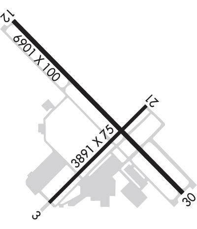
| Lat: N 3224.6 Long: W 11113.1 Elev: 2032 Var: -12 Longest Runway: 6901 | ||
| AWOS: 118.37 CTAF: 123.0 | ||
| ||||||||||||||||||||||||||||||||||||||||||||
| ||||||||||||||||||||||||||||||||||||||||||||
| ||||||||||||||||||||||||||||||||||||||||||||
| Rwy | Rwy | |||||||
| 3892x75 | 3398' | 3892x75 | 3892' | |||||
| 6901x100 | 6901' | 6901x100 | 6901' | |||||
| Runway ID | Single Wheel | Double Wheel | Double Tandem Wheel | Dual Double Wheel |
| 03/21 | 75,000 | 100,000 | 150,000 | N/A |
| 12/30 | 75,000 | 100,000 | 300,000 | N/A |
| These numbers are Advisory and are not limits. The Airport Manager should have more accurate Weight Limits | ||||
 Airport Diagram might not be current. | |
| Facility Name: | MARANA RGNL |
| City Name: | MARANA |
| County: | PIMA |
| State abbrev: | AZ |
| State Name: | ARIZONA |
| Ownership: | PUBLICLY OWNED |
| Use: | OPEN TO THE PUBLIC |
| Owner's Name: | TOWN OF MARANA |
| Address: | 11555 W. CIVIC CENTER DRIVE |
| MARANA, AZ 85653 | |
| Owner's Phone: | 520-382-1999 |
| Manager's Name: | GALEN BEEM |
| Address: | 11700 W. AVRA VALLEY RD, #91, TOWN OF MARANA |
| MARANA, AZ 85653 | |
| Phone: | 520-382-8053; 520-382-2607 |
| FAA Region: | WESTERN-PACIFIC |
| FAA Field Office: | PHX |
| Date | Sunrise | Sunset |
|---|---|---|
| 04/25/24 Thursday | 5:44 | 19:02 |
| 04/26/24 Friday | 5:42 | 19:03 |
| 04/27/24 Saturday | 5:41 | 19:04 |
| 04/28/24 Sunday | 5:40 | 19:05 |
| 04/29/24 Monday | 5:39 | 19:05 |
| 04/30/24 Tuesday | 5:38 | 19:06 |
| 05/01/24 Wednesday | 5:38 | 19:07 |
| 05/02/24 Thursday | 5:37 | 19:07 |
| 05/03/24 Friday | 5:36 | 19:08 |
| 05/04/24 Saturday | 5:35 | 19:09 |
| 05/05/24 Sunday | 5:34 | 19:10 |
| 05/06/24 Monday | 5:33 | 19:10 |
| 05/07/24 Tuesday | 5:32 | 19:11 |
| 05/08/24 Wednesday | 5:31 | 19:12 |
| Airport Attendance Schedule | 7 Days A Week 0700-1730 |
| Airport Status | OPERATIONAL (This Status can change at any time - please check NOTAMS) |
| Airport Lighting Schedule | ACTVT REIL RWY 12 & 30; MIRL RWY 03/21 & 12/30 - CTAF. PAPI RWY 03, 12, 21 & 30 ON CONSLY. |
| Airport Storage Available | Tie Downs, Hanger |
| Extra Services Available | Flight Instruction, Parachute Jumping, Aircraft Rental |
| Wind Indicator | YES - (lighted) |
| Control Tower | NO |
| CTAF Frequency | 123.000 |
| Unicom Frequency | 123.000 |
| Rotating Beacon Color | WG |
| Segmented Circle | YES |
| Landing Fee | NO |
| Airport Inspected | STATE - performed by PRIVATE CONTRACT PERSONNEL |
| Inspection Date | 04/15/2023 |
| Type of Fuel Available | Grade 100LL, JET A (freeze point -40C) |
| Airframe Repair Service | MAJOR |
| Power Plant Repair Service | MINOR |
| Latitude | N3224.6 |
| Longitude | W11113.1 (ESTIMATED) |
| Arpt Elevation | 2031ft (SURVEYED) |
| Magnetic Variation | 12E |
| 15 miles NW | of MARANA |
| Traffic Pattern Altitude | |
| Sectional Chart | PHOENIX |
| Operations (Reported) | Yearly | Avg. Daily |
|---|---|---|
| General Aviation Transient | 30000 | 82 |
| General Aviation Local | 30000 | 82 |
| Air Taxi | 10000 | 27 |
| Commerical | 0 | 0 |
| Commuter | 0 | 0 |
| Military | 20252 | 55 |
| Aircraft based on Field | |
|---|---|
| General Aviation Singles | 165 |
| General Aviation Multi | 15 |
| Jet Aircraft | 2 |
| General Aviation Helicopters | 0 |
| Military Aircraft | 0 |
| Gliders | 1 |
| Ultralights | 10 |
| FSS on field | NO |
| FSS tie-in | PRESCOTT |
| FSS Phone | 1-800-WX-BRIEF |
| Who issues Notams | PRC |
| Notam D service at airport | YES |
| ARTCC Name | ALBUQUERQUE |
| Airport Certification | |
| Aircraft Rescue & Firefighting Index | None |
| Airport of Entry | No |
| Custom Landing Rights | No |
| Joint Civil/Military | No |
| Military Landing rights | No |
| NATIONAL PLAN OF INTEGRATED AIRPORT SYSTEMS (NPIAS) |
| GRANT AGREEMENTS UNDER FAAP/ADAP/AIP |
| ASSURANCES PURSUANT TO TITLE VI, CIVIL RIGHTS ACT OF 1964 |
| AEROBATIC ACT 2 MI SE SFC-7000 FT MSL; HIGH & LOW LEVEL PRCHT TRNG NW QUAD. |
| FOR CD CTC TUCSON APCH AT 520-829-6121. |
| PREF TFC PAT ALT 3000 FT MSL, LIGHT ACFT; 3500 FT MSL, HEAVY ACFT. |
| FRMN FLT PPR WI 5 NM - AMGR. |
| SELF SVC CREDIT CARD FUEL H24. AFT HR CALL OUT FEE - 520-730-4318. |
| HOT AIR BALLON OPS NA. |
| HEL LND SE HELIPAD ONLY; FUEL & TERM RAMP LNDG NA. |
| RWY 12/3 0 RWY 12 CALM WIND RWY. |
Airport Communications & Frequencies:
| ||||||||||||||
| Runway: 03 | Runway: 21 | ||
| Mag heading: | 33° | Mag heading: | 213° |
| Rwy Slope: | .14% Up | Rwy Slope: | -.14% Down |
| Approach: | Approach: | ||
| Pattern: | Right Traffic | Pattern: | Left Traffic |
| Markings: | BASIC | Markings: | BASIC |
| Marking Condition: | GOOD | Marking Condition: | GOOD |
| Arresting Dev: | Arresting Dev: | ||
| Lat & Long: | N3224.2 W11113.4 | Lat. & Long.: | N3224.7 W11112.8 |
| Elev: | 2019.0 ft. MSL | Elev: | 2024.6 ft. MSL |
| TCH: | 53 ft. AGL | TCH: | 41 ft. AGL |
| Visual Glide Path: | 2.91 degrees | Visual Glide Path: | 2.91 degrees |
| Displaced Threshold: | 494 feet | Displaced Threshold: | No |
| Touchdown Zone: | YES | Touchdown Zone: | YES |
| Touchdown Elev.: | 2025.9 feet | Touchdown Elev.: | 2025.9 feet |
| Visual Glide Slope: | 2-Light PAPI on LEFT side of Runway | Visual Glide Slope: | 2-Light PAPI on LEFT side of Runway; PAPI UNUSBL BYD 7.0 NM DUE TO TRRN. |
| RVR Equipment: | RVR Equipment: | ||
| RVV Equipment: | NO | RVV Equipment: | NO |
| Approach Lights: | Approach Lights: | ||
| REIL: | YES | REIL: | YES |
| Centerline Lights: | NO | Centerline Lights: | NO |
| Touchdown lights: | NO | Touchdown lights: | NO |
| Runway Category: | Runway with a Non-precision Approach | Runway Category: | Runway with a Non-precision Approach |
| Declared Distances: | Declared Distances: | ||
| Obstructions: | ROAD | Obstructions: | BRUSH |
| Marked: | NOT Marked/Lighted | Marked: | NOT Marked/Lighted |
| Clearance slope: | APCH RATIO 50:1 TO DTHR. | Clearance slope: | 1:1 |
| Obstruction height: | 15 feet AGL | Obstruction height: | 13 feet AGL |
| Dist. from runway: | 200 feet | Dist. from runway: | 225 feet |
| Centerline offset: | 250 right of centerline | Centerline offset: | 150 feet right of centerline |
| Comments: | Comments: |
| Runway: 12 | Runway: 30 | ||
| Mag heading: | 123° | Mag heading: | 303° |
| Rwy Slope: | .30% Up | Rwy Slope: | -.30% Down |
| Approach: | Approach: | ||
| Pattern: | Left Traffic | Pattern: | Right Traffic |
| Markings: | NONPRECISION INSTRUMENT | Markings: | NONPRECISION INSTRUMENT |
| Marking Condition: | GOOD | Marking Condition: | GOOD |
| Arresting Dev: | Arresting Dev: | ||
| Lat & Long: | N3225.1 W11113.6 | Lat. & Long.: | N3224.2 W11112.6 |
| Elev: | 2010.6 ft. MSL | Elev: | 2031.4 ft. MSL |
| TCH: | 45 ft. AGL | TCH: | 45 ft. AGL |
| Visual Glide Path: | 3.06 degrees | Visual Glide Path: | 3.41 degrees |
| Displaced Threshold: | No | Displaced Threshold: | No |
| Touchdown Zone: | YES | Touchdown Zone: | YES |
| Touchdown Elev.: | 2022.0 feet | Touchdown Elev.: | 2031.5 feet |
| Visual Glide Slope: | 4-Light PAPI on LEFT side of Runway | Visual Glide Slope: | 4-Light PAPI on LEFT side of Runway; PAPI UNUSBL BYD 3.5 NM DUE TO TRRN. |
| RVR Equipment: | RVR Equipment: | ||
| RVV Equipment: | NO | RVV Equipment: | NO |
| Approach Lights: | Approach Lights: | ||
| REIL: | YES | REIL: | YES |
| Centerline Lights: | NO | Centerline Lights: | NO |
| Touchdown lights: | NO | Touchdown lights: | NO |
| Runway Category: | Runway with a Non-precision Approach having visibility minimums greater than 3/4 mile | Runway Category: | Runway with a Visual Approach |
| Declared Distances: | Declared Distances: |
Thanks for using FltPlan.com
all rights reserved © 1999-2024 by Flight Plan LLC
