
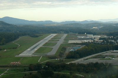
| ASHEVILLE RGNL ASHEVILLE NC |
| |
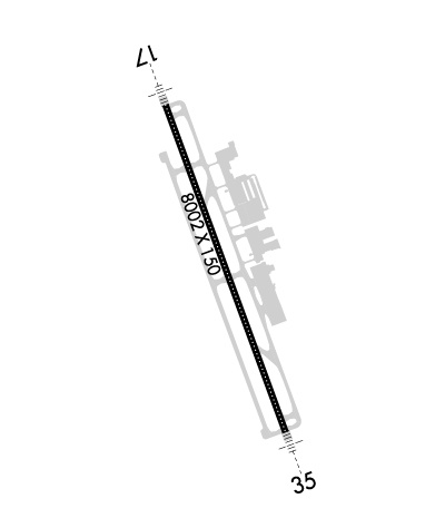
| Lat: N 3526.2 Long: W 08232.5 Elev: 2164 Var: +07 Longest Runway: 8002 | ||
| Dept. ATIS: 120.2 Arr. ATIS: 120.2 AWOS: 120.2 Ground: 121.9 Tower: 121.1 | ||
| ||||||||||||||||||||||||||||||||||||||||||||
| ||||||||||||||||||||||||||||||||||||||||||||
| ||||||||||||||||||||||||||||||||||||||||||||
| Rwy | Rwy | |||||||
| 8002x150 | 8002' | 110.90 - 166° | 8002x150 | 8002' | 110.50 - 346° | |||
| Runway ID | Single Wheel | Double Wheel | Double Tandem Wheel | Dual Double Wheel |
| 17/35 | 120,000 | 219,000 | 404,000 | 837,000 |
| These numbers are Advisory and are not limits. The Airport Manager should have more accurate Weight Limits | ||||
 Airport Diagram might not be current. | |
| Facility Name: | ASHEVILLE RGNL |
| City Name: | ASHEVILLE |
| County: | BUNCOMBE |
| State abbrev: | NC |
| State Name: | NORTH CAROLINA |
| Ownership: | PUBLICLY OWNED |
| Use: | OPEN TO THE PUBLIC |
| Owner's Name: | GREATER ASHEVILLE RGNL ARPT AUTH. |
| Address: | 61 TERMINAL DR SUITE 1 |
| FLETCHER, NC 28732-9442 | |
| Owner's Phone: | 828-684-2226 |
| Manager's Name: | LEW S. BLEIWEIS, A.A.E. |
| Address: | 61 TERMINAL DRIVE; SUITE 1 |
| FLETCHER, NC 28731-9442 | |
| Phone: | 828-684-4577; (828) 684-4577 OR EMERG CTC - (828) 209-5100. |
| FAA Region: | SOUTHERN |
| FAA Field Office: | MEM |
| Date | Sunrise | Sunset |
|---|---|---|
| 04/24/24 Wednesday | 6:46 | 20:11 |
| 04/25/24 Thursday | 6:44 | 20:12 |
| 04/26/24 Friday | 6:43 | 20:13 |
| 04/27/24 Saturday | 6:42 | 20:14 |
| 04/28/24 Sunday | 6:41 | 20:15 |
| 04/29/24 Monday | 6:40 | 20:15 |
| 04/30/24 Tuesday | 6:39 | 20:16 |
| 05/01/24 Wednesday | 6:38 | 20:17 |
| 05/02/24 Thursday | 6:37 | 20:18 |
| 05/03/24 Friday | 6:36 | 20:19 |
| 05/04/24 Saturday | 6:35 | 20:20 |
| 05/05/24 Sunday | 6:34 | 20:20 |
| 05/06/24 Monday | 6:33 | 20:21 |
| 05/07/24 Tuesday | 6:32 | 20:22 |
| Airport Attendance Schedule | CONTINUOUS |
| Airport Status | OPERATIONAL (This Status can change at any time - please check NOTAMS) |
| Airport Lighting Schedule | WHEN TWR CLSD, ACTVT MALSR RWY 17 & 35; PAPI RWYS 17 & 35; HIRLS RWY 17/35 - CTAF. |
| Airport Storage Available | Tie Downs, Hanger |
| Extra Services Available | Air Freight, Cargo Handling, Charter, Flight Instruction, Aircraft Rental |
| Wind Indicator | YES - (lighted) |
| Control Tower | YES |
| CTAF Frequency | 121.100 |
| Unicom Frequency | 122.950 |
| Rotating Beacon Color | WG |
| Segmented Circle | YES |
| Landing Fee | NO |
| Airport Inspected | FEDERAL - performed by FAA AIRPORTS FIELD PERSONNEL |
| Inspection Date | 05/11/2023 |
| Type of Fuel Available | Grade 100LL, JET A (freeze point -40C) |
| Airframe Repair Service | MINOR |
| Power Plant Repair Service | MINOR |
| Latitude | N3526.2 |
| Longitude | W08232.5 (ESTIMATED) |
| Arpt Elevation | 2163ft (SURVEYED) |
| Magnetic Variation | 07W |
| 9 miles S | of ASHEVILLE |
| Traffic Pattern Altitude | |
| Sectional Chart | ATLANTA |
| Operations (Reported) | Yearly | Avg. Daily |
|---|---|---|
| General Aviation Transient | 30014 | 82 |
| General Aviation Local | 17721 | 49 |
| Air Taxi | 10036 | 27 |
| Commerical | 17926 | 49 |
| Commuter | 0 | 0 |
| Military | 4502 | 12 |
| Aircraft based on Field | |
|---|---|
| General Aviation Singles | 113 |
| General Aviation Multi | 10 |
| Jet Aircraft | 7 |
| General Aviation Helicopters | 2 |
| Military Aircraft | 0 |
| Gliders | 0 |
| Ultralights | 0 |
| FSS on field | NO |
| FSS tie-in | RALEIGH |
| FSS Phone | 1-800-WX-BRIEF |
| Who issues Notams | AVL |
| Notam D service at airport | YES |
| ARTCC Name | ATLANTA |
| Airport Certification | AIRPORT RECEIVING SCHEDULED AIR CARRIER SERVICE FROM CARRIERS CERTIFICATED BY THE CIVIL AERONAUTICS BOARD; PPR FOR UNSKED ACR OPNS WITH MORE THAN 30 PSGR SEATS 0400-1200Z; CALL APRT COMM 828-684-4577. |
| Aircraft Rescue & Firefighting Index | AIRPORT HAS A CERTIFICATE UNDER CFR PART 139 |
| Airport of Entry | No |
| Custom Landing Rights | No |
| Joint Civil/Military | No |
| Military Landing rights | YES |
| NATIONAL PLAN OF INTEGRATED AIRPORT SYSTEMS (NPIAS) |
| GRANT AGREEMENTS UNDER FAAP/ADAP/AIP |
| ASSURANCES PURSUANT TO TITLE VI, CIVIL RIGHTS ACT OF 1964 |
| FOR THE ASHEVILLE REGIONAL AIRPORT AIRCRAFT DIVERSIONS EMERGENCY CONTINGENCY PLAN AND FACILITY CONSTRAINTS CTC ARPT ADMIN AT 828-684-2226. |
| FLOCKS OF MIGRATORY BIRDS ON AND INVOF ARPT. |
| WHEN ATCT CLSD, FOR CD CTC ATLANTA ARTCC AT 770-210-7692. |
Airport Communications & Frequencies:
| |||||||||||||||||||||||||||||||||||||||||||||
| Runway: 17 | Runway: 35 | ||
| Mag heading: | 167° | Mag heading: | 347° |
| Rwy Slope: | -.58% Down | Rwy Slope: | .58% Up |
| Approach: | ILS/DME | Approach: | ILS/DME |
| Pattern: | Left Traffic | Pattern: | Right Traffic; RWY 35 RIGHT TRAFFIC WHEN ATCT CLSD. |
| Markings: | PRECISION INSTRUMENT | Markings: | PRECISION INSTRUMENT |
| Marking Condition: | GOOD | Marking Condition: | GOOD |
| Arresting Dev: | Arresting Dev: | ||
| Lat & Long: | N3526.8 W08232.8 | Lat. & Long.: | N3525.5 W08232.2 |
| Elev: | 2163.9 ft. MSL | Elev: | 2117.4 ft. MSL |
| TCH: | 55 ft. AGL | TCH: | 56 ft. AGL |
| Visual Glide Path: | 3.00 degrees | Visual Glide Path: | 3.00 degrees |
| Displaced Threshold: | No | Displaced Threshold: | No |
| Touchdown Zone: | YES | Touchdown Zone: | YES |
| Touchdown Elev.: | 2163.9 feet | Touchdown Elev.: | 2141.3 feet |
| Visual Glide Slope: | 4-Light PAPI on RIGHT side of Runway | Visual Glide Slope: | 4-Light PAPI on LEFT side of Runway |
| RVR Equipment: | TOUCHDOWN-ROLLOUT | RVR Equipment: | TOUCHDOWN-ROLLOUT |
| RVV Equipment: | NO | RVV Equipment: | NO |
| Approach Lights: | MALSR - 1,400 foot medium intensity approach lighting system with runway alignment indicator lights | Approach Lights: | MALSR - 1,400 foot medium intensity approach lighting system with runway alignment indicator lights |
| REIL: | NO | REIL: | NO |
| Centerline Lights: | YES | Centerline Lights: | YES |
| Touchdown lights: | NO | Touchdown lights: | YES |
| Runway Category: | Precision Instrument Runway | Runway Category: | Precision Instrument Runway |
| Declared Distances: | TORA:8002' TODA:8002' ASDA:8002' LDA:8002' | Declared Distances: | TORA:8002' TODA:8002' ASDA:8002' LDA:8002' |
Thanks for using FltPlan.com
all rights reserved © 1999-2024 by Flight Plan LLC