
| ASTORIA RGNL ASTORIA OR |
| |
| Lat: N 4609.5 Long: W 12352.7 Elev: 15 Var: -15 Longest Runway: 5794 | ||
| AWOS: 135.37 CTAF: 122.8 | ||
| ||||||||||||||||||||||||||||||||||||||||||||||||||||||||||||||||||||
| ||||||||||||||||||||||||||||||||||||||||||||||||||||||||||||||||||||
| ||||||||||||||||||||||||||||||||||||||||||||||||||||||||||||||||||||
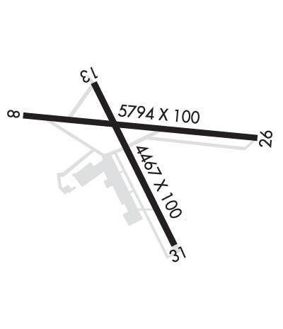
| Rwy | Rwy | |||||||
| 5794x100 | 5494' | 5794x100 | 5081' | 109.50 - 260° | ||||
| 4467x100 | 4467' | 4467x100 | 4467' | |||||
| Runway ID | Single Wheel | Double Wheel | Double Tandem Wheel | Dual Double Wheel |
| 08/26 | 60,000 | 76,000 | 119,000 | N/A |
| 14/32 | 60,000 | 76,000 | 119,000 | N/A |
| These numbers are Advisory and are not limits. The Airport Manager should have more accurate Weight Limits | ||||
 Airport Diagram might not be current. | |
| Facility Name: | ASTORIA RGNL |
| City Name: | ASTORIA |
| County: | CLATSOP |
| State abbrev: | OR |
| State Name: | OREGON |
| Ownership: | PUBLICLY OWNED |
| Use: | OPEN TO THE PUBLIC |
| Owner's Name: | PORT OF ASTORIA |
| Address: | 422 GATEWAY AVENUE, SUITE 100, SUITE 103 |
| ASTORIA, OR 97103 | |
| Owner's Phone: | 503-741-3300 |
| Manager's Name: | MATT MCGRATH |
| Address: | 422 GATEWAY AVENUE, SUITE 100 |
| ASTORIA, OR 97103 | |
| Phone: | 503-298-0909 |
| FAA Region: | NORTHWEST MOUNTAIN |
| FAA Field Office: | SEA |
| Date | Sunrise | Sunset |
|---|---|---|
| 04/25/24 Thursday | 6:10 | 20:17 |
| 04/26/24 Friday | 6:09 | 20:19 |
| 04/27/24 Saturday | 6:07 | 20:20 |
| 04/28/24 Sunday | 6:05 | 20:21 |
| 04/29/24 Monday | 6:04 | 20:22 |
| 04/30/24 Tuesday | 6:02 | 20:24 |
| 05/01/24 Wednesday | 6:01 | 20:25 |
| 05/02/24 Thursday | 5:59 | 20:26 |
| 05/03/24 Friday | 5:58 | 20:28 |
| 05/04/24 Saturday | 5:56 | 20:29 |
| 05/05/24 Sunday | 5:55 | 20:30 |
| 05/06/24 Monday | 5:53 | 20:31 |
| 05/07/24 Tuesday | 5:52 | 20:33 |
| 05/08/24 Wednesday | 5:51 | 20:34 |
| Airport Attendance Schedule | 7 Days A Week 0800-1700; FOR FUEL OUTSIDE NML WORKING HRS CTC FBO 503-298-7531. |
| Airport Status | OPERATIONAL (This Status can change at any time - please check NOTAMS) |
| Airport Lighting Schedule | ACTVT MIRL RWY 08/26 & RY 14/32, MALSR RWY 26 AND REIL RWY 08 - CTAF. |
| Airport Storage Available | Tie Downs |
| Extra Services Available | Air Freight, Cargo Handling |
| Wind Indicator | YES - (lighted) |
| Control Tower | NO |
| CTAF Frequency | 122.800 |
| Unicom Frequency | 122.800 |
| Rotating Beacon Color | WG |
| Segmented Circle | YES |
| Landing Fee | NO |
| Airport Inspected | FEDERAL - performed by STATE AERONAUTICAL PERSONNEL |
| Inspection Date | 09/06/2022 |
| Type of Fuel Available | Grade 100LL, JET A (freeze point -40C) |
| Airframe Repair Service | MAJOR |
| Power Plant Repair Service | MINOR |
| Latitude | N4609.5 |
| Longitude | W12352.7 (ESTIMATED) |
| Arpt Elevation | 14ft (SURVEYED) |
| Magnetic Variation | 15E |
| 3 miles SW | of ASTORIA |
| Traffic Pattern Altitude | |
| Sectional Chart | SEATTLE |
| Operations (Reported) | Yearly | Avg. Daily |
|---|---|---|
| General Aviation Transient | 11660 | 32 |
| General Aviation Local | 11410 | 31 |
| Air Taxi | 1651 | 5 |
| Commerical | 0 | 0 |
| Commuter | 0 | 0 |
| Military | 14000 | 38 |
| Aircraft based on Field | |
|---|---|
| General Aviation Singles | 31 |
| General Aviation Multi | 3 |
| Jet Aircraft | 0 |
| General Aviation Helicopters | 2 |
| Military Aircraft | 3 |
| Gliders | 0 |
| Ultralights | 0 |
| FSS on field | NO |
| FSS tie-in | MC MINNVILLE |
| FSS Phone | 1-800-WX-BRIEF |
| Who issues Notams | AST |
| Notam D service at airport | YES |
| ARTCC Name | SEATTLE |
| Airport Certification | |
| Aircraft Rescue & Firefighting Index | None |
| Airport of Entry | No |
| Custom Landing Rights | No |
| Joint Civil/Military | No |
| Military Landing rights | YES |
| NATIONAL PLAN OF INTEGRATED AIRPORT SYSTEMS (NPIAS) |
| GRANT AGREEMENTS UNDER FAAP/ADAP/AIP |
| SURPLUS PROPERTY AGREEMENT UNDER PUBLIC LAW 289 |
| ASSURANCES PURSUANT TO TITLE VI, CIVIL RIGHTS ACT OF 1964 |
| AGREEMENT UNDER DLAND OR DCLA HAS EXPIRED. |
| MIGRATORY FLOCKS OF WATERFOWL ON & INVOF ARPT. |
| HIGH CONCENTRATION HEL OPNS IN AREA. |
| (E94) SAWRS. |
| RWY 14/32 HAS BASIC MARKINGS WITH SIDE STRIPES. |
| FOR CD IF UNA TO CTC ON FSS FREQ, CTC SEATTLE ARTCC AT 253-351-3694. |
| USCG ASTORIA AIR 345.0. |
Airport Communications & Frequencies:
| |||||||||
| Runway: 08 | Runway: 26 | ||
| Mag heading: | 80° | Mag heading: | 260° |
| Rwy Slope: | -.02% Down | Rwy Slope: | .02% Up |
| Approach: | Approach: | ILS | |
| Pattern: | Left Traffic | Pattern: | Left Traffic |
| Markings: | NONPRECISION INSTRUMENT | Markings: | PRECISION INSTRUMENT |
| Marking Condition: | GOOD | Marking Condition: | GOOD |
| Arresting Dev: | Arresting Dev: | ||
| Lat & Long: | N4609.6 W12353.4 | Lat. & Long.: | N4609.5 W12352.0 |
| Elev: | 12.2 ft. MSL | Elev: | 11.1 ft. MSL |
| TCH: | 38 ft. AGL | TCH: | |
| Visual Glide Path: | 3.00 degrees | Visual Glide Path: | |
| Displaced Threshold: | 300 feet | Displaced Threshold: | 713 feet |
| Touchdown Zone: | YES | Touchdown Zone: | YES |
| Touchdown Elev.: | 14.1 feet | Touchdown Elev.: | 14.1 feet |
| Visual Glide Slope: | 4-BOX VASI ON LEFT SIDE OF RUNWAY | Visual Glide Slope: | |
| RVR Equipment: | RVR Equipment: | ||
| RVV Equipment: | NO | RVV Equipment: | NO |
| Approach Lights: | Approach Lights: | MALSR - 1,400 foot medium intensity approach lighting system with runway alignment indicator lights | |
| REIL: | YES | REIL: | NO |
| Centerline Lights: | NO | Centerline Lights: | NO |
| Touchdown lights: | NO | Touchdown lights: | NO |
| Runway Category: | Runway with a Non-precision Approach having visibility minimums greater than 3/4 mile | Runway Category: | Precision Instrument Runway |
| Declared Distances: | TORA:5794' TODA:5794' ASDA:5194' LDA:4894' | Declared Distances: | TORA:5794' TODA:5794' ASDA:5494' LDA:4780' |
| Obstructions: | TREE | Obstructions: | FENCE |
| Marked: | NOT Marked/Lighted | Marked: | NOT Marked/Lighted |
| Clearance slope: | 25:1 | Clearance slope: | +4 FT LEVEE DIST 350 FT 500 FT R, +50:1 BASED ON DSPLCD THR. |
| Obstruction height: | 116 feet AGL | Obstruction height: | 12 feet AGL |
| Dist. from runway: | 3100 feet | Dist. from runway: | 200 feet |
| Centerline offset: | 900 right of centerline | Centerline offset: | 50 feet right of centerline |
| Comments: | Comments: |
| Runway: 14 | Runway: 32 | ||
| Mag heading: | 139° | Mag heading: | 319° |
| Rwy Slope: | .06% Up | Rwy Slope: | -.06% Down |
| Approach: | Approach: | ||
| Pattern: | Left Traffic | Pattern: | Left Traffic |
| Markings: | BASIC | Markings: | BASIC |
| Marking Condition: | GOOD | Marking Condition: | GOOD |
| Arresting Dev: | Arresting Dev: | ||
| Lat & Long: | N4609.7 W12353.0 | Lat. & Long.: | N4609.1 W12352.5 |
| Elev: | 11.6 ft. MSL | Elev: | 14.5 ft. MSL |
| TCH: | 55 ft. AGL | TCH: | 61 ft. AGL |
| Visual Glide Path: | 3.00 degrees | Visual Glide Path: | 4.00 degrees |
| Displaced Threshold: | No | Displaced Threshold: | No |
| Touchdown Zone: | YES | Touchdown Zone: | YES |
| Touchdown Elev.: | 14.1 feet | Touchdown Elev.: | 14.7 feet |
| Visual Glide Slope: | 4-BOX VASI ON LEFT SIDE OF RUNWAY | Visual Glide Slope: | 4-Light PAPI on LEFT side of Runway |
| RVR Equipment: | RVR Equipment: | ||
| RVV Equipment: | NO | RVV Equipment: | NO |
| Approach Lights: | Approach Lights: | ||
| REIL: | YES | REIL: | NO |
| Centerline Lights: | NO | Centerline Lights: | NO |
| Touchdown lights: | NO | Touchdown lights: | NO |
| Runway Category: | Runway with a Visual Approach | Runway Category: | Runway with a Visual Approach |
| Declared Distances: | TORA:4467' TODA:4467' ASDA:4467' LDA:4467' | Declared Distances: | TORA:4467' TODA:4467' ASDA:4467' LDA:4467' |
| Obstructions: | BERM | Obstructions: | |
| Marked: | NOT Marked/Lighted | Marked: | |
| Clearance slope: | APCH SLOPE 21:1 TO DSPLCD THR. | Clearance slope: | 20:1 |
| Obstruction height: | 5 feet AGL | Obstruction height: | |
| Dist. from runway: | 200 feet | Dist. from runway: | |
| Centerline offset: | Centerline offset: | ||
| Comments: | 5 FT LEVEE 150 FT FROM RY END 250 FT L TO 250 FT R. | Comments: |
Thanks for using FltPlan.com
all rights reserved © 1999-2024 by Flight Plan LLC


