
| ALEXANDER SALAMON WEST UNION OH |
| |
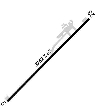
| Lat: N 3851.1 Long: W 08334.0 Elev: 896 Var: +04 Longest Runway: 3558 | ||
| CTAF: 122.8 | ||
| ||
| Rwy | Rwy | |||||||
| 3558x65 | 3558' | 3558x65 | 3558' | |||||
| Runway ID | Single Wheel | Double Wheel | Double Tandem Wheel | Dual Double Wheel |
| 05/23 | N/A | N/A | N/A | N/A |
| These numbers are Advisory and are not limits. The Airport Manager should have more accurate Weight Limits | ||||
 Airport Diagram might not be current. | |
| Facility Name: | ALEXANDER SALAMON |
| City Name: | WEST UNION |
| County: | ADAMS |
| State abbrev: | OH |
| State Name: | OHIO |
| Ownership: | PUBLICLY OWNED |
| Use: | OPEN TO THE PUBLIC |
| Owner's Name: | ADAMS CO ARPT AUTH |
| Address: | ADAMS CO COURTHOUSE, 110 W MAIN ST |
| WEST UNION, OH 45693-1347 | |
| Owner's Phone: | 937-544-3286 |
| Manager's Name: | JASON GROOMS |
| Address: | 3399 CROSS RD |
| WINCHESTER, OH 45697-9477 | |
| Phone: | 513-550-2919 |
| FAA Region: | GREAT LAKES |
| FAA Field Office: | DET |
| Date | Sunrise | Sunset |
|---|---|---|
| 04/25/24 Thursday | 6:43 | 20:22 |
| 04/26/24 Friday | 6:42 | 20:23 |
| 04/27/24 Saturday | 6:41 | 20:24 |
| 04/28/24 Sunday | 6:39 | 20:25 |
| 04/29/24 Monday | 6:38 | 20:26 |
| 04/30/24 Tuesday | 6:37 | 20:27 |
| 05/01/24 Wednesday | 6:36 | 20:27 |
| 05/02/24 Thursday | 6:34 | 20:28 |
| 05/03/24 Friday | 6:33 | 20:29 |
| 05/04/24 Saturday | 6:32 | 20:30 |
| 05/05/24 Sunday | 6:31 | 20:31 |
| 05/06/24 Monday | 6:30 | 20:32 |
| 05/07/24 Tuesday | 6:29 | 20:33 |
| 05/08/24 Wednesday | 6:28 | 20:34 |
| Airport Attendance Schedule | MON-FRI IREG, SAT-SUN UNATNDD |
| Airport Status | OPERATIONAL (This Status can change at any time - please check NOTAMS) |
| Airport Lighting Schedule | ACTVT REIL RWY 05 & 23; PAPI RWY 23; MIRL RWY 05/23 - CTAF. |
| Airport Storage Available | Tie Downs |
| Extra Services Available | NONE |
| Wind Indicator | YES - (lighted) |
| Control Tower | NO |
| CTAF Frequency | 122.800 |
| Unicom Frequency | 122.800 |
| Rotating Beacon Color | WG |
| Segmented Circle | NO |
| Landing Fee | NO |
| Airport Inspected | STATE - performed by STATE AERONAUTICAL PERSONNEL |
| Inspection Date | 09/07/2021 |
| Type of Fuel Available | None |
| Airframe Repair Service | None |
| Power Plant Repair Service | None |
| Latitude | N3851.1 |
| Longitude | W08334.0 (ESTIMATED) |
| Arpt Elevation | 896ft (SURVEYED) |
| Magnetic Variation | 04W |
| 4 miles NW | of WEST UNION |
| Traffic Pattern Altitude | |
| Sectional Chart | CINCINNATI |
| Operations (Reported) | Yearly | Avg. Daily |
|---|---|---|
| General Aviation Transient | 72 | 0 |
| General Aviation Local | 1344 | 4 |
| Air Taxi | 0 | 0 |
| Commerical | 0 | 0 |
| Commuter | 0 | 0 |
| Military | 0 | 0 |
| Aircraft based on Field | |
|---|---|
| General Aviation Singles | 16 |
| General Aviation Multi | 0 |
| Jet Aircraft | 0 |
| General Aviation Helicopters | 0 |
| Military Aircraft | 0 |
| Gliders | 0 |
| Ultralights | 0 |
| FSS on field | NO |
| FSS tie-in | DAYTON |
| FSS Phone | 1-800-WX-BRIEF |
| Who issues Notams | DAY |
| Notam D service at airport | YES |
| ARTCC Name | INDIANAPOLIS |
| Airport Certification | |
| Aircraft Rescue & Firefighting Index | None |
| Airport of Entry | No |
| Custom Landing Rights | No |
| Joint Civil/Military | No |
| Military Landing rights | No |
| NATIONAL PLAN OF INTEGRATED AIRPORT SYSTEMS (NPIAS) |
| THIS AIRPORT HAS BEEN SURVEYED BY THE NATIONAL GEODETIC SURVEY. |
| TWY MKD WITH REFLECTORS. |
| DEER, BIRDS, & OTR WILDLIFE ON & INVOF ARPT. |
| FOR CD CTC INDIANAPOLIS ARTCC AT 317-247-2411. |
Airport Communications & Frequencies:
| |||||||||
| Runway: 05 | Runway: 23 | ||
| Mag heading: | 49° | Mag heading: | 229° |
| Rwy Slope: | .37% Up | Rwy Slope: | -.37% Down |
| Approach: | Approach: | ||
| Pattern: | Left Traffic | Pattern: | Left Traffic |
| Markings: | NONPRECISION INSTRUMENT | Markings: | NONPRECISION INSTRUMENT |
| Marking Condition: | POOR; FADED. | Marking Condition: | POOR; FADED. |
| Arresting Dev: | Arresting Dev: | ||
| Lat & Long: | N3850.9 W08334.2 | Lat. & Long.: | N3851.3 W08333.7 |
| Elev: | 882.9 ft. MSL | Elev: | 896.0 ft. MSL |
| TCH: | TCH: | 25 ft. AGL | |
| Visual Glide Path: | Visual Glide Path: | 3.30 degrees | |
| Displaced Threshold: | No | Displaced Threshold: | No |
| Touchdown Zone: | YES | Touchdown Zone: | YES |
| Touchdown Elev.: | 890.4 feet | Touchdown Elev.: | 896.0 feet |
| Visual Glide Slope: | Visual Glide Slope: | 4-Light PAPI on LEFT side of Runway | |
| RVR Equipment: | RVR Equipment: | ||
| RVV Equipment: | NO | RVV Equipment: | NO |
| Approach Lights: | Approach Lights: | ||
| REIL: | YES | REIL: | YES |
| Centerline Lights: | NO | Centerline Lights: | NO |
| Touchdown lights: | NO | Touchdown lights: | NO |
| Runway Category: | Runway with a Non-precision Approach | Runway Category: | Runway with a Non-precision Approach |
| Declared Distances: | Declared Distances: | ||
| Obstructions: | TREES; ALSO +255 FT HILL/TREES, 3000 FT DIST, 250 FT L, 10:1. | Obstructions: | BRUSH; ALSO +65 FT TREES, 1450 FT DIST, 180 FT L, 19:1. |
| Marked: | NOT Marked/Lighted | Marked: | NOT Marked/Lighted |
| Clearance slope: | 1:1 | Clearance slope: | 1:1 |
| Obstruction height: | 20 feet AGL | Obstruction height: | 10 feet AGL |
| Dist. from runway: | 201 feet | Dist. from runway: | 201 feet |
| Centerline offset: | 215 left of centerline | Centerline offset: | 200 feet left of centerline |
| Comments: | +5 FT FENCE, 0-200 FT DIST, 210 FT L/R; +15-20 FT BRUSH/TREES, 0-200 FT DIST, 215 FT L. | Comments: | +5 FT FENCE, 0-200 FT DIST, 200 FT L; +5-15 FT BRUSH, 0-200 FT DIST, 200 FT L. |
Thanks for using FltPlan.com
all rights reserved © 1999-2024 by Flight Plan LLC
