| ABERDEEN RGNL ABERDEEN SD |
| |
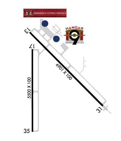
| Lat: N 4526.8 Long: W 09825.3 Elev: 1302 Var: -07 Longest Runway: 6901 | ||
| AWOS: 125.87 CTAF: 122.7 | ||
| |||||||||||||||||||||||||||||||||||||||||||||||||||||||||||||||||||||
| |||||||||||||||||||||||||||||||||||||||||||||||||||||||||||||||||||||
| |||||||||||||||||||||||||||||||||||||||||||||||||||||||||||||||||||||
| |||||||||||||||||||||||||||||||||||||||||||||||||||||||||||||||||||||
| |||||||||||||||||||||||||||||||||||||||||||||||||||||||||||||||||||||
| FBOs at nearby airports who want your business: | |||||||||||||||||
| |||||||||||||||||
| Rwy | Rwy | |||||||
| 6901x100 | 6901' | 6901x100 | 6901' | 109.90 - 308° | ||||
| 5500x100 | 5500' | 5500x100 | 5500' | |||||
| Runway ID | Single Wheel | Double Wheel | Double Tandem Wheel | Dual Double Wheel |
| 13/31 | 120,000 | 195,000 | 339,000 | N/A |
| 17/35 | 63,000 | 82,000 | 139,000 | N/A |
| These numbers are Advisory and are not limits. The Airport Manager should have more accurate Weight Limits | ||||
 Airport Diagram might not be current. | |
| Facility Name: | ABERDEEN RGNL |
| City Name: | ABERDEEN |
| County: | BROWN |
| State abbrev: | SD |
| State Name: | SOUTH DAKOTA |
| Ownership: | PUBLICLY OWNED |
| Use: | OPEN TO THE PUBLIC |
| Owner's Name: | CITY OF ABERDEEN |
| Address: | 123 S LINCOLN ST |
| ABERDEEN, SD 57401-1420 | |
| Owner's Phone: | 605-626-7020 |
| Manager's Name: | RICH KROKEL |
| Address: | 4740 6TH AVENUE SE |
| ABERDEEN, SD 57401-4215 | |
| Phone: | 605-626-7020 |
| FAA Region: | GREAT LAKES |
| FAA Field Office: | DMA |
| Date | Sunrise | Sunset |
|---|---|---|
| 04/25/24 Thursday | 6:30 | 20:34 |
| 04/26/24 Friday | 6:28 | 20:35 |
| 04/27/24 Saturday | 6:27 | 20:36 |
| 04/28/24 Sunday | 6:25 | 20:38 |
| 04/29/24 Monday | 6:24 | 20:39 |
| 04/30/24 Tuesday | 6:22 | 20:40 |
| 05/01/24 Wednesday | 6:21 | 20:41 |
| 05/02/24 Thursday | 6:19 | 20:43 |
| 05/03/24 Friday | 6:18 | 20:44 |
| 05/04/24 Saturday | 6:16 | 20:45 |
| 05/05/24 Sunday | 6:15 | 20:46 |
| 05/06/24 Monday | 6:14 | 20:48 |
| 05/07/24 Tuesday | 6:12 | 20:49 |
| 05/08/24 Wednesday | 6:11 | 20:50 |
| Airport Attendance Schedule | MON-FRI 0330-2400L; FOR SVCS AFTER HRS CALL (605) 225-1384/8008 OR (605)725-4774 |
| Airport Status | OPERATIONAL (This Status can change at any time - please check NOTAMS) |
| Airport Lighting Schedule | MIRL RWY 17/35 & HIRL RWY 13/31 PRESET ON LOW INTST SS-2400; TO INCR INTST & ACTVT MALSR RWY 31; REIL RWYS 13, 17, & 35; AND PAPI RWY 13 - CTAF. |
| Airport Storage Available | Hanger |
| Extra Services Available | Air Freight, Crop Dusting, Air Ambulance, Charter, Flight Instruction, Aircraft Rental, Aircraft Sales |
| Wind Indicator | YES - (lighted) |
| Control Tower | NO |
| CTAF Frequency | 122.700 |
| Unicom Frequency | 122.700 |
| Rotating Beacon Color | WG |
| Segmented Circle | YES |
| Landing Fee | NO |
| Airport Inspected | FEDERAL - performed by FAA AIRPORTS FIELD PERSONNEL |
| Inspection Date | 06/01/2023 |
| Type of Fuel Available | Grade 100LL, JET A (freeze point -40C) |
| Airframe Repair Service | MAJOR |
| Power Plant Repair Service | MAJOR |
| Latitude | N4526.8 |
| Longitude | W09825.3 (ESTIMATED) |
| Arpt Elevation | 1301ft (SURVEYED) |
| Magnetic Variation | 07E |
| 2 miles E | of ABERDEEN |
| Traffic Pattern Altitude | |
| Sectional Chart | TWIN CITIES |
| Operations (Reported) | Yearly | Avg. Daily |
|---|---|---|
| General Aviation Transient | 26000 | 71 |
| General Aviation Local | 7200 | 20 |
| Air Taxi | 5000 | 14 |
| Commerical | 1486 | 4 |
| Commuter | 0 | 0 |
| Military | 60 | 0 |
| Aircraft based on Field | |
|---|---|
| General Aviation Singles | 42 |
| General Aviation Multi | 16 |
| Jet Aircraft | 7 |
| General Aviation Helicopters | 1 |
| Military Aircraft | 0 |
| Gliders | 0 |
| Ultralights | 0 |
| FSS on field | NO |
| FSS tie-in | HURON |
| FSS Phone | 1-800-WX-BRIEF |
| Who issues Notams | ABR |
| Notam D service at airport | YES |
| ARTCC Name | MINNEAPOLIS |
| Airport Certification | AIRPORT RECEIVING SCHEDULED AIR CARRIER SERVICE FROM CARRIERS CERTIFICATED BY THE CIVIL AERONAUTICS BOARD; PPR FOR UNSKED ACR OPNS WITH MORE THAN 30 PSGR SEATS CALL AMGR 605-626-7020. AFT HRS CALL 605-216-0321. |
| Aircraft Rescue & Firefighting Index | AIRPORT HAS A CERTIFICATE UNDER CFR PART 139 |
| Airport of Entry | No |
| Custom Landing Rights | No |
| Joint Civil/Military | No |
| Military Landing rights | YES |
| NATIONAL PLAN OF INTEGRATED AIRPORT SYSTEMS (NPIAS) |
| GRANT AGREEMENTS UNDER FAAP/ADAP/AIP |
| ASSURANCES PURSUANT TO TITLE VI, CIVIL RIGHTS ACT OF 1964 |
| BIRDS ON & INVOF ARPT. |
| ARPT NOT AVBL FOR INTL ARRIVALS. |
| SURFACE CONDITIONS NOT MONITORED 0000-0330L |
| FOR CD IF UNA TO CTC ON FSS FREQ, CTC MINNEAPOLIS ARTCC AT 651-463-5588. |
Airport Communications & Frequencies:
| |||||||||
| Runway: 13 | Runway: 31 | ||
| Mag heading: | 128° | Mag heading: | 308° |
| Rwy Slope: | -.01% Down | Rwy Slope: | .01% Up |
| Approach: | Approach: | ILS/DME | |
| Pattern: | Left Traffic | Pattern: | Left Traffic |
| Markings: | PRECISION INSTRUMENT | Markings: | PRECISION INSTRUMENT |
| Marking Condition: | GOOD | Marking Condition: | GOOD |
| Arresting Dev: | Arresting Dev: | ||
| Lat & Long: | N4527.3 W09825.7 | Lat. & Long.: | N4526.5 W09824.5 |
| Elev: | 1301.9 ft. MSL | Elev: | 1300.9 ft. MSL |
| TCH: | 50 ft. AGL | TCH: | 67 ft. AGL |
| Visual Glide Path: | 3.00 degrees | Visual Glide Path: | 3.00 degrees |
| Displaced Threshold: | No | Displaced Threshold: | No |
| Touchdown Zone: | YES | Touchdown Zone: | YES |
| Touchdown Elev.: | 1301.9 feet | Touchdown Elev.: | 1300.9 feet |
| Visual Glide Slope: | 4-Light PAPI on LEFT side of Runway | Visual Glide Slope: | 4-Light PAPI on LEFT side of Runway |
| RVR Equipment: | RVR Equipment: | ||
| RVV Equipment: | NO | RVV Equipment: | NO |
| Approach Lights: | Approach Lights: | MALSR - 1,400 foot medium intensity approach lighting system with runway alignment indicator lights | |
| REIL: | YES | REIL: | NO |
| Centerline Lights: | NO | Centerline Lights: | NO |
| Touchdown lights: | NO | Touchdown lights: | NO |
| Runway Category: | D | Runway Category: | Precision Instrument Runway |
| Declared Distances: | TORA:6901' TODA:6901' ASDA:6901' LDA:6901' | Declared Distances: | TORA:6901' TODA:6901' ASDA:6901' LDA:6901' |
| Runway: 17 | Runway: 35 | ||
| Mag heading: | 173° | Mag heading: | 353° |
| Rwy Slope: | -.03% Down | Rwy Slope: | .03% Up |
| Approach: | Approach: | ||
| Pattern: | Left Traffic | Pattern: | Left Traffic |
| Markings: | PRECISION INSTRUMENT | Markings: | PRECISION INSTRUMENT |
| Marking Condition: | GOOD | Marking Condition: | GOOD |
| Arresting Dev: | Arresting Dev: | ||
| Lat & Long: | N4527.1 W09825.6 | Lat. & Long.: | N4526.2 W09825.6 |
| Elev: | 1301.8 ft. MSL | Elev: | 1300.3 ft. MSL |
| TCH: | 40 ft. AGL | TCH: | 40 ft. AGL |
| Visual Glide Path: | 3.00 degrees | Visual Glide Path: | 3.00 degrees |
| Displaced Threshold: | No | Displaced Threshold: | No |
| Touchdown Zone: | YES | Touchdown Zone: | YES |
| Touchdown Elev.: | 1301.8 feet | Touchdown Elev.: | 1300.3 feet |
| Visual Glide Slope: | 4-Light PAPI on RIGHT side of Runway | Visual Glide Slope: | 4-Light PAPI on LEFT side of Runway |
| RVR Equipment: | RVR Equipment: | ||
| RVV Equipment: | NO | RVV Equipment: | NO |
| Approach Lights: | Approach Lights: | ||
| REIL: | YES | REIL: | YES |
| Centerline Lights: | NO | Centerline Lights: | NO |
| Touchdown lights: | NO | Touchdown lights: | NO |
| Runway Category: | D | Runway Category: | D |
| Declared Distances: | TORA:5500' TODA:5500' ASDA:5500' LDA:5500' | Declared Distances: | TORA:5500' TODA:5500' ASDA:5500' LDA:5500' |
Thanks for using FltPlan.com
all rights reserved © 1999-2024 by Flight Plan LLC