
| ABILENE RGNL ABILENE TX |
| |
| Lat: N 3224.7 Long: W 09940.9 Elev: 1791 Var: -05 Longest Runway: 7208 | ||
| Dept. ATIS: 118.25 Arr. ATIS: 118.25 Ground: 121.7 Tower: 120.1 | ||
| ||||||||||||||||||||||||||||||||||||||||||||
| ||||||||||||||||||||||||||||||||||||||||||||
| ||||||||||||||||||||||||||||||||||||||||||||
| ||||||||||||||||||||||||||||||||||||||||||||
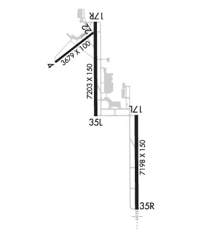
| Rwy | Rwy | |||||||
| 7198x150 | 7198' | 7198x150 | 7198' | 110.30 - 354° | ||||
| 7208x150 | 7208' | 109.75 - 174° | 7208x150 | 7208' | ||||
| Runway ID | Single Wheel | Double Wheel | Double Tandem Wheel | Dual Double Wheel |
| 17L/35R | 85,000 | 160,000 | 160,000 | N/A |
| 17R/35L | 85,000 | 160,000 | 160,000 | N/A |
| These numbers are Advisory and are not limits. The Airport Manager should have more accurate Weight Limits | ||||
 Airport Diagram might not be current. | |
| Facility Name: | ABILENE RGNL |
| City Name: | ABILENE |
| County: | TAYLOR |
| State abbrev: | TX |
| State Name: | TEXAS |
| Ownership: | PUBLICLY OWNED |
| Use: | OPEN TO THE PUBLIC |
| Owner's Name: | CITY OF ABILENE |
| Address: | PO BOX 60 |
| ABILENE, TX 79604 | |
| Owner's Phone: | 325-676-6206 |
| Manager's Name: | DON GREEN |
| Address: | 2933 AIRPORT BLVD SUITE 200 |
| ABILENE, TX 79602 | |
| Phone: | 325-676-6367 |
| FAA Region: | SOUTHWEST |
| FAA Field Office: | TEX |
| Date | Sunrise | Sunset |
|---|---|---|
| 04/24/24 Wednesday | 6:58 | 20:15 |
| 04/25/24 Thursday | 6:57 | 20:16 |
| 04/26/24 Friday | 6:56 | 20:17 |
| 04/27/24 Saturday | 6:55 | 20:18 |
| 04/28/24 Sunday | 6:54 | 20:18 |
| 04/29/24 Monday | 6:53 | 20:19 |
| 04/30/24 Tuesday | 6:52 | 20:20 |
| 05/01/24 Wednesday | 6:51 | 20:21 |
| 05/02/24 Thursday | 6:50 | 20:21 |
| 05/03/24 Friday | 6:50 | 20:22 |
| 05/04/24 Saturday | 6:49 | 20:23 |
| 05/05/24 Sunday | 6:48 | 20:23 |
| 05/06/24 Monday | 6:47 | 20:24 |
| 05/07/24 Tuesday | 6:46 | 20:25 |
| Airport Attendance Schedule | CONTINUOUS |
| Airport Status | OPERATIONAL (This Status can change at any time - please check NOTAMS) |
| Airport Lighting Schedule | SS-SR |
| Airport Storage Available | Tie Downs, Hanger |
| Extra Services Available | Air Freight, Avionics, Charter, Aircraft Sales |
| Wind Indicator | YES - (lighted) |
| Control Tower | YES |
| CTAF Frequency | |
| Unicom Frequency | 122.950 |
| Rotating Beacon Color | WG |
| Segmented Circle | YES |
| Landing Fee | NO |
| Airport Inspected | FEDERAL - performed by FAA AIRPORTS FIELD PERSONNEL |
| Inspection Date | 06/08/2023 |
| Type of Fuel Available | Grade 100LL, JET A (freeze point -40C), JET A-1 (icing inhibitor, freeze point -50C) |
| Airframe Repair Service | MAJOR |
| Power Plant Repair Service | MAJOR |
| Latitude | N3224.7 |
| Longitude | W09940.9 (ESTIMATED) |
| Arpt Elevation | 1790ft (SURVEYED) |
| Magnetic Variation | 05E |
| 3 miles SE | of ABILENE |
| Traffic Pattern Altitude | |
| Sectional Chart | DALLAS-FT WORTH |
| Operations (Reported) | Yearly | Avg. Daily |
|---|---|---|
| General Aviation Transient | 14773 | 40 |
| General Aviation Local | 7335 | 20 |
| Air Taxi | 5817 | 16 |
| Commerical | 1389 | 4 |
| Commuter | 0 | 0 |
| Military | 12145 | 33 |
| Aircraft based on Field | |
|---|---|
| General Aviation Singles | 79 |
| General Aviation Multi | 17 |
| Jet Aircraft | 8 |
| General Aviation Helicopters | 1 |
| Military Aircraft | 0 |
| Gliders | 0 |
| Ultralights | 0 |
| FSS on field | NO |
| FSS tie-in | FORT WORTH |
| FSS Phone | 1-800-WX-BRIEF |
| Who issues Notams | ABI |
| Notam D service at airport | YES |
| ARTCC Name | FORT WORTH |
| Airport Certification | AIRPORT RECEIVING SCHEDULED AIR CARRIER SERVICE FROM CARRIERS CERTIFICATED BY THE CIVIL AERONAUTICS BOARD; ABI IS ARFF INDEX B; ARFF INDEX C AVBL WITH PPR. |
| Aircraft Rescue & Firefighting Index | AIRPORT HAS A CERTIFICATE UNDER CFR PART 139 |
| Airport of Entry | No |
| Custom Landing Rights | No |
| Joint Civil/Military | No |
| Military Landing rights | YES |
| NATIONAL PLAN OF INTEGRATED AIRPORT SYSTEMS (NPIAS) |
| GRANT AGREEMENTS UNDER FAAP/ADAP/AIP |
| ASSURANCES PURSUANT TO TITLE VI, CIVIL RIGHTS ACT OF 1964 |
| UNCTLD ARPT 2 NM NE OF ARPT, PAT ALT 2300 FT. |
| MIL AVN SVCS AVBL AT ARPT. |
| RWY 04/22 PERMLY CLSD, NOT AVBL FOR ACFT OPNS. |
Airport Communications & Frequencies:
| ||||||||||||||||||||||||||||||||||||||||||
| Runway: 17L | Runway: 35R | ||
| Mag heading: | 175° | Mag heading: | 355° |
| Rwy Slope: | -.20% Down | Rwy Slope: | .20% Up |
| Approach: | Approach: | ILS/DME | |
| Pattern: | Left Traffic | Pattern: | Right Traffic |
| Markings: | PRECISION INSTRUMENT | Markings: | PRECISION INSTRUMENT |
| Marking Condition: | GOOD | Marking Condition: | GOOD |
| Arresting Dev: | Arresting Dev: | ||
| Lat & Long: | N3224.5 W09940.5 | Lat. & Long.: | N3223.3 W09940.5 |
| Elev: | 1790.6 ft. MSL | Elev: | 1775.9 ft. MSL |
| TCH: | 54 ft. AGL | TCH: | |
| Visual Glide Path: | 3.00 degrees | Visual Glide Path: | |
| Displaced Threshold: | No | Displaced Threshold: | No |
| Touchdown Zone: | YES | Touchdown Zone: | YES |
| Touchdown Elev.: | 1790.6 feet | Touchdown Elev.: | 1776.4 feet |
| Visual Glide Slope: | 4-Light PAPI on LEFT side of Runway | Visual Glide Slope: | |
| RVR Equipment: | ROLLOUT | RVR Equipment: | TOUCHDOWN |
| RVV Equipment: | NO | RVV Equipment: | NO |
| Approach Lights: | Approach Lights: | MALSR - 1,400 foot medium intensity approach lighting system with runway alignment indicator lights | |
| REIL: | NO | REIL: | NO |
| Centerline Lights: | NO | Centerline Lights: | NO |
| Touchdown lights: | NO | Touchdown lights: | NO |
| Runway Category: | Runway with a Non-precision Approach having visibility minimums greater than 3/4 mile | Runway Category: | Precision Instrument Runway |
| Declared Distances: | TORA:7198' TODA:7198' ASDA:7198' LDA:7198' | Declared Distances: | TORA:7198' TODA:7198' ASDA:7198' LDA:7198' |
| Obstructions: | GND | Obstructions: | |
| Marked: | NOT Marked/Lighted | Marked: | |
| Clearance slope: | Clearance slope: | 50:1 | |
| Obstruction height: | 2 feet AGL | Obstruction height: | |
| Dist. from runway: | 200 feet | Dist. from runway: | |
| Centerline offset: | Centerline offset: | ||
| Comments: | Comments: |
| Runway: 17R | Runway: 35L | ||
| Mag heading: | 175° | Mag heading: | 355° |
| Rwy Slope: | .38% Up | Rwy Slope: | -.38% Down |
| Approach: | LOC/DME | Approach: | |
| Pattern: | Right Traffic | Pattern: | Left Traffic |
| Markings: | NONPRECISION INSTRUMENT | Markings: | NONPRECISION INSTRUMENT |
| Marking Condition: | GOOD | Marking Condition: | GOOD |
| Arresting Dev: | Arresting Dev: | ||
| Lat & Long: | N3225.7 W09941.1 | Lat. & Long.: | N3224.5 W09941.1 |
| Elev: | 1758.4 ft. MSL | Elev: | 1786.1 ft. MSL |
| TCH: | 63 ft. AGL | TCH: | 54 ft. AGL |
| Visual Glide Path: | 3.00 degrees | Visual Glide Path: | 3.00 degrees |
| Displaced Threshold: | No | Displaced Threshold: | No |
| Touchdown Zone: | YES | Touchdown Zone: | YES |
| Touchdown Elev.: | 1771.2 feet | Touchdown Elev.: | 1786.2 feet |
| Visual Glide Slope: | 4-Light PAPI on LEFT side of Runway | Visual Glide Slope: | 4-Light PAPI on LEFT side of Runway |
| RVR Equipment: | RVR Equipment: | ||
| RVV Equipment: | NO | RVV Equipment: | NO |
| Approach Lights: | Approach Lights: | ||
| REIL: | NO | REIL: | YES |
| Centerline Lights: | NO | Centerline Lights: | NO |
| Touchdown lights: | NO | Touchdown lights: | NO |
| Runway Category: | Runway with a Non-precision Approach having visibility minimums greater than 3/4 mile | Runway Category: | Runway with a Visual Approach |
| Declared Distances: | TORA:7202' TODA:7202' ASDA:7202' LDA:7202' | Declared Distances: | TORA:7202' TODA:7202' ASDA:7202' LDA:7202' |
Thanks for using FltPlan.com
all rights reserved © 1999-2024 by Flight Plan LLC