
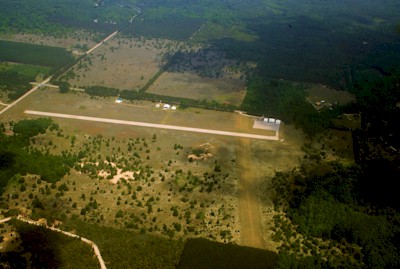
| THOMPSONVILLE THOMPSONVILLE MI |
| |
| Lat: N 4431.1 Long: W 08558.2 Elev: 793 Var: +04 Longest Runway: 2900 | ||
| CTAF: 122.9 | ||
| ||||||||||||||||||||||||||||||||
| ||||||||||||||||||||||||||||||||
| Rwy | Rwy | |||||||
| 2900x75 | 2840' | 2900x75 | 2900' | |||||
| 2475x150 | 1263' | 2475x150 | 1390' | |||||
| Runway ID | Single Wheel | Double Wheel | Double Tandem Wheel | Dual Double Wheel |
| 09/27 | N/A | 12,500 | N/A | N/A |
| 17/35 | N/A | N/A | N/A | N/A |
| These numbers are Advisory and are not limits. The Airport Manager should have more accurate Weight Limits | ||||
| FltPlan does not have IFR approach charts available for K7Y2. |
| Facility Name: | THOMPSONVILLE |
| City Name: | THOMPSONVILLE |
| County: | BENZIE |
| State abbrev: | MI |
| State Name: | MICHIGAN |
| Ownership: | PUBLICLY OWNED |
| Use: | OPEN TO THE PUBLIC |
| Owner's Name: | VILLAGE OF THOMPSONVILLE |
| Address: | 14714 LINCOLN AVE |
| THOMPSONVILLE, MI 49683-9109 | |
| Owner's Phone: | 231-378-2575 |
| Manager's Name: | MARV PREPEJCHAL |
| Address: | 20266 VALENCOURT RD |
| COPEMISH, MI 49625-9735 | |
| Phone: | 231-649-3802; CELL. RES 231-378-2435. |
| FAA Region: | GREAT LAKES |
| FAA Field Office: | DET |
| Date | Sunrise | Sunset |
|---|---|---|
| 04/25/24 Thursday | 6:42 | 20:42 |
| 04/26/24 Friday | 6:41 | 20:43 |
| 04/27/24 Saturday | 6:39 | 20:44 |
| 04/28/24 Sunday | 6:38 | 20:46 |
| 04/29/24 Monday | 6:36 | 20:47 |
| 04/30/24 Tuesday | 6:35 | 20:48 |
| 05/01/24 Wednesday | 6:33 | 20:49 |
| 05/02/24 Thursday | 6:32 | 20:50 |
| 05/03/24 Friday | 6:30 | 20:52 |
| 05/04/24 Saturday | 6:29 | 20:53 |
| 05/05/24 Sunday | 6:28 | 20:54 |
| 05/06/24 Monday | 6:26 | 20:55 |
| 05/07/24 Tuesday | 6:25 | 20:56 |
| 05/08/24 Wednesday | 6:24 | 20:58 |
| Airport Attendance Schedule | UNATTENDED |
| Airport Status | OPERATIONAL (This Status can change at any time - please check NOTAMS) |
| Airport Lighting Schedule | ACTVT PAPI RWY 27; LIRL RWY 09/27 - 5 CLICKS CTAF (3 CLICKS OFF). |
| Airport Storage Available | Tie Downs |
| Extra Services Available | NONE |
| Wind Indicator | YES - (lighted) |
| Control Tower | NO |
| CTAF Frequency | 122.900 |
| Unicom Frequency | |
| Rotating Beacon Color | WG; ARPT ROTG BCN ON SKI HILL, 450 FT ABV ARPT ELEV, 1.0 MI NW. |
| Segmented Circle | YES |
| Landing Fee | NO |
| Airport Inspected | STATE - performed by STATE AERONAUTICAL PERSONNEL |
| Inspection Date | 10/18/2021 |
| Type of Fuel Available | None |
| Airframe Repair Service | None |
| Power Plant Repair Service | None |
| Latitude | N4431.1 |
| Longitude | W08558.2 (ESTIMATED) |
| Arpt Elevation | 793ft (SURVEYED) |
| Magnetic Variation | 04W |
| 2 miles W | of THOMPSONVILLE |
| Traffic Pattern Altitude | |
| Sectional Chart | GREEN BAY |
| Operations (Reported) | Yearly | Avg. Daily |
|---|---|---|
| General Aviation Transient | 300 | 1 |
| General Aviation Local | 300 | 1 |
| Air Taxi | 0 | 0 |
| Commerical | 0 | 0 |
| Commuter | 0 | 0 |
| Military | 0 | 0 |
| Aircraft based on Field | |
|---|---|
| General Aviation Singles | 11 |
| General Aviation Multi | 0 |
| Jet Aircraft | 0 |
| General Aviation Helicopters | 0 |
| Military Aircraft | 0 |
| Gliders | 0 |
| Ultralights | 1 |
| FSS on field | NO |
| FSS tie-in | LANSING |
| FSS Phone | 1-800-WX-BRIEF |
| Who issues Notams | LAN |
| Notam D service at airport | YES |
| ARTCC Name | MINNEAPOLIS |
| Airport Certification | |
| Aircraft Rescue & Firefighting Index | None |
| Airport of Entry | No |
| Custom Landing Rights | No |
| Joint Civil/Military | No |
| Military Landing rights | No |
| +450 FT UNLGTD SKI HILL 1/2 MILE W OF ARPT. |
| ADMIN BLDG / RESTROOM ACCESS, 5-3-2-1. |
| FOR CD CTC MINNEAPOLIS ARTCC AT 651-463-5588. |
| RWY 17/3 5 CLSD TO TSNT ACFT CTC AMGR FOR DTLS; CLSD NOV-MAR & WHEN SNOW COVD. NO SNOW REMOVAL. |
| Runway: 09 | Runway: 27 | ||
| Mag heading: | N/A | Mag heading: | N/A |
| Rwy Slope: | .00% | Rwy Slope: | .00% |
| Approach: | Approach: | ||
| Pattern: | Right Traffic | Pattern: | Left Traffic |
| Markings: | BASIC | Markings: | BASIC |
| Marking Condition: | FAIR | Marking Condition: | FAIR |
| Arresting Dev: | Arresting Dev: | ||
| Lat & Long: | N4431.1 W08558.7 | Lat. & Long.: | N4431.1 W08558.0 |
| Elev: | 793.0 ft. MSL | Elev: | 793.0 ft. MSL |
| TCH: | TCH: | 20 ft. AGL | |
| Visual Glide Path: | Visual Glide Path: | 4.00 degrees | |
| Displaced Threshold: | 60 feet | Displaced Threshold: | No |
| Touchdown Zone: | NO | Touchdown Zone: | NO |
| Touchdown Elev.: | Touchdown Elev.: | ||
| Visual Glide Slope: | Visual Glide Slope: | 2-Light PAPI on LEFT side of Runway | |
| RVR Equipment: | RVR Equipment: | ||
| RVV Equipment: | NO | RVV Equipment: | NO |
| Approach Lights: | Approach Lights: | ||
| REIL: | NO | REIL: | NO |
| Centerline Lights: | NO | Centerline Lights: | NO |
| Touchdown lights: | NO | Touchdown lights: | NO |
| Runway Category: | Runway with a Visual Approach | Runway Category: | Runway with a Visual Approach |
| Declared Distances: | Declared Distances: | ||
| Obstructions: | ROAD | Obstructions: | TREE |
| Marked: | NOT Marked/Lighted | Marked: | NOT Marked/Lighted |
| Clearance slope: | 2:1 | Clearance slope: | 3:1 |
| Obstruction height: | 14 feet AGL | Obstruction height: | 14 feet AGL |
| Dist. from runway: | 240 feet | Dist. from runway: | 250 feet |
| Centerline offset: | Centerline offset: | 125 feet right of centerline | |
| Comments: | + 4 FT FENCE, 185 FT DSTC L/R. | Comments: |
| Runway: 17 | Runway: 35 | ||
| Mag heading: | N/A | Mag heading: | N/A |
| Rwy Slope: | .00% | Rwy Slope: | .00% |
| Approach: | Approach: | ||
| Pattern: | Left Traffic | Pattern: | Right Traffic |
| Markings: | Markings: | ||
| Marking Condition: | RWY & DTHR MKD WITH 3 FT YELLOW CONES. | Marking Condition: | RWY & DTHR MKD WITH 3 FT YELLOW CONES. |
| Arresting Dev: | Arresting Dev: | ||
| Lat & Long: | N4431.2 W08558.1 | Lat. & Long.: | N4430.8 W08558.0 |
| Elev: | 793.0 ft. MSL | Elev: | 793.0 ft. MSL |
| TCH: | TCH: | ||
| Visual Glide Path: | Visual Glide Path: | ||
| Displaced Threshold: | 1212 feet | Displaced Threshold: | 1085 feet |
| Touchdown Zone: | NO | Touchdown Zone: | NO |
| Touchdown Elev.: | Touchdown Elev.: | ||
| Visual Glide Slope: | Visual Glide Slope: | ||
| RVR Equipment: | RVR Equipment: | ||
| RVV Equipment: | NO | RVV Equipment: | NO |
| Approach Lights: | Approach Lights: | ||
| REIL: | NO | REIL: | NO |
| Centerline Lights: | NO | Centerline Lights: | NO |
| Touchdown lights: | NO | Touchdown lights: | NO |
| Runway Category: | Runway with a Visual Approach | Runway Category: | Runway with a Visual Approach |
| Declared Distances: | Declared Distances: | ||
| Obstructions: | TREES | Obstructions: | TREES |
| Marked: | NOT Marked/Lighted | Marked: | NOT Marked/Lighted |
| Clearance slope: | APCH RATIO 15:1 TO DTHR. | Clearance slope: | APCH RATIO 15:1 TO DTHR. |
| Obstruction height: | 70 feet AGL | Obstruction height: | 75 feet AGL |
| Dist. from runway: | 50 feet | Dist. from runway: | 40 feet |
| Centerline offset: | 75 right of centerline | Centerline offset: | |
| Comments: | Comments: |
Thanks for using FltPlan.com
all rights reserved © 1999-2024 by Flight Plan LLC