
| FORT BENTON FORT BENTON MT |
| |
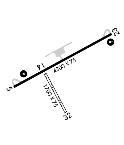
| Lat: N 4750.7 Long: W 11038.2 Elev: 2869 Var: -14 Longest Runway: 4300 | ||
| Clr Del: 801-320-2568 AWOS: 122.8 CTAF: 122.8 | ||
| ||||||||||||||||||||||||||||||||
| ||||||||||||||||||||||||||||||||
| ||||||||||||||||||||||||||||||||
| Rwy | Rwy | |||||||
| 4300x75 | 4300' | 4300x75 | 4300' | |||||
| 1700x75 | 1700' | 1700x75 | 1700' | |||||
| Runway ID | Single Wheel | Double Wheel | Double Tandem Wheel | Dual Double Wheel |
| 05/23 | 16,000 | N/A | N/A | N/A |
| 14/32 | N/A | N/A | N/A | N/A |
| These numbers are Advisory and are not limits. The Airport Manager should have more accurate Weight Limits | ||||
 Airport Diagram might not be current. | |
| Facility Name: | FORT BENTON |
| City Name: | FORT BENTON |
| County: | CHOUTEAU |
| State abbrev: | MT |
| State Name: | MONTANA |
| Ownership: | PUBLICLY OWNED |
| Use: | OPEN TO THE PUBLIC |
| Owner's Name: | FT BENTON & CHOUTEAU CO |
| Address: | CHOUTEAU COUNTY COURTHOUSE, PO BOX 459 |
| FORT BENTON, MT 59442 | |
| Owner's Phone: | 406-622-9494 |
| Manager's Name: | MIKE MAY; OR CONTACT ANDY TAYLOR @ 406-622-5682. |
| Address: | PO BOX 1512, COLONY BAY ROAD |
| FORT BENTON, MT 59442 | |
| Phone: | (406) 781-9478 |
| FAA Region: | NORTHWEST MOUNTAIN |
| FAA Field Office: | HLN |
| Date | Sunrise | Sunset |
|---|---|---|
| 04/25/24 Thursday | 6:13 | 20:28 |
| 04/26/24 Friday | 6:12 | 20:29 |
| 04/27/24 Saturday | 6:10 | 20:31 |
| 04/28/24 Sunday | 6:08 | 20:32 |
| 04/29/24 Monday | 6:07 | 20:34 |
| 04/30/24 Tuesday | 6:05 | 20:35 |
| 05/01/24 Wednesday | 6:03 | 20:36 |
| 05/02/24 Thursday | 6:02 | 20:38 |
| 05/03/24 Friday | 6:00 | 20:39 |
| 05/04/24 Saturday | 5:59 | 20:41 |
| 05/05/24 Sunday | 5:57 | 20:42 |
| 05/06/24 Monday | 5:56 | 20:43 |
| 05/07/24 Tuesday | 5:54 | 20:45 |
| 05/08/24 Wednesday | 5:53 | 20:46 |
| Airport Attendance Schedule | UNATTENDED |
| Airport Status | OPERATIONAL (This Status can change at any time - please check NOTAMS) |
| Airport Lighting Schedule | ACTVT PAPI RWY 05 & 23; MIRL RWY 05/23 - CTAF. |
| Airport Storage Available | Tie Downs |
| Extra Services Available | Crop Dusting, Flight Instruction, Annual Surveying |
| Wind Indicator | YES - (lighted) |
| Control Tower | NO |
| CTAF Frequency | 122.800 |
| Unicom Frequency | 122.800 |
| Rotating Beacon Color | WG |
| Segmented Circle | YES |
| Landing Fee | NO |
| Airport Inspected | STATE - performed by STATE AERONAUTICAL PERSONNEL |
| Inspection Date | 07/24/2023 |
| Type of Fuel Available | Grade 100LL |
| Airframe Repair Service | NONE |
| Power Plant Repair Service | NONE |
| Latitude | N4750.7 |
| Longitude | W11038.2 (ESTIMATED) |
| Arpt Elevation | 2868ft (ESTIMATED) |
| Magnetic Variation | 14E |
| 1 miles NE | of FORT BENTON |
| Traffic Pattern Altitude | |
| Sectional Chart | GREAT FALLS |
| Operations (Reported) | Yearly | Avg. Daily |
|---|---|---|
| General Aviation Transient | 1650 | 5 |
| General Aviation Local | 3800 | 10 |
| Air Taxi | 0 | 0 |
| Commerical | 0 | 0 |
| Commuter | 0 | 0 |
| Military | 0 | 0 |
| Aircraft based on Field | |
|---|---|
| General Aviation Singles | 24 |
| General Aviation Multi | 4 |
| Jet Aircraft | 0 |
| General Aviation Helicopters | 2 |
| Military Aircraft | 0 |
| Gliders | 0 |
| Ultralights | 0 |
| FSS on field | NO |
| FSS tie-in | GREAT FALLS |
| FSS Phone | 1-800-WX-BRIEF |
| Who issues Notams | GTF |
| Notam D service at airport | YES |
| ARTCC Name | SALT LAKE CITY |
| Airport Certification | |
| Aircraft Rescue & Firefighting Index | None |
| Airport of Entry | No |
| Custom Landing Rights | No |
| Joint Civil/Military | No |
| Military Landing rights | YES |
| NATIONAL PLAN OF INTEGRATED AIRPORT SYSTEMS (NPIAS) |
| GRANT AGREEMENTS UNDER FAAP/ADAP/AIP |
| ASSURANCES PURSUANT TO TITLE VI, CIVIL RIGHTS ACT OF 1964 |
| FOR CD CTC SALT LAKE ARTCC AT 801-320-2568. |
| (PAY PHONE) PAY PHONE AVAILABLE. |
Airport Communications & Frequencies:
| |||||||||
| Runway: 05 | Runway: 23 | ||
| Mag heading: | 48° | Mag heading: | 228° |
| Rwy Slope: | -.22% Down | Rwy Slope: | .22% Up |
| Approach: | Approach: | ||
| Pattern: | Left Traffic | Pattern: | Left Traffic |
| Markings: | NONPRECISION INSTRUMENT | Markings: | NONPRECISION INSTRUMENT |
| Marking Condition: | GOOD | Marking Condition: | GOOD |
| Arresting Dev: | Arresting Dev: | ||
| Lat & Long: | N4750.5 W11038.7 | Lat. & Long.: | N4750.9 W11037.7 |
| Elev: | 2868.8 ft. MSL | Elev: | 2859.5 ft. MSL |
| TCH: | 40 ft. AGL | TCH: | 40 ft. AGL |
| Visual Glide Path: | 3.00 degrees | Visual Glide Path: | 3.00 degrees |
| Displaced Threshold: | No | Displaced Threshold: | No |
| Touchdown Zone: | YES | Touchdown Zone: | YES |
| Touchdown Elev.: | 2868.8 feet | Touchdown Elev.: | 2864.1 feet |
| Visual Glide Slope: | 2-Light PAPI on LEFT side of Runway | Visual Glide Slope: | 2-Light PAPI on LEFT side of Runway |
| RVR Equipment: | RVR Equipment: | ||
| RVV Equipment: | NO | RVV Equipment: | NO |
| Approach Lights: | Approach Lights: | ||
| REIL: | NO | REIL: | NO |
| Centerline Lights: | NO | Centerline Lights: | NO |
| Touchdown lights: | NO | Touchdown lights: | NO |
| Runway Category: | Runway with a Visual Approach | Runway Category: | Runway with a Non-precision Approach having visibility minimums greater than 3/4 mile |
| Declared Distances: | Declared Distances: |
| Runway: 14 | Runway: 32 | ||
| Mag heading: | 138° | Mag heading: | 318° |
| Rwy Slope: | .19% Up | Rwy Slope: | -.19% Down |
| Approach: | Approach: | ||
| Pattern: | Left Traffic | Pattern: | Left Traffic |
| Markings: | Markings: | ||
| Marking Condition: | Marking Condition: | ||
| Arresting Dev: | Arresting Dev: | ||
| Lat & Long: | N4750.6 W11038.4 | Lat. & Long.: | N4750.4 W11038.2 |
| Elev: | 2863.2 ft. MSL | Elev: | 2866.4 ft. MSL |
| TCH: | TCH: | ||
| Visual Glide Path: | Visual Glide Path: | ||
| Displaced Threshold: | No | Displaced Threshold: | No |
| Touchdown Zone: | YES | Touchdown Zone: | YES |
| Touchdown Elev.: | 2866.4 feet | Touchdown Elev.: | 2866.4 feet |
| Visual Glide Slope: | Visual Glide Slope: | ||
| RVR Equipment: | RVR Equipment: | ||
| RVV Equipment: | NO | RVV Equipment: | NO |
| Approach Lights: | Approach Lights: | ||
| REIL: | NO | REIL: | NO |
| Centerline Lights: | NO | Centerline Lights: | NO |
| Touchdown lights: | NO | Touchdown lights: | NO |
| Runway Category: | Runway with a Visual Approach | Runway Category: | Runway with a Visual Approach |
| Declared Distances: | Declared Distances: | ||
| Obstructions: | PLINE | Obstructions: | |
| Marked: | NOT Marked/Lighted | Marked: | |
| Clearance slope: | 16:1 | Clearance slope: | 20:1 |
| Obstruction height: | 50 feet AGL | Obstruction height: | |
| Dist. from runway: | 830 feet | Dist. from runway: | |
| Centerline offset: | Centerline offset: | ||
| Comments: | Comments: |
Thanks for using FltPlan.com
all rights reserved © 1999-2024 by Flight Plan LLC
