
| MARIANNA/LEE COUNTY AIRPORT MARIANNA AR |
| |
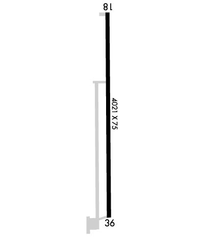
| Lat: N 3447.0 Long: W 09048.6 Elev: 219 Var: -00 Longest Runway: 4021 | ||
| CTAF: 122.8 | ||
| ||||||||||||||||||||||||||||||||||||||||||||
| ||||||||||||||||||||||||||||||||||||||||||||
| Rwy | Rwy | |||||||
| 4021x75 | 4021' | 4021x75 | 4021' | |||||
| Runway ID | Single Wheel | Double Wheel | Double Tandem Wheel | Dual Double Wheel |
| 18/36 | N/A | N/A | N/A | N/A |
| These numbers are Advisory and are not limits. The Airport Manager should have more accurate Weight Limits | ||||
 Airport Diagram might not be current. | |
| Facility Name: | MARIANNA/LEE COUNTY-STEVE EDWARDS FLD |
| City Name: | MARIANNA |
| County: | LEE |
| State abbrev: | AR |
| State Name: | ARKANSAS |
| Ownership: | PUBLICLY OWNED |
| Use: | OPEN TO THE PUBLIC |
| Owner's Name: | CITY OF MARIANNA |
| Address: | 35 SOUTH POPLAR |
| MARIANNA, AR 72360 | |
| Owner's Phone: | 870-295-6089 |
| Manager's Name: | DOUG GIBSON |
| Address: | BOX 478 |
| MARIANNA, AR 72360 | |
| Phone: | 870-295-3485 |
| FAA Region: | SOUTHWEST |
| FAA Field Office: | AOK |
| Date | Sunrise | Sunset |
|---|---|---|
| 04/25/24 Thursday | 6:18 | 19:44 |
| 04/26/24 Friday | 6:17 | 19:45 |
| 04/27/24 Saturday | 6:16 | 19:46 |
| 04/28/24 Sunday | 6:15 | 19:47 |
| 04/29/24 Monday | 6:14 | 19:47 |
| 04/30/24 Tuesday | 6:13 | 19:48 |
| 05/01/24 Wednesday | 6:12 | 19:49 |
| 05/02/24 Thursday | 6:11 | 19:50 |
| 05/03/24 Friday | 6:10 | 19:51 |
| 05/04/24 Saturday | 6:09 | 19:51 |
| 05/05/24 Sunday | 6:08 | 19:52 |
| 05/06/24 Monday | 6:07 | 19:53 |
| 05/07/24 Tuesday | 6:06 | 19:54 |
| 05/08/24 Wednesday | 6:05 | 19:55 |
| Airport Attendance Schedule | MON-FRI DALGT, SAT SR-1200 |
| Airport Status | OPERATIONAL (This Status can change at any time - please check NOTAMS) |
| Airport Lighting Schedule | ACTVT REIL RWY 18 & 36; PAPI RWY 18 & 36; MIRL RWY 18/36 - CTAF. |
| Airport Storage Available | Tie Downs |
| Extra Services Available | Crop Dusting |
| Wind Indicator | YES - (lighted) |
| Control Tower | NO |
| CTAF Frequency | 122.800 |
| Unicom Frequency | 122.800 |
| Rotating Beacon Color | WG |
| Segmented Circle | YES |
| Landing Fee | NO |
| Airport Inspected | STATE - performed by STATE AERONAUTICAL PERSONNEL |
| Inspection Date | 01/04/2024 |
| Type of Fuel Available | Grade 100LL; -10FOR FUEL OTHER HRS CALL 870-295-3485. |
| Airframe Repair Service | None |
| Power Plant Repair Service | None |
| Latitude | N3447.0 |
| Longitude | W09048.6 (ESTIMATED) |
| Arpt Elevation | 219ft (SURVEYED) |
| Magnetic Variation | 00E |
| 3 miles W | of MARIANNA |
| Traffic Pattern Altitude | |
| Sectional Chart | MEMPHIS |
| Operations (Reported) | Yearly | Avg. Daily |
|---|---|---|
| General Aviation Transient | 4000 | 11 |
| General Aviation Local | 21000 | 58 |
| Air Taxi | 0 | 0 |
| Commerical | 0 | 0 |
| Commuter | 0 | 0 |
| Military | 50 | 0 |
| Aircraft based on Field | |
|---|---|
| General Aviation Singles | 9 |
| General Aviation Multi | 2 |
| Jet Aircraft | 0 |
| General Aviation Helicopters | 0 |
| Military Aircraft | 0 |
| Gliders | 0 |
| Ultralights | 0 |
| FSS on field | NO |
| FSS tie-in | JONESBORO |
| FSS Phone | 1-800-WX-BRIEF |
| Who issues Notams | JBR |
| Notam D service at airport | YES |
| ARTCC Name | MEMPHIS |
| Airport Certification | |
| Aircraft Rescue & Firefighting Index | None |
| Airport of Entry | No |
| Custom Landing Rights | No |
| Joint Civil/Military | No |
| Military Landing rights | No |
| NATIONAL PLAN OF INTEGRATED AIRPORT SYSTEMS (NPIAS) |
| RY 36 75 FT UNLGTD PLINE 2300 FT SOUTH OF THLD. |
| NUMEROUS AGRICULTURE OPS FEB-OCT. |
| FOR CD CTC MEMPHIS ARTCC AT 901-368-8453/8449. |
Airport Communications & Frequencies:
| |||||||||
| Runway: 18 | Runway: 36 | ||
| Mag heading: | 181° | Mag heading: | 1° |
| Rwy Slope: | .01% Up | Rwy Slope: | -.01% Down |
| Approach: | Approach: | ||
| Pattern: | Left Traffic | Pattern: | Left Traffic |
| Markings: | NONPRECISION INSTRUMENT | Markings: | NONPRECISION INSTRUMENT |
| Marking Condition: | FAIR | Marking Condition: | FAIR |
| Arresting Dev: | Arresting Dev: | ||
| Lat & Long: | N3447.3 W09048.6 | Lat. & Long.: | N3446.6 W09048.6 |
| Elev: | 218.6 ft. MSL | Elev: | 219.0 ft. MSL |
| TCH: | 52 ft. AGL | TCH: | 53 ft. AGL |
| Visual Glide Path: | 3.00 degrees | Visual Glide Path: | 3.00 degrees |
| Displaced Threshold: | No | Displaced Threshold: | No |
| Touchdown Zone: | YES | Touchdown Zone: | YES |
| Touchdown Elev.: | 219.1 feet | Touchdown Elev.: | 219.1 feet |
| Visual Glide Slope: | 2-Light PAPI on LEFT side of Runway | Visual Glide Slope: | 2-Light PAPI on LEFT side of Runway |
| RVR Equipment: | RVR Equipment: | ||
| RVV Equipment: | NO | RVV Equipment: | NO |
| Approach Lights: | Approach Lights: | ||
| REIL: | YES | REIL: | YES |
| Centerline Lights: | NO | Centerline Lights: | NO |
| Touchdown lights: | NO | Touchdown lights: | NO |
| Runway Category: | Runway with a Non-precision Approach | Runway Category: | Runway with a Non-precision Approach |
| Declared Distances: | Declared Distances: | ||
| Obstructions: | TREE | Obstructions: | TREE |
| Marked: | NOT Marked/Lighted | Marked: | NOT Marked/Lighted |
| Clearance slope: | 8:1 | Clearance slope: | 35:1 |
| Obstruction height: | 75 feet AGL | Obstruction height: | 30 feet AGL |
| Dist. from runway: | 825 feet | Dist. from runway: | 1250 feet |
| Centerline offset: | 500 right of centerline | Centerline offset: | 525 feet left of centerline |
| Comments: | Comments: |
Thanks for using FltPlan.com
all rights reserved © 1999-2024 by Flight Plan LLC
