
| HAZEN MUNI HAZEN AR |
| |
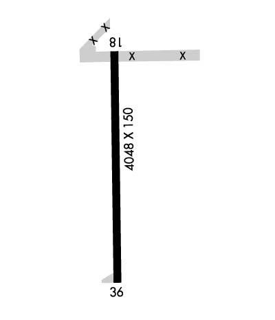
| Lat: N 3445.6 Long: W 09138.3 Elev: 230 Var: -03 Longest Runway: 4048 | ||
| CTAF: 122.8 | ||
| ||||||||||||||||||||||||||||||||||||||||||||
| ||||||||||||||||||||||||||||||||||||||||||||
| Rwy | Rwy | |||||||
| 4048x150 | 4048' | 4048x150 | 4048' | |||||
| Runway ID | Single Wheel | Double Wheel | Double Tandem Wheel | Dual Double Wheel |
| 18/36 | 12,000 | N/A | N/A | N/A |
| These numbers are Advisory and are not limits. The Airport Manager should have more accurate Weight Limits | ||||
| FltPlan does not have IFR approach charts available for K6M0. |
 Airport Diagram might not be current. | |
| Facility Name: | HAZEN MUNI DAVID DUCH FLD |
| City Name: | HAZEN |
| County: | PRAIRIE |
| State abbrev: | AR |
| State Name: | ARKANSAS |
| Ownership: | PUBLICLY OWNED |
| Use: | OPEN TO THE PUBLIC |
| Owner's Name: | CITY OF HAZEN |
| Address: | PO BOX 564 |
| HAZEN, AR 72064 | |
| Owner's Phone: | 870-255-4521 |
| Manager's Name: | PATRICK CLAYTON |
| Address: | 1856 HWY 249 |
| HAZEN, AR 72064 | |
| Phone: | 501-554-6590 |
| FAA Region: | SOUTHWEST |
| FAA Field Office: | AOK |
| Date | Sunrise | Sunset |
|---|---|---|
| 04/25/24 Thursday | 6:22 | 19:47 |
| 04/26/24 Friday | 6:21 | 19:48 |
| 04/27/24 Saturday | 6:20 | 19:49 |
| 04/28/24 Sunday | 6:18 | 19:50 |
| 04/29/24 Monday | 6:17 | 19:51 |
| 04/30/24 Tuesday | 6:16 | 19:51 |
| 05/01/24 Wednesday | 6:15 | 19:52 |
| 05/02/24 Thursday | 6:14 | 19:53 |
| 05/03/24 Friday | 6:13 | 19:54 |
| 05/04/24 Saturday | 6:12 | 19:55 |
| 05/05/24 Sunday | 6:11 | 19:55 |
| 05/06/24 Monday | 6:10 | 19:56 |
| 05/07/24 Tuesday | 6:09 | 19:57 |
| 05/08/24 Wednesday | 6:09 | 19:58 |
| Airport Attendance Schedule | 7 Days A Week DALGT; FOR SVC AFT HRS CALL 501-554-6590. |
| Airport Status | OPERATIONAL (This Status can change at any time - please check NOTAMS) |
| Airport Lighting Schedule | ACTVT MIRL RY 18/36 - CTAF. |
| Airport Storage Available | Tie Downs, Hanger |
| Extra Services Available | Crop Dusting |
| Wind Indicator | YES - (lighted) |
| Control Tower | NO |
| CTAF Frequency | 122.800 |
| Unicom Frequency | 122.800 |
| Rotating Beacon Color | WG |
| Segmented Circle | NO |
| Landing Fee | NO |
| Airport Inspected | STATE - performed by STATE AERONAUTICAL PERSONNEL |
| Inspection Date | 05/15/2023 |
| Type of Fuel Available | Grade 100LL; -10100LL AVBL 24 HRS SELF SERVE WITH CREDIT CARD. |
| Airframe Repair Service | MAJOR |
| Power Plant Repair Service | MAJOR |
| Latitude | N3445.6 |
| Longitude | W09138.3 (ESTIMATED) |
| Arpt Elevation | 230ft (SURVEYED) |
| Magnetic Variation | 03E |
| 3 miles SW | of HAZEN |
| Traffic Pattern Altitude | |
| Sectional Chart | MEMPHIS |
| Operations (Reported) | Yearly | Avg. Daily |
|---|---|---|
| General Aviation Transient | 2500 | 7 |
| General Aviation Local | 30000 | 82 |
| Air Taxi | 0 | 0 |
| Commerical | 0 | 0 |
| Commuter | 0 | 0 |
| Military | 600 | 2 |
| Aircraft based on Field | |
|---|---|
| General Aviation Singles | 13 |
| General Aviation Multi | 0 |
| Jet Aircraft | 0 |
| General Aviation Helicopters | 0 |
| Military Aircraft | 0 |
| Gliders | 0 |
| Ultralights | 0 |
| FSS on field | NO |
| FSS tie-in | JONESBORO |
| FSS Phone | 1-800-WX-BRIEF |
| Who issues Notams | JBR |
| Notam D service at airport | YES |
| ARTCC Name | MEMPHIS |
| Airport Certification | |
| Aircraft Rescue & Firefighting Index | None |
| Airport of Entry | No |
| Custom Landing Rights | No |
| Joint Civil/Military | No |
| Military Landing rights | YES |
| SURPLUS PROPERTY AGREEMENT UNDER REGULATION 16-WAA |
| EXTENSIVE AGRICULTURE OPNS JAN THRU SEPT. |
| MIGRATORY BIRDS INVOF ARPT OCT-MAR. |
| FOR CD CTC LITTLE ROCK APCH 501-379-2908 OR LITTLE ROCK ATCT 501-379-2911. |
| Runway: 18 | Runway: 36 | ||
| Mag heading: | N/A | Mag heading: | N/A |
| Rwy Slope: | -.13% Down | Rwy Slope: | .13% Up |
| Approach: | Approach: | ||
| Pattern: | Left Traffic | Pattern: | Left Traffic |
| Markings: | BASIC | Markings: | BASIC |
| Marking Condition: | GOOD | Marking Condition: | GOOD |
| Arresting Dev: | Arresting Dev: | ||
| Lat & Long: | N3445.9 W09138.3 | Lat. & Long.: | N3445.2 W09138.3 |
| Elev: | 229.7 ft. MSL | Elev: | 224.3 ft. MSL |
| TCH: | 52 ft. AGL | TCH: | 52 ft. AGL |
| Visual Glide Path: | 3.00 degrees | Visual Glide Path: | 3.00 degrees |
| Displaced Threshold: | No | Displaced Threshold: | No |
| Touchdown Zone: | NO | Touchdown Zone: | NO |
| Touchdown Elev.: | Touchdown Elev.: | ||
| Visual Glide Slope: | 2-Light PAPI on LEFT side of Runway | Visual Glide Slope: | 2-Light PAPI on LEFT side of Runway |
| RVR Equipment: | RVR Equipment: | ||
| RVV Equipment: | NO | RVV Equipment: | NO |
| Approach Lights: | Approach Lights: | ||
| REIL: | NO | REIL: | NO |
| Centerline Lights: | NO | Centerline Lights: | NO |
| Touchdown lights: | NO | Touchdown lights: | NO |
| Runway Category: | Runway with a Visual Approach | Runway Category: | Runway with a Visual Approach |
| Declared Distances: | Declared Distances: |
Thanks for using FltPlan.com
all rights reserved © 1999-2024 by Flight Plan LLC
