
| CREIGHTON MUNI CREIGHTON NE |
| |
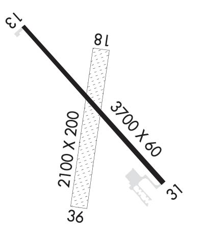
| Lat: N 4228.3 Long: W 09753.1 Elev: 1653 Var: -05 Longest Runway: 3700 | ||
| CTAF: 122.9 | ||
| ||||||||||||||||||||||||||||||||
| ||||||||||||||||||||||||||||||||
| Rwy | Rwy | |||||||
| 3700x60 | 3700' | 3700x60 | 3700' | |||||
| 2100x200 | 2100' | 2100x200 | 2100' | |||||
| Runway ID | Single Wheel | Double Wheel | Double Tandem Wheel | Dual Double Wheel |
| 13/31 | 12,000 | N/A | N/A | N/A |
| 18/36 | N/A | N/A | N/A | N/A |
| These numbers are Advisory and are not limits. The Airport Manager should have more accurate Weight Limits | ||||
 Airport Diagram might not be current. | |
| Facility Name: | CREIGHTON MUNI |
| City Name: | CREIGHTON |
| County: | KNOX |
| State abbrev: | NE |
| State Name: | NEBRASKA |
| Ownership: | PUBLICLY OWNED |
| Use: | OPEN TO THE PUBLIC |
| Owner's Name: | CREIGHTON AIRPORT AUTHORITY |
| Address: | PO BOX 188 |
| CREIGHTON, NE 68729-0188 | |
| Owner's Phone: | (402) 358-3557 |
| Manager's Name: | ROBERT BORGMANN; BOB BORGMANN, SECRETARY, CREIGHTON AIRPORT AUTHORITY. |
| Address: | P.O. BOX 51 |
| CREIGHTON, NE 68729-0051 | |
| Phone: | (402) 360-2916; MANAGER HOME PHONE 402-358-3343. |
| FAA Region: | CENTRAL |
| FAA Field Office: | NONE |
| Date | Sunrise | Sunset |
|---|---|---|
| 04/25/24 Thursday | 6:34 | 20:26 |
| 04/26/24 Friday | 6:32 | 20:27 |
| 04/27/24 Saturday | 6:31 | 20:28 |
| 04/28/24 Sunday | 6:30 | 20:29 |
| 04/29/24 Monday | 6:28 | 20:30 |
| 04/30/24 Tuesday | 6:27 | 20:31 |
| 05/01/24 Wednesday | 6:25 | 20:32 |
| 05/02/24 Thursday | 6:24 | 20:33 |
| 05/03/24 Friday | 6:23 | 20:35 |
| 05/04/24 Saturday | 6:21 | 20:36 |
| 05/05/24 Sunday | 6:20 | 20:37 |
| 05/06/24 Monday | 6:19 | 20:38 |
| 05/07/24 Tuesday | 6:18 | 20:39 |
| 05/08/24 Wednesday | 6:17 | 20:40 |
| Airport Attendance Schedule | UNATTENDED |
| Airport Status | OPERATIONAL (This Status can change at any time - please check NOTAMS) |
| Airport Lighting Schedule | DUSK-2300. FOR MIRL RY 13/31 AFT 2300 ACTVT - CTAF. ACTVT PAPI RY 13-31 - CTAF. |
| Airport Storage Available | Tie Downs, Hanger |
| Extra Services Available | Crop Dusting |
| Wind Indicator | YES - (lighted) |
| Control Tower | NO |
| CTAF Frequency | 122.900 |
| Unicom Frequency | |
| Rotating Beacon Color | WG |
| Segmented Circle | YES |
| Landing Fee | NO |
| Airport Inspected | STATE - performed by STATE AERONAUTICAL PERSONNEL |
| Inspection Date | 06/28/2022 |
| Type of Fuel Available | Grade 100LL; -10SELF SVR CC 24 HR |
| Airframe Repair Service | NONE |
| Power Plant Repair Service | NONE |
| Latitude | N4228.3 |
| Longitude | W09753.1 (ESTIMATED) |
| Arpt Elevation | 1653ft (SURVEYED) |
| Magnetic Variation | 05E |
| 1 miles E | of CREIGHTON |
| Traffic Pattern Altitude | |
| Sectional Chart | OMAHA |
| Operations (Reported) | Yearly | Avg. Daily |
|---|---|---|
| General Aviation Transient | 200 | 1 |
| General Aviation Local | 2120 | 6 |
| Air Taxi | 0 | 0 |
| Commerical | 0 | 0 |
| Commuter | 0 | 0 |
| Military | 0 | 0 |
| Aircraft based on Field | |
|---|---|
| General Aviation Singles | 11 |
| General Aviation Multi | 0 |
| Jet Aircraft | 0 |
| General Aviation Helicopters | 0 |
| Military Aircraft | 0 |
| Gliders | 0 |
| Ultralights | 0 |
| FSS on field | NO |
| FSS tie-in | COLUMBUS |
| FSS Phone | 1-800-WX-BRIEF |
| Who issues Notams | OLU |
| Notam D service at airport | YES |
| ARTCC Name | MINNEAPOLIS |
| Airport Certification | |
| Aircraft Rescue & Firefighting Index | None |
| Airport of Entry | No |
| Custom Landing Rights | No |
| Joint Civil/Military | No |
| Military Landing rights | YES |
| NATIONAL PLAN OF INTEGRATED AIRPORT SYSTEMS (NPIAS) |
| GRANT AGREEMENTS UNDER FAAP/ADAP/AIP |
| ASSURANCES PURSUANT TO TITLE VI, CIVIL RIGHTS ACT OF 1964 |
| FOR CD CTC MINNEAPOLIS ARTCC AT 651-463-5588. |
Airport Communications & Frequencies:
| |||||||
| Runway: 13 | Runway: 31 | ||
| Mag heading: | 125° | Mag heading: | 305° |
| Rwy Slope: | .06% Up | Rwy Slope: | -.06% Down |
| Approach: | Approach: | ||
| Pattern: | Left Traffic | Pattern: | Left Traffic |
| Markings: | NONPRECISION INSTRUMENT | Markings: | NONPRECISION INSTRUMENT |
| Marking Condition: | GOOD | Marking Condition: | GOOD |
| Arresting Dev: | Arresting Dev: | ||
| Lat & Long: | N4228.5 W09753.4 | Lat. & Long.: | N4228.1 W09752.8 |
| Elev: | 1641.8 ft. MSL | Elev: | 1644.0 ft. MSL |
| TCH: | 40 ft. AGL | TCH: | 40 ft. AGL |
| Visual Glide Path: | 3.00 degrees | Visual Glide Path: | 3.00 degrees |
| Displaced Threshold: | No | Displaced Threshold: | No |
| Touchdown Zone: | YES | Touchdown Zone: | YES |
| Touchdown Elev.: | 1646.6 feet | Touchdown Elev.: | 1646.6 feet |
| Visual Glide Slope: | 2-Light PAPI on LEFT side of Runway | Visual Glide Slope: | 2-Light PAPI on LEFT side of Runway |
| RVR Equipment: | RVR Equipment: | ||
| RVV Equipment: | NO | RVV Equipment: | NO |
| Approach Lights: | Approach Lights: | ||
| REIL: | NO | REIL: | NO |
| Centerline Lights: | NO | Centerline Lights: | NO |
| Touchdown lights: | NO | Touchdown lights: | NO |
| Runway Category: | Runway with a Non-precision Approach | Runway Category: | Runway with a Non-precision Approach |
| Declared Distances: | Declared Distances: | ||
| Comments: | CROPS AT END OF RWY. | Comments: | CROPS AT END OF RWY. |
| Runway: 18 | Runway: 36 | ||
| Mag heading: | 185° | Mag heading: | 5° |
| Rwy Slope: | -1.19% Down | Rwy Slope: | 1.19% Up |
| Approach: | Approach: | ||
| Pattern: | Left Traffic | Pattern: | Left Traffic |
| Markings: | Markings: | ||
| Marking Condition: | Marking Condition: | ||
| Arresting Dev: | Arresting Dev: | ||
| Lat & Long: | N4228.4 W09753.0 | Lat. & Long.: | N4228.1 W09753.1 |
| Elev: | 1653.0 ft. MSL | Elev: | 1628.0 ft. MSL |
| TCH: | TCH: | ||
| Visual Glide Path: | Visual Glide Path: | ||
| Displaced Threshold: | No | Displaced Threshold: | No |
| Touchdown Zone: | YES | Touchdown Zone: | YES |
| Touchdown Elev.: | 1653.0 feet | Touchdown Elev.: | 1653.0 feet |
| Visual Glide Slope: | Visual Glide Slope: | ||
| RVR Equipment: | RVR Equipment: | ||
| RVV Equipment: | NO | RVV Equipment: | NO |
| Approach Lights: | Approach Lights: | ||
| REIL: | NO | REIL: | NO |
| Centerline Lights: | NO | Centerline Lights: | NO |
| Touchdown lights: | NO | Touchdown lights: | NO |
| Runway Category: | Runway with a Visual Approach | Runway Category: | Runway with a Visual Approach |
| Declared Distances: | Declared Distances: | ||
| Obstructions: | TREE | Obstructions: | ROAD |
| Marked: | NOT Marked/Lighted | Marked: | NOT Marked/Lighted |
| Clearance slope: | 7:1 | Clearance slope: | 21:1 |
| Obstruction height: | 33 feet AGL | Obstruction height: | 15 feet AGL |
| Dist. from runway: | 249 feet; OBSTN LCTD 150 FT L OF RWY CNTRLN EXTDD. | Dist. from runway: | 320 feet; OBSTN LCTD EITHER SIDE OF RWY CNTRLN EXTDD. |
| Centerline offset: | 150 left of centerline | Centerline offset: | |
| Comments: | Comments: |
Thanks for using FltPlan.com
all rights reserved © 1999-2024 by Flight Plan LLC
