
| TITUSVILLE TITUSVILLE PA |
| |
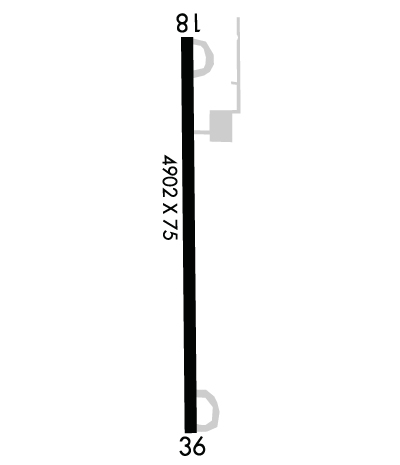
| Lat: N 4136.5 Long: W 07944.5 Elev: 1600 Var: +10 Longest Runway: 4902 | ||
| CTAF: 122.9 | ||
| ||||||||||||||||||||||||||||||||||||||||||||
| ||||||||||||||||||||||||||||||||||||||||||||
| Rwy | Rwy | |||||||
| 4902x75 | 4902' | 4902x75 | 4902' | |||||
| Runway ID | Single Wheel | Double Wheel | Double Tandem Wheel | Dual Double Wheel |
| 01/19 | 12,500 | N/A | N/A | N/A |
| These numbers are Advisory and are not limits. The Airport Manager should have more accurate Weight Limits | ||||
 Airport Diagram might not be current. | |
| Facility Name: | TITUSVILLE |
| City Name: | TITUSVILLE |
| County: | VENANGO |
| State abbrev: | PA |
| State Name: | PENNSYLVANIA |
| Ownership: | PUBLICLY OWNED |
| Use: | OPEN TO THE PUBLIC |
| Owner's Name: | CITY OF TITUSVILLE |
| Address: | 107 NORTH FRANKLIN STREET |
| TITUSVILLE, PA 16354 | |
| Owner's Phone: | (814) 827-5300; EXTN 705 |
| Manager's Name: | NEIL FRATUS |
| Address: | CITY OF TITUSVILLE, 107 NORTH FRANKLIN STREET |
| TITUSVILLE, PA 16354 | |
| Phone: | 814-827-5300; EXTN 705 |
| FAA Region: | EASTERN |
| FAA Field Office: | HAR |
| Date | Sunrise | Sunset |
|---|---|---|
| 04/24/24 Wednesday | 6:24 | 20:10 |
| 04/25/24 Thursday | 6:23 | 20:11 |
| 04/26/24 Friday | 6:22 | 20:12 |
| 04/27/24 Saturday | 6:20 | 20:13 |
| 04/28/24 Sunday | 6:19 | 20:15 |
| 04/29/24 Monday | 6:17 | 20:16 |
| 04/30/24 Tuesday | 6:16 | 20:17 |
| 05/01/24 Wednesday | 6:15 | 20:18 |
| 05/02/24 Thursday | 6:13 | 20:19 |
| 05/03/24 Friday | 6:12 | 20:20 |
| 05/04/24 Saturday | 6:11 | 20:21 |
| 05/05/24 Sunday | 6:10 | 20:22 |
| 05/06/24 Monday | 6:09 | 20:23 |
| 05/07/24 Tuesday | 6:07 | 20:24 |
| Airport Attendance Schedule | UNATTENDED |
| Airport Status | OPERATIONAL (This Status can change at any time - please check NOTAMS) |
| Airport Lighting Schedule | ACTVT MIRL RWY 01/19 ON CTAF. |
| Airport Storage Available | Hanger |
| Extra Services Available | Flight Instruction |
| Wind Indicator | YES - (lighted) |
| Control Tower | NO |
| CTAF Frequency | 122.900 |
| Unicom Frequency | |
| Rotating Beacon Color | WG |
| Segmented Circle | NO |
| Landing Fee | NO |
| Airport Inspected | STATE - performed by STATE AERONAUTICAL PERSONNEL |
| Inspection Date | 01/31/2024 |
| Type of Fuel Available | Grade 100LL, JET A (freeze point -40C) |
| Airframe Repair Service | MINOR |
| Power Plant Repair Service | MINOR |
| Latitude | N4136.5 |
| Longitude | W07944.5 (ESTIMATED) |
| Arpt Elevation | 1599ft (SURVEYED) |
| Magnetic Variation | 10W |
| 3 miles W | of TITUSVILLE |
| Traffic Pattern Altitude | |
| Sectional Chart | DETROIT |
| Operations (Reported) | Yearly | Avg. Daily |
|---|---|---|
| General Aviation Transient | 2250 | 6 |
| General Aviation Local | 6750 | 18 |
| Air Taxi | 0 | 0 |
| Commerical | 0 | 0 |
| Commuter | 0 | 0 |
| Military | 6 | 0 |
| Aircraft based on Field | |
|---|---|
| General Aviation Singles | 9 |
| General Aviation Multi | 1 |
| Jet Aircraft | 0 |
| General Aviation Helicopters | 0 |
| Military Aircraft | 0 |
| Gliders | 0 |
| Ultralights | 0 |
| FSS on field | NO |
| FSS tie-in | ALTOONA |
| FSS Phone | 1-800-WX-BRIEF |
| Who issues Notams | AOO |
| Notam D service at airport | YES |
| ARTCC Name | CLEVELAND |
| Airport Certification | |
| Aircraft Rescue & Firefighting Index | None |
| Airport of Entry | No |
| Custom Landing Rights | No |
| Joint Civil/Military | No |
| Military Landing rights | YES |
| NATIONAL PLAN OF INTEGRATED AIRPORT SYSTEMS (NPIAS) |
| GRANT AGREEMENTS UNDER FAAP/ADAP/AIP |
| ASSURANCES PURSUANT TO TITLE VI, CIVIL RIGHTS ACT OF 1964 |
| BIRDS & DEER ON & INVOF ARPT. |
| RADIO CONTROLLED ACFT INVOF ARPT. |
| GYRO OPNS INVOF ARPT LAST SAT EVERY MONTH. |
| PARALLEL TWY AND NORTH JUG HANDLE TWY MKD WITH BLUE REFLECTORS. |
| FOR CD CTC CLEVELAND ARTCC AT 440-774-0232. |
| FUEL AVBL 24/7 WITH CREDIT CARD |
Airport Communications & Frequencies:
| |||||||||||||||
| Runway: 01 | Runway: 19 | ||
| Mag heading: | 7° | Mag heading: | 187° |
| Rwy Slope: | 1.36% Up | Rwy Slope: | -1.36% Down |
| Approach: | Approach: | ||
| Pattern: | Left Traffic | Pattern: | Left Traffic |
| Markings: | NONPRECISION INSTRUMENT | Markings: | NONPRECISION INSTRUMENT |
| Marking Condition: | GOOD | Marking Condition: | GOOD |
| Arresting Dev: | Arresting Dev: | ||
| Lat & Long: | N4136.1 W07944.5 | Lat. & Long.: | N4136.9 W07944.5 |
| Elev: | 1533.2 ft. MSL | Elev: | 1599.9 ft. MSL |
| TCH: | TCH: | ||
| Visual Glide Path: | Visual Glide Path: | ||
| Displaced Threshold: | No | Displaced Threshold: | No |
| Touchdown Zone: | YES | Touchdown Zone: | YES |
| Touchdown Elev.: | 1570.5 feet | Touchdown Elev.: | 1599.9 feet |
| Visual Glide Slope: | Visual Glide Slope: | ||
| RVR Equipment: | RVR Equipment: | ||
| RVV Equipment: | NO | RVV Equipment: | NO |
| Approach Lights: | Approach Lights: | ||
| REIL: | NO | REIL: | NO |
| Centerline Lights: | NO | Centerline Lights: | NO |
| Touchdown lights: | NO | Touchdown lights: | NO |
| Runway Category: | Runway with a Non-precision Approach | Runway Category: | Runway with a Non-precision Approach |
| Declared Distances: | Declared Distances: | ||
| Obstructions: | TREES | Obstructions: | TREE |
| Marked: | NOT Marked/Lighted | Marked: | NOT Marked/Lighted |
| Clearance slope: | 5:1 | Clearance slope: | 18:1 |
| Obstruction height: | 66 feet AGL | Obstruction height: | 42 feet AGL |
| Dist. from runway: | 551 feet | Dist. from runway: | 989 feet |
| Centerline offset: | 253 left of centerline | Centerline offset: | 282 feet left of centerline |
| Comments: | 14 FT TREES 177 FT FM THLD 219 FT LEFT. | Comments: |
Thanks for using FltPlan.com
all rights reserved © 1999-2024 by Flight Plan LLC
