
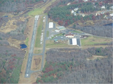
| MINUTE MAN AIR FIELD STOW MA |
| |
| Lat: N 4227.6 Long: W 07131.1 Elev: 280 Var: +16 Longest Runway: 3110 | ||
| Clr Del: 603-594-5552 CTAF: 122.8 | ||
| ||||||||||||||||||||||||||||||||||||||||||||
| ||||||||||||||||||||||||||||||||||||||||||||
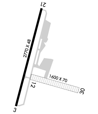
| Rwy | Rwy | |||||||
| 3110x48 | 3110' | 3110x48 | 3110' | |||||
| 1600x40 | 1600' | 1600x40 | 1600' | |||||
| Runway ID | Single Wheel | Double Wheel | Double Tandem Wheel | Dual Double Wheel |
| 03/21 | 12,500 | N/A | N/A | N/A |
| 12/30 | N/A | N/A | N/A | N/A |
| These numbers are Advisory and are not limits. The Airport Manager should have more accurate Weight Limits | ||||
 Airport Diagram might not be current. | |
| Facility Name: | MINUTE MAN AIR FLD |
| City Name: | STOW |
| County: | MIDDLESEX |
| State abbrev: | MA |
| State Name: | MASSACHUSETTS |
| Ownership: | PRIVATELY OWNED |
| Use: | OPEN TO THE PUBLIC |
| Owner's Name: | MINUTE MAN AIRFIELD INC |
| Address: | 302 BOXBORO RD |
| STOW, MA 01775 | |
| Owner's Phone: | 978-897-3933 |
| Manager's Name: | DONALD MC PHERSON |
| Address: | 302 BOXBORO RD |
| STOW, MA 01775 | |
| Phone: | 978-897-3933 |
| FAA Region: | NEW ENGLAND |
| FAA Field Office: | NONE |
| Date | Sunrise | Sunset |
|---|---|---|
| 04/24/24 Wednesday | 5:50 | 19:39 |
| 04/25/24 Thursday | 5:48 | 19:40 |
| 04/26/24 Friday | 5:47 | 19:41 |
| 04/27/24 Saturday | 5:46 | 19:42 |
| 04/28/24 Sunday | 5:44 | 19:43 |
| 04/29/24 Monday | 5:43 | 19:44 |
| 04/30/24 Tuesday | 5:41 | 19:46 |
| 05/01/24 Wednesday | 5:40 | 19:47 |
| 05/02/24 Thursday | 5:39 | 19:48 |
| 05/03/24 Friday | 5:37 | 19:49 |
| 05/04/24 Saturday | 5:36 | 19:50 |
| 05/05/24 Sunday | 5:35 | 19:51 |
| 05/06/24 Monday | 5:34 | 19:52 |
| 05/07/24 Tuesday | 5:32 | 19:53 |
| Airport Attendance Schedule | 7 Days A Week 0900-1600 |
| Airport Status | OPERATIONAL (This Status can change at any time - please check NOTAMS) |
| Airport Lighting Schedule | ACTVT REIL RWY 21 - CTAF. |
| Airport Storage Available | Tie Downs, Hanger |
| Extra Services Available | Flight Instruction, Aircraft Rental, Aircraft Sales |
| Wind Indicator | YES - (unlit) |
| Control Tower | NO |
| CTAF Frequency | 122.800 |
| Unicom Frequency | 122.800 |
| Rotating Beacon Color | WG |
| Segmented Circle | YES |
| Landing Fee | NO |
| Airport Inspected | STATE - performed by STATE AERONAUTICAL PERSONNEL |
| Inspection Date | 05/08/2019 |
| Type of Fuel Available | Grade 100LL |
| Airframe Repair Service | MAJOR |
| Power Plant Repair Service | MAJOR |
| Latitude | N4227.6 |
| Longitude | W07131.1 (ESTIMATED) |
| Arpt Elevation | 280ft (ESTIMATED) |
| Magnetic Variation | 16W |
| 2 miles N | of STOW |
| Traffic Pattern Altitude | 1032 |
| Sectional Chart | NEW YORK |
| Operations (Reported) | Yearly | Avg. Daily |
|---|---|---|
| General Aviation Transient | 13150 | 36 |
| General Aviation Local | 12500 | 34 |
| Air Taxi | 85 | 0 |
| Commerical | 0 | 0 |
| Commuter | 0 | 0 |
| Military | 15 | 0 |
| Aircraft based on Field | |
|---|---|
| General Aviation Singles | 66 |
| General Aviation Multi | 0 |
| Jet Aircraft | 0 |
| General Aviation Helicopters | 0 |
| Military Aircraft | 0 |
| Gliders | 1 |
| Ultralights | 0 |
| FSS on field | NO |
| FSS tie-in | BRIDGEPORT |
| FSS Phone | 1-800-WX-BRIEF |
| Who issues Notams | BDR |
| Notam D service at airport | YES |
| ARTCC Name | BOSTON |
| Airport Certification | |
| Aircraft Rescue & Firefighting Index | None |
| Airport of Entry | No |
| Custom Landing Rights | No |
| Joint Civil/Military | No |
| Military Landing rights | No |
| NATIONAL PLAN OF INTEGRATED AIRPORT SYSTEMS (NPIAS) |
| ASSURANCES PURSUANT TO TITLE VI, CIVIL RIGHTS ACT OF 1964 |
| TPA FOR LGT ACFT 1032 FT AGL. |
| BFR USING RWY 12/30 CALL AMGR TO DTRM RWY CONDS. |
| TREE OBSTN IN APCH; PRIM & TRSN SFCS RWYS 03 & 12/30. |
| NOISE ABATEMENT PROCS IN EFCT NTFY AMGR 978-897-3933 OF INTN TO OPR BTN 2300-0600. |
| FOR CD CTC BOSTON APCH AT 603-594-5552. |
Airport Communications & Frequencies:
| |||||||||||||||||
| Runway: 03 | Runway: 21 | ||
| Mag heading: | 33° | Mag heading: | 213° |
| Rwy Slope: | -.39% Down | Rwy Slope: | .39% Up |
| Approach: | Approach: | ||
| Pattern: | Left Traffic | Pattern: | Left Traffic |
| Markings: | BASIC | Markings: | NONPRECISION INSTRUMENT |
| Marking Condition: | GOOD | Marking Condition: | GOOD |
| Arresting Dev: | Arresting Dev: | ||
| Lat & Long: | N4227.4 W07131.2 | Lat. & Long.: | N4227.9 W07131.0 |
| Elev: | 280.0 ft. MSL | Elev: | 268.0 ft. MSL |
| TCH: | TCH: | 24 ft. AGL | |
| Visual Glide Path: | Visual Glide Path: | 3.50 degrees | |
| Displaced Threshold: | No | Displaced Threshold: | No |
| Touchdown Zone: | YES | Touchdown Zone: | YES |
| Touchdown Elev.: | 280.0 feet | Touchdown Elev.: | 268.0 feet |
| Visual Glide Slope: | Visual Glide Slope: | 2-Light PAPI on LEFT side of Runway | |
| RVR Equipment: | RVR Equipment: | ||
| RVV Equipment: | NO | RVV Equipment: | NO |
| Approach Lights: | Approach Lights: | ||
| REIL: | NO | REIL: | YES |
| Centerline Lights: | NO | Centerline Lights: | NO |
| Touchdown lights: | NO | Touchdown lights: | NO |
| Runway Category: | Runway with a Visual Approach | Runway Category: | Runway with a Non-precision Approach |
| Declared Distances: | Declared Distances: | ||
| Obstructions: | HILL | Obstructions: | TREES |
| Marked: | LIGHTED | Marked: | NOT Marked/Lighted |
| Clearance slope: | 2:1 | Clearance slope: | 23:1 |
| Obstruction height: | 48 feet AGL | Obstruction height: | 70 feet AGL |
| Dist. from runway: | 340 feet | Dist. from runway: | 1850 feet |
| Centerline offset: | 270 left of centerline | Centerline offset: | 125 feet right of centerline |
| Comments: | GND RISES GRADUALLY TO +12 FT FM END OF PAVEMENT. | Comments: |
| Runway: 12 | Runway: 30 | ||
| Mag heading: | 122° | Mag heading: | 302° |
| Rwy Slope: | -.31% Down | Rwy Slope: | .31% Up |
| Approach: | Approach: | ||
| Pattern: | Left Traffic | Pattern: | Left Traffic |
| Markings: | Markings: | ||
| Marking Condition: | Marking Condition: | ||
| Arresting Dev: | Arresting Dev: | ||
| Lat & Long: | N4227.6 W07131.2 | Lat. & Long.: | N4227.5 W07130.8 |
| Elev: | 259.0 ft. MSL | Elev: | 254.0 ft. MSL |
| TCH: | TCH: | ||
| Visual Glide Path: | Visual Glide Path: | ||
| Displaced Threshold: | No | Displaced Threshold: | No |
| Touchdown Zone: | YES | Touchdown Zone: | YES |
| Touchdown Elev.: | 259.0 feet | Touchdown Elev.: | 259.0 feet |
| Visual Glide Slope: | Visual Glide Slope: | ||
| RVR Equipment: | RVR Equipment: | ||
| RVV Equipment: | NO | RVV Equipment: | NO |
| Approach Lights: | Approach Lights: | ||
| REIL: | NO | REIL: | NO |
| Centerline Lights: | NO | Centerline Lights: | NO |
| Touchdown lights: | NO | Touchdown lights: | NO |
| Runway Category: | Runway with a Visual Approach | Runway Category: | Runway with a Visual Approach |
| Declared Distances: | Declared Distances: | ||
| Obstructions: | TREES | Obstructions: | TREES |
| Marked: | NOT Marked/Lighted | Marked: | NOT Marked/Lighted |
| Clearance slope: | 10:1 | Clearance slope: | 8:1 |
| Obstruction height: | 30 feet AGL | Obstruction height: | 50 feet AGL |
| Dist. from runway: | 300 feet | Dist. from runway: | 400 feet |
| Centerline offset: | 125 | Centerline offset: | 125 feet left of centerline |
| Comments: | Comments: |
Thanks for using FltPlan.com
all rights reserved © 1999-2024 by Flight Plan LLC