
| BUTLER MUNI BUTLER GA |
| |
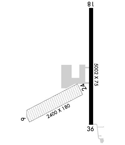
| Lat: N 3234.1 Long: W 08414.8 Elev: 667 Var: +05 Longest Runway: 5002 | ||
| AWOS: 119.52 CTAF: 122.9 | ||
| ||||||||||||||||||||||||||||||||
| ||||||||||||||||||||||||||||||||
| ||||||||||||||||||||||||||||||||
| Rwy | Rwy | |||||||
| 5002x75 | 5002' | 5002x75 | 5002' | |||||
| 2405x180 | 2405' | 2405x180 | 2405' | |||||
| Runway ID | Single Wheel | Double Wheel | Double Tandem Wheel | Dual Double Wheel |
| 01/19 | 17,000 | N/A | N/A | N/A |
| 06/24 | N/A | N/A | N/A | N/A |
| These numbers are Advisory and are not limits. The Airport Manager should have more accurate Weight Limits | ||||
 Airport Diagram might not be current. | |
| Facility Name: | BUTLER MUNI |
| City Name: | BUTLER |
| County: | TAYLOR |
| State abbrev: | GA |
| State Name: | GEORGIA |
| Ownership: | PUBLICLY OWNED |
| Use: | OPEN TO THE PUBLIC |
| Owner's Name: | TAYLOR COUNTY |
| Address: | BOX 278 |
| BUTLER, GA 31006 | |
| Owner's Phone: | 478-862-3336 |
| Manager's Name: | CODY RUSTIN |
| Address: | BOX 553 |
| BUTLER, GA 31006 | |
| Phone: | 478-837-5490 |
| FAA Region: | SOUTHERN |
| FAA Field Office: | ATL |
| Date | Sunrise | Sunset |
|---|---|---|
| 04/25/24 Thursday | 6:55 | 20:15 |
| 04/26/24 Friday | 6:54 | 20:15 |
| 04/27/24 Saturday | 6:53 | 20:16 |
| 04/28/24 Sunday | 6:52 | 20:17 |
| 04/29/24 Monday | 6:51 | 20:18 |
| 04/30/24 Tuesday | 6:50 | 20:18 |
| 05/01/24 Wednesday | 6:49 | 20:19 |
| 05/02/24 Thursday | 6:48 | 20:20 |
| 05/03/24 Friday | 6:48 | 20:20 |
| 05/04/24 Saturday | 6:47 | 20:21 |
| 05/05/24 Sunday | 6:46 | 20:22 |
| 05/06/24 Monday | 6:45 | 20:23 |
| 05/07/24 Tuesday | 6:44 | 20:23 |
| 05/08/24 Wednesday | 6:43 | 20:24 |
| Airport Attendance Schedule | UNATTENDED |
| Airport Status | OPERATIONAL (This Status can change at any time - please check NOTAMS) |
| Airport Lighting Schedule | DUSK-2300. MIRL RY 01/19 OPER DUSK-2400; AFT 2400 ACTVT - CTAF. |
| Airport Storage Available | Tie Downs |
| Extra Services Available | Glider |
| Wind Indicator | YES - (lighted) |
| Control Tower | NO |
| CTAF Frequency | 122.900 |
| Unicom Frequency | |
| Rotating Beacon Color | WG |
| Segmented Circle | YES |
| Landing Fee | NO |
| Airport Inspected | STATE - performed by STATE AERONAUTICAL PERSONNEL |
| Inspection Date | 02/01/2024 |
| Type of Fuel Available | Grade 100LL |
| Airframe Repair Service | MAJOR |
| Power Plant Repair Service | MAJOR |
| Latitude | N3234.1 |
| Longitude | W08414.8 (ESTIMATED) |
| Arpt Elevation | 667ft (ESTIMATED) |
| Magnetic Variation | 05W |
| 1 miles NW | of BUTLER |
| Traffic Pattern Altitude | |
| Sectional Chart | ATLANTA |
| Operations (Reported) | Yearly | Avg. Daily |
|---|---|---|
| General Aviation Transient | 2000 | 5 |
| General Aviation Local | 5500 | 15 |
| Air Taxi | 0 | 0 |
| Commerical | 0 | 0 |
| Commuter | 0 | 0 |
| Military | 0 | 0 |
| Aircraft based on Field | |
|---|---|
| General Aviation Singles | 15 |
| General Aviation Multi | 0 |
| Jet Aircraft | 0 |
| General Aviation Helicopters | 0 |
| Military Aircraft | 0 |
| Gliders | 0 |
| Ultralights | 0 |
| FSS on field | NO |
| FSS tie-in | MACON |
| FSS Phone | 1-800-WX-BRIEF |
| Who issues Notams | MCN |
| Notam D service at airport | YES |
| ARTCC Name | ATLANTA |
| Airport Certification | |
| Aircraft Rescue & Firefighting Index | None |
| Airport of Entry | No |
| Custom Landing Rights | No |
| Joint Civil/Military | No |
| Military Landing rights | YES |
| NATIONAL PLAN OF INTEGRATED AIRPORT SYSTEMS (NPIAS) |
| ASSURANCES PURSUANT TO TITLE VI, CIVIL RIGHTS ACT OF 1964 |
| GRANT AGREEMENT HAS EXPIRED; HOWEVER, AGREEMENT REMAINS IN EFFECT FOR THIS FACILITY AS LONG AS IT IS PUBLIC USE. |
| FOR CD CTC ATLANTA APCH AT 678-364-6132, WHEN APCH CLSD CTC ATLANTA ARTCC AT 770-210-7692. |
Airport Communications & Frequencies:
| |||||||||||||||||||
| Runway: 01 | Runway: 19 | ||
| Mag heading: | 5° | Mag heading: | 185° |
| Rwy Slope: | -.77% Down | Rwy Slope: | .77% Up |
| Approach: | Approach: | ||
| Pattern: | Left Traffic | Pattern: | Left Traffic |
| Markings: | NONPRECISION INSTRUMENT | Markings: | NONPRECISION INSTRUMENT |
| Marking Condition: | GOOD | Marking Condition: | GOOD |
| Arresting Dev: | Arresting Dev: | ||
| Lat & Long: | N3233.8 W08414.7 | Lat. & Long.: | N3234.6 W08414.7 |
| Elev: | 659.2 ft. MSL | Elev: | 620.6 ft. MSL |
| TCH: | 30 ft. AGL | TCH: | 33 ft. AGL |
| Visual Glide Path: | 2.75 degrees | Visual Glide Path: | 3.00 degrees |
| Displaced Threshold: | No | Displaced Threshold: | No |
| Touchdown Zone: | YES | Touchdown Zone: | YES |
| Touchdown Elev.: | 659.2 feet | Touchdown Elev.: | 646.7 feet |
| Visual Glide Slope: | 2-Light PAPI on LEFT side of Runway | Visual Glide Slope: | 2-Light PAPI on LEFT side of Runway |
| RVR Equipment: | RVR Equipment: | ||
| RVV Equipment: | NO | RVV Equipment: | NO |
| Approach Lights: | Approach Lights: | ||
| REIL: | NO | REIL: | NO |
| Centerline Lights: | NO | Centerline Lights: | NO |
| Touchdown lights: | NO | Touchdown lights: | NO |
| Runway Category: | Runway with a Non-precision Approach having visibility minimums greater than 3/4 mile | Runway Category: | Runway with a Non-precision Approach having visibility minimums greater than 3/4 mile |
| Declared Distances: | Declared Distances: | ||
| Obstructions: | TREES | Obstructions: | |
| Marked: | NOT Marked/Lighted | Marked: | |
| Clearance slope: | 20:1 | Clearance slope: | 50:1 |
| Obstruction height: | 39 feet AGL | Obstruction height: | |
| Dist. from runway: | 980 feet | Dist. from runway: | |
| Centerline offset: | 150 right of centerline | Centerline offset: | |
| Comments: | Comments: |
| Runway: 06 | Runway: 24 | ||
| Mag heading: | 68° | Mag heading: | 248° |
| Rwy Slope: | -.29% Down | Rwy Slope: | .29% Up |
| Approach: | Approach: | ||
| Pattern: | Left Traffic | Pattern: | Left Traffic |
| Markings: | NONSTANDARD | Markings: | NONSTANDARD |
| Marking Condition: | FAIR; RY 6/24 ENDS AND EDGES MARKED WITH INGROUND CONCRETE PADS. | Marking Condition: | FAIR |
| Arresting Dev: | Arresting Dev: | ||
| Lat & Long: | N3233.8 W08415.2 | Lat. & Long.: | N3234.0 W08414.8 |
| Elev: | 662.0 ft. MSL | Elev: | 655.0 ft. MSL |
| TCH: | TCH: | ||
| Visual Glide Path: | Visual Glide Path: | ||
| Displaced Threshold: | No | Displaced Threshold: | No |
| Touchdown Zone: | YES | Touchdown Zone: | YES |
| Touchdown Elev.: | 662.0 feet | Touchdown Elev.: | 662.0 feet |
| Visual Glide Slope: | Visual Glide Slope: | ||
| RVR Equipment: | RVR Equipment: | ||
| RVV Equipment: | NO | RVV Equipment: | NO |
| Approach Lights: | Approach Lights: | ||
| REIL: | NO | REIL: | NO |
| Centerline Lights: | NO | Centerline Lights: | NO |
| Touchdown lights: | NO | Touchdown lights: | NO |
| Runway Category: | Runway with a Visual Approach | Runway Category: | Runway with a Visual Approach |
| Declared Distances: | Declared Distances: | ||
| Obstructions: | TREES | Obstructions: | TREES |
| Marked: | NOT Marked/Lighted | Marked: | NOT Marked/Lighted |
| Clearance slope: | 6:1; RY 06 APCH RATIO 20:1 TO DSPLCD THLD, 54' TREE, 1280' FROM DISP THRESHOLD, 160' RIGHT. | Clearance slope: | 13:1 |
| Obstruction height: | 36 feet AGL | Obstruction height: | 56 feet AGL |
| Dist. from runway: | 216 feet | Dist. from runway: | 728 feet |
| Centerline offset: | 130 right of centerline | Centerline offset: | 146 feet left of centerline |
| Comments: | Comments: |
Thanks for using FltPlan.com
all rights reserved © 1999-2024 by Flight Plan LLC