
| TWIN CITY LORIS SC |
| |
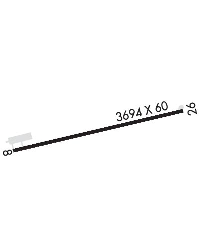
| Lat: N 3405.3 Long: W 07851.9 Elev: 99 Var: +08 Longest Runway: 3694 | ||
| CTAF: 122.9 | ||
| ||||||||||||||||||||||||||||||||
| ||||||||||||||||||||||||||||||||
| Rwy | Rwy | |||||||
| 3694x60 | 3494' | 3694x60 | 3694' | |||||
| Runway ID | Single Wheel | Double Wheel | Double Tandem Wheel | Dual Double Wheel |
| 08/26 | 8,000 | N/A | N/A | N/A |
| These numbers are Advisory and are not limits. The Airport Manager should have more accurate Weight Limits | ||||
 Airport Diagram might not be current. | |
| Facility Name: | TWIN CITY |
| City Name: | LORIS |
| County: | HORRY |
| State abbrev: | SC |
| State Name: | SOUTH CAROLINA |
| Ownership: | PUBLICLY OWNED |
| Use: | OPEN TO THE PUBLIC |
| Owner's Name: | HORRY COUNTY |
| Address: | PO BOX 1236 |
| CONWAY, SC 29526 | |
| Owner's Phone: | 843-448-1580 |
| Manager's Name: | JUDI OLMSTEAD |
| Address: | 1100 JETPORT RD |
| MYRTLE BEACH, SC 29577 | |
| Phone: | 843-839-7359 |
| FAA Region: | SOUTHERN |
| FAA Field Office: | ATL |
| Date | Sunrise | Sunset |
|---|---|---|
| 04/25/24 Thursday | 6:32 | 19:55 |
| 04/26/24 Friday | 6:31 | 19:56 |
| 04/27/24 Saturday | 6:30 | 19:57 |
| 04/28/24 Sunday | 6:29 | 19:58 |
| 04/29/24 Monday | 6:27 | 19:58 |
| 04/30/24 Tuesday | 6:26 | 19:59 |
| 05/01/24 Wednesday | 6:25 | 20:00 |
| 05/02/24 Thursday | 6:24 | 20:01 |
| 05/03/24 Friday | 6:23 | 20:02 |
| 05/04/24 Saturday | 6:22 | 20:02 |
| 05/05/24 Sunday | 6:22 | 20:03 |
| 05/06/24 Monday | 6:21 | 20:04 |
| 05/07/24 Tuesday | 6:20 | 20:05 |
| 05/08/24 Wednesday | 6:19 | 20:05 |
| Airport Attendance Schedule | UNATTENDED |
| Airport Status | OPERATIONAL (This Status can change at any time - please check NOTAMS) |
| Airport Lighting Schedule | |
| Airport Storage Available | Tie Downs |
| Extra Services Available | NONE |
| Wind Indicator | YES - (lighted) |
| Control Tower | NO |
| CTAF Frequency | 122.900 |
| Unicom Frequency | |
| Rotating Beacon Color | WG |
| Segmented Circle | YES |
| Landing Fee | NO |
| Airport Inspected | STATE - performed by STATE AERONAUTICAL PERSONNEL |
| Inspection Date | 09/12/2023 |
| Type of Fuel Available | None |
| Airframe Repair Service | NONE |
| Power Plant Repair Service | NONE |
| Latitude | N3405.3 |
| Longitude | W07851.9 (ESTIMATED) |
| Arpt Elevation | 99ft (SURVEYED) |
| Magnetic Variation | 08W |
| 3 miles NE | of LORIS |
| Traffic Pattern Altitude | |
| Sectional Chart | CHARLOTTE |
| Operations (Reported) | Yearly | Avg. Daily |
|---|---|---|
| General Aviation Transient | 600 | 2 |
| General Aviation Local | 600 | 2 |
| Air Taxi | 0 | 0 |
| Commerical | 0 | 0 |
| Commuter | 0 | 0 |
| Military | 0 | 0 |
| Aircraft based on Field | |
|---|---|
| General Aviation Singles | 2 |
| General Aviation Multi | 2 |
| Jet Aircraft | 0 |
| General Aviation Helicopters | 0 |
| Military Aircraft | 0 |
| Gliders | 0 |
| Ultralights | 0 |
| FSS on field | NO |
| FSS tie-in | ANDERSON |
| FSS Phone | 1-800-WX-BRIEF |
| Who issues Notams | AND |
| Notam D service at airport | YES |
| ARTCC Name | JACKSONVILLE |
| Airport Certification | |
| Aircraft Rescue & Firefighting Index | None |
| Airport of Entry | No |
| Custom Landing Rights | No |
| Joint Civil/Military | No |
| Military Landing rights | No |
| NATIONAL PLAN OF INTEGRATED AIRPORT SYSTEMS (NPIAS) |
| THIS AIRPORT HAS BEEN SURVEYED BY THE NATIONAL GEODETIC SURVEY. |
| 30 FT POWER LINE 180 FT SOUTH OF RWY 8-26. |
| BIRDS ON AND INVOF ARPT. |
| FOR CD CTC MYRTLE BEACH APCH AT 843-477-2727 OR 843-477-2704, WHEN APCH CLSD CTC JACKSONVILLE ARTCC AT 904-845-1592. |
Airport Communications & Frequencies:
| |||||||||||||||
| Runway: 08 | Runway: 26 | ||
| Mag heading: | 82° | Mag heading: | 262° |
| Rwy Slope: | .00% Up | Rwy Slope: | .00% Down |
| Approach: | Approach: | ||
| Pattern: | Left Traffic | Pattern: | Left Traffic |
| Markings: | BASIC | Markings: | BASIC |
| Marking Condition: | GOOD | Marking Condition: | GOOD |
| Arresting Dev: | Arresting Dev: | ||
| Lat & Long: | N3405.2 W07852.2 | Lat. & Long.: | N3405.4 W07851.5 |
| Elev: | 99.2 ft. MSL | Elev: | 99.3 ft. MSL |
| TCH: | TCH: | 38 ft. AGL | |
| Visual Glide Path: | Visual Glide Path: | 3.50 degrees | |
| Displaced Threshold: | 200 feet | Displaced Threshold: | No |
| Touchdown Zone: | YES | Touchdown Zone: | YES |
| Touchdown Elev.: | 99.3 feet | Touchdown Elev.: | 99.3 feet |
| Visual Glide Slope: | Visual Glide Slope: | 2-BOX SIMPLIFIED ABBREVIATED VISUAL APPROACH SLOPE INDICATOR ON LEFT SIDE OF RUNWAY | |
| RVR Equipment: | RVR Equipment: | ||
| RVV Equipment: | NO | RVV Equipment: | NO |
| Approach Lights: | Approach Lights: | ||
| REIL: | NO | REIL: | NO |
| Centerline Lights: | NO | Centerline Lights: | NO |
| Touchdown lights: | NO | Touchdown lights: | NO |
| Runway Category: | Runway with a Visual Approach | Runway Category: | Runway with a Non-precision Approach |
| Declared Distances: | Declared Distances: | ||
| Obstructions: | ROAD | Obstructions: | TREES |
| Marked: | NOT Marked/Lighted | Marked: | NOT Marked/Lighted |
| Clearance slope: | 1:1; RWY 08 ST-IN APPR 21:1 TO DSP THR DUE TO 17' ROADWAY BOTH SIDES OF CENTERLINE; 358' FROM DSP THR. 50FT TREES 175' R AND AIRCRAFT ACTIVITY APRON 150' L LOCATED PARALLEL TO RWY. | Clearance slope: | 18:1 |
| Obstruction height: | 17 feet AGL | Obstruction height: | 86 feet AGL |
| Dist. from runway: | 200 feet | Dist. from runway: | 1759 feet |
| Centerline offset: | Centerline offset: | 10 feet right of centerline | |
| Comments: | RWY 08 ROADWAY AND 50FT TREES 150' TO 175' R;DIST 0 TO 200 FT FROM RWY. AIRCRAFT ACTIVITY APRON 150FT R, DIST 0 TO 125' FROM RWY. | Comments: |
Thanks for using FltPlan.com
all rights reserved © 1999-2024 by Flight Plan LLC
