
| ARCADIA-BIENVILLE PARISH ARCADIA LA |
| |
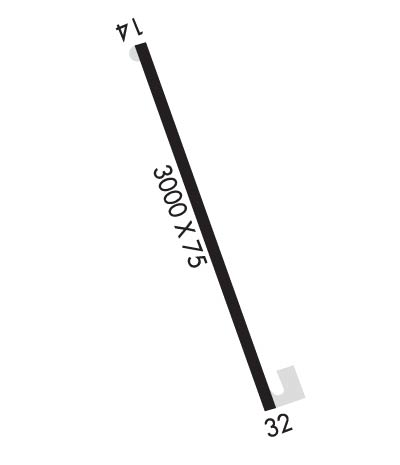
| Lat: N 3231.9 Long: W 09257.2 Elev: 440 Var: -04 Longest Runway: 3000 | ||
| CTAF: 122.9 | ||
| ||||||||||||||||||||||||||||||||
| ||||||||||||||||||||||||||||||||
| Rwy | Rwy | |||||||
| 3000x75 | 3000' | 3000x75 | 3000' | |||||
| Runway ID | Single Wheel | Double Wheel | Double Tandem Wheel | Dual Double Wheel |
| 14/32 | 16,000 | N/A | N/A | N/A |
| These numbers are Advisory and are not limits. The Airport Manager should have more accurate Weight Limits | ||||
| FltPlan does not have IFR approach charts available for K5F0. |
 Airport Diagram might not be current. | |
| Facility Name: | ARCADIA-BIENVILLE PARISH |
| City Name: | ARCADIA |
| County: | BIENVILLE |
| State abbrev: | LA |
| State Name: | LOUISIANA |
| Ownership: | PUBLICLY OWNED |
| Use: | OPEN TO THE PUBLIC |
| Owner's Name: | MAYOR, CITY OF ARCADIA |
| Address: | PO BOX 767 |
| ARCADIA, LA 71001 | |
| Owner's Phone: | 318-263-8456 |
| Manager's Name: | ANTOINE HAMPTON |
| Address: | PO BOX 767 |
| ARCADIA, LA 71001 | |
| Phone: | 318-263-8456 |
| FAA Region: | SOUTHWEST |
| FAA Field Office: | LNM |
| Date | Sunrise | Sunset |
|---|---|---|
| 05/06/24 Monday | 6:20 | 19:57 |
| 05/07/24 Tuesday | 6:19 | 19:58 |
| 05/08/24 Wednesday | 6:18 | 19:59 |
| 05/09/24 Thursday | 6:17 | 20:00 |
| 05/10/24 Friday | 6:16 | 20:00 |
| 05/11/24 Saturday | 6:16 | 20:01 |
| 05/12/24 Sunday | 6:15 | 20:02 |
| 05/13/24 Monday | 6:14 | 20:02 |
| 05/14/24 Tuesday | 6:14 | 20:03 |
| 05/15/24 Wednesday | 6:13 | 20:04 |
| 05/16/24 Thursday | 6:12 | 20:05 |
| 05/17/24 Friday | 6:12 | 20:05 |
| 05/18/24 Saturday | 6:11 | 20:06 |
| 05/19/24 Sunday | 6:10 | 20:07 |
| Airport Attendance Schedule | UNATTENDED; FOR ARPT ATTENDANT CALL 318-263-2013. |
| Airport Status | OPERATIONAL (This Status can change at any time - please check NOTAMS) |
| Airport Lighting Schedule | ACTVT MIRL RWY 14/32 - CTAF. |
| Airport Storage Available | NONE |
| Extra Services Available | NONE |
| Wind Indicator | YES - (unlit) |
| Control Tower | NO |
| CTAF Frequency | 122.900 |
| Unicom Frequency | |
| Rotating Beacon Color | WG; ROTG BCN 0.5 MILE SE OF ARPT. |
| Segmented Circle | NO |
| Landing Fee | NO |
| Airport Inspected | STATE - performed by STATE AERONAUTICAL PERSONNEL |
| Inspection Date | 10/24/2023 |
| Type of Fuel Available | None |
| Airframe Repair Service | NONE |
| Power Plant Repair Service | NONE |
| Latitude | N3231.9 |
| Longitude | W09257.2 (ESTIMATED) |
| Arpt Elevation | 440ft (ESTIMATED) |
| Magnetic Variation | 04E |
| 2 miles SW | of ARCADIA |
| Traffic Pattern Altitude | |
| Sectional Chart | MEMPHIS |
| Operations (Reported) | Yearly | Avg. Daily |
|---|---|---|
| General Aviation Transient | 3200 | 9 |
| General Aviation Local | 5200 | 14 |
| Air Taxi | 0 | 0 |
| Commerical | 0 | 0 |
| Commuter | 0 | 0 |
| Military | 0 | 0 |
| Aircraft based on Field | |
|---|---|
| General Aviation Singles | 5 |
| General Aviation Multi | 0 |
| Jet Aircraft | 0 |
| General Aviation Helicopters | 0 |
| Military Aircraft | 0 |
| Gliders | 0 |
| Ultralights | 0 |
| FSS on field | NO |
| FSS tie-in | DE RIDDER |
| FSS Phone | 1-800-WX-BRIEF |
| Who issues Notams | DRI |
| Notam D service at airport | YES |
| ARTCC Name | FORT WORTH |
| Airport Certification | |
| Aircraft Rescue & Firefighting Index | None |
| Airport of Entry | No |
| Custom Landing Rights | No |
| Joint Civil/Military | No |
| Military Landing rights | No |
| GOLF CRS ADJ TO ARPT. |
| HOLD SHRT LINE NSTD DIST FM RWY. |
| FOR CD CTC FORT WORTH ARTCC AT 817-858-7584. |
| ROTG BCN 0.5 MILE SE OF ARPT OTS |
| RWY 14/3 2 MIRLS RWY 14/32 OTS INDEFLY. |
| Runway: 14 | Runway: 32 | ||
| Mag heading: | 145° | Mag heading: | 325° |
| Rwy Slope: | -.07% Down | Rwy Slope: | .07% Up |
| Approach: | Approach: | ||
| Pattern: | Left Traffic | Pattern: | Left Traffic |
| Markings: | NONPRECISION INSTRUMENT | Markings: | NONPRECISION INSTRUMENT |
| Marking Condition: | FAIR | Marking Condition: | FAIR |
| Arresting Dev: | Arresting Dev: | ||
| Lat & Long: | N3232.1 W09257.3 | Lat. & Long.: | N3231.7 W09257.0 |
| Elev: | 438.0 ft. MSL | Elev: | 436.0 ft. MSL |
| TCH: | TCH: | ||
| Visual Glide Path: | Visual Glide Path: | ||
| Displaced Threshold: | No | Displaced Threshold: | No |
| Touchdown Zone: | NO | Touchdown Zone: | NO |
| Touchdown Elev.: | Touchdown Elev.: | ||
| Visual Glide Slope: | Visual Glide Slope: | ||
| RVR Equipment: | RVR Equipment: | ||
| RVV Equipment: | NO | RVV Equipment: | NO |
| Approach Lights: | Approach Lights: | ||
| REIL: | NO | REIL: | NO |
| Centerline Lights: | NO | Centerline Lights: | NO |
| Touchdown lights: | NO | Touchdown lights: | NO |
| Runway Category: | Runway with a Visual Approach | Runway Category: | Runway with a Visual Approach |
| Declared Distances: | Declared Distances: | ||
| Obstructions: | TREES | Obstructions: | TREES |
| Marked: | NOT Marked/Lighted | Marked: | NOT Marked/Lighted |
| Clearance slope: | 21:1 | Clearance slope: | 11:1 |
| Obstruction height: | 76 feet AGL | Obstruction height: | 47 feet AGL |
| Dist. from runway: | 1836 feet | Dist. from runway: | 769 feet |
| Centerline offset: | 318 right of centerline | Centerline offset: | |
| Comments: | 30 FT TREES 221 FT FM END OF RWY 103 FT RIGHT OF CNTRLN. | Comments: | GOLF CART PATH ROAD 193 FT FROM END OF RWY. |
Thanks for using FltPlan.com
all rights reserved © 1999-2024 by Flight Plan LLC
