| SARATOGA COUNTY SARATOGA SPRINGS NY |
| |
| Lat: N 4303.0 Long: W 07351.7 Elev: 434 Var: +14 Longest Runway: 4699 | ||
| AWOS: 132.02 CTAF: 123.07 | ||
| ||||||
| ||||||
|
| FBOs at nearby airports who want your business: | |||||||||||
| |||||||||||
| Rwy | Rwy | |||||||
| 4699x100 | 4699' | 4699x100 | 4699' | |||||
| 4000x100 | 4000' | 4000x100 | 4000' | |||||
| Runway ID | Single Wheel | Double Wheel | Double Tandem Wheel | Dual Double Wheel |
| 05/23 | 116,000 | 192,000 | N/A | N/A |
| 14/32 | 83,000 | 126,000 | N/A | N/A |
| These numbers are Advisory and are not limits. The Airport Manager should have more accurate Weight Limits | ||||
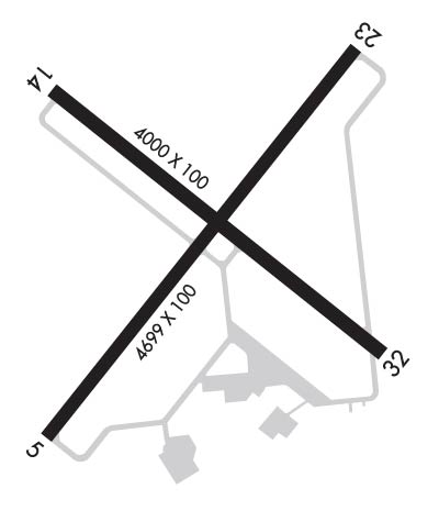 Airport Diagram might not be current. | |
| Facility Name: | SARATOGA COUNTY |
| City Name: | SARATOGA SPRINGS |
| County: | SARATOGA |
| State abbrev: | NY |
| State Name: | NEW YORK |
| Ownership: | PUBLICLY OWNED |
| Use: | OPEN TO THE PUBLIC |
| Owner's Name: | SARATOGA COUNTY |
| Address: | 3654 GALWAY RD |
| BALLSTON SPA, NY 12020 | |
| Owner's Phone: | 518-885-2235; GREG BALL, SARATOGA CO DPW. |
| Manager's Name: | JON ZILKA; FBO |
| Address: | 405 GREENFIELD AVE. |
| BALLSTON SPA, NY 12020 | |
| Phone: | 518-885-5470 |
| FAA Region: | EASTERN |
| FAA Field Office: | NYC |
| Date | Sunrise | Sunset |
|---|---|---|
| 04/24/24 Wednesday | 5:58 | 19:49 |
| 04/25/24 Thursday | 5:57 | 19:51 |
| 04/26/24 Friday | 5:55 | 19:52 |
| 04/27/24 Saturday | 5:54 | 19:53 |
| 04/28/24 Sunday | 5:52 | 19:54 |
| 04/29/24 Monday | 5:51 | 19:55 |
| 04/30/24 Tuesday | 5:50 | 19:56 |
| 05/01/24 Wednesday | 5:48 | 19:57 |
| 05/02/24 Thursday | 5:47 | 19:59 |
| 05/03/24 Friday | 5:45 | 20:00 |
| 05/04/24 Saturday | 5:44 | 20:01 |
| 05/05/24 Sunday | 5:43 | 20:02 |
| 05/06/24 Monday | 5:42 | 20:03 |
| 05/07/24 Tuesday | 5:40 | 20:04 |
| Airport Attendance Schedule | 7 Days A Week 0730-DUSK |
| Airport Status | OPERATIONAL (This Status can change at any time - please check NOTAMS) |
| Airport Lighting Schedule | ACTVT REIL RWY 05/23; MIRL RWY 05/23 - CTAF. |
| Airport Storage Available | Tie Downs, Hanger |
| Extra Services Available | Avionics, Charter, Flight Instruction, Aircraft Sales |
| Wind Indicator | YES - (unlit) |
| Control Tower | NO |
| CTAF Frequency | 123.075 |
| Unicom Frequency | 123.075 |
| Rotating Beacon Color | WG |
| Segmented Circle | NO |
| Landing Fee | NO |
| Airport Inspected | STATE - performed by STATE AERONAUTICAL PERSONNEL |
| Inspection Date | 07/11/2023 |
| Type of Fuel Available | Grade 100LL, JET A (freeze point -40C) |
| Airframe Repair Service | MAJOR |
| Power Plant Repair Service | MAJOR |
| Latitude | N4303.0 |
| Longitude | W07351.7 (ESTIMATED) |
| Arpt Elevation | 433ft (SURVEYED) |
| Magnetic Variation | 14W |
| 3 miles SW | of SARATOGA SPRINGS |
| Traffic Pattern Altitude | 767 |
| Sectional Chart | NEW YORK |
| Operations (Reported) | Yearly | Avg. Daily |
|---|---|---|
| General Aviation Transient | 15000 | 41 |
| General Aviation Local | 22000 | 60 |
| Air Taxi | 1500 | 4 |
| Commerical | 0 | 0 |
| Commuter | 0 | 0 |
| Military | 50 | 0 |
| Aircraft based on Field | |
|---|---|
| General Aviation Singles | 45 |
| General Aviation Multi | 0 |
| Jet Aircraft | 1 |
| General Aviation Helicopters | 3 |
| Military Aircraft | 0 |
| Gliders | 45 |
| Ultralights | 0 |
| FSS on field | NO |
| FSS tie-in | BURLINGTON |
| FSS Phone | 1-800-WX-BRIEF |
| Who issues Notams | 5B2 |
| Notam D service at airport | YES |
| ARTCC Name | BOSTON |
| Airport Certification | |
| Aircraft Rescue & Firefighting Index | None |
| Airport of Entry | No |
| Custom Landing Rights | YES |
| Joint Civil/Military | No |
| Military Landing rights | YES |
| NATIONAL PLAN OF INTEGRATED AIRPORT SYSTEMS (NPIAS) |
| GRANT AGREEMENTS UNDER FAAP/ADAP/AIP |
| ASSURANCES PURSUANT TO TITLE VI, CIVIL RIGHTS ACT OF 1964 |
| AGREEMENT UNDER DLAND OR DCLA HAS EXPIRED. |
| JET OR TURBINE ACFT USE 5 OR 23. |
| GLIDER ACTVTY ON WKENDS & OCNLY WKDAYS WITH EXTENSIVE PRE-LAUNCH & AFTER LDG GND OPNS ON SHOULDERS OF RY IN USE. |
| ALBANY ANG HELS DO TGL OPNS USUALLY DURG DALGT HRS. |
| YEAR ROUND FEDERALLY & STATE PROTECTED HABITAT FOR KARNER BLUE BUTTERFLY; UNAUTHORIZED OFF-PAVEMENT OPNS PROHIBITED. |
| GCO AVBL ON FREQ 118.125 THRU ALB CLEARANCE DELIVERY. |
| FOR CD IF GCO UNA CTC ALBANY APCH AT 518-862-2299. |
| RWY 14/3 2 RY LIGHTS OTS. |
Airport Communications & Frequencies:
| ||||||||||||||
| Runway: 05 | Runway: 23 | ||
| Mag heading: | 53° | Mag heading: | 233° |
| Rwy Slope: | -.15% Down | Rwy Slope: | .15% Up |
| Approach: | Approach: | ||
| Pattern: | Left Traffic | Pattern: | Left Traffic |
| Markings: | NONPRECISION INSTRUMENT | Markings: | NONPRECISION INSTRUMENT |
| Marking Condition: | GOOD | Marking Condition: | GOOD |
| Arresting Dev: | Arresting Dev: | ||
| Lat & Long: | N4302.7 W07352.0 | Lat. & Long.: | N4303.3 W07351.4 |
| Elev: | 433.9 ft. MSL | Elev: | 427.0 ft. MSL |
| TCH: | TCH: | 43 ft. AGL | |
| Visual Glide Path: | Visual Glide Path: | 3.00 degrees | |
| Displaced Threshold: | No | Displaced Threshold: | No |
| Touchdown Zone: | YES | Touchdown Zone: | YES |
| Touchdown Elev.: | 433.9 feet | Touchdown Elev.: | 431.2 feet |
| Visual Glide Slope: | Visual Glide Slope: | 2-Light PAPI on LEFT side of Runway | |
| RVR Equipment: | RVR Equipment: | ||
| RVV Equipment: | NO | RVV Equipment: | NO |
| Approach Lights: | Approach Lights: | ||
| REIL: | YES | REIL: | YES |
| Centerline Lights: | NO | Centerline Lights: | NO |
| Touchdown lights: | NO | Touchdown lights: | NO |
| Runway Category: | Runway with a Non-precision Approach having visibility minimums greater than 3/4 mile | Runway Category: | Runway with a Non-precision Approach having visibility minimums greater than 3/4 mile |
| Declared Distances: | Declared Distances: | ||
| Obstructions: | TREES | Obstructions: | TREES |
| Marked: | NOT Marked/Lighted | Marked: | NOT Marked/Lighted |
| Clearance slope: | 15:1 | Clearance slope: | 18:1 |
| Obstruction height: | 89 feet AGL | Obstruction height: | 89 feet AGL |
| Dist. from runway: | 1579 feet | Dist. from runway: | 1876 feet |
| Centerline offset: | 194 right of centerline | Centerline offset: | 88 feet right of centerline |
| Comments: | Comments: |
| Runway: 14 | Runway: 32 | ||
| Mag heading: | 143° | Mag heading: | 323° |
| Rwy Slope: | -.15% Down | Rwy Slope: | .15% Up |
| Approach: | Approach: | ||
| Pattern: | Left Traffic | Pattern: | Left Traffic |
| Markings: | NONPRECISION INSTRUMENT | Markings: | NONPRECISION INSTRUMENT |
| Marking Condition: | FAIR | Marking Condition: | GOOD |
| Arresting Dev: | Arresting Dev: | ||
| Lat & Long: | N4303.3 W07352.0 | Lat. & Long.: | N4302.9 W07351.3 |
| Elev: | 431.8 ft. MSL | Elev: | 425.8 ft. MSL |
| TCH: | TCH: | ||
| Visual Glide Path: | Visual Glide Path: | ||
| Displaced Threshold: | No | Displaced Threshold: | No |
| Touchdown Zone: | YES | Touchdown Zone: | YES |
| Touchdown Elev.: | 431.8 feet | Touchdown Elev.: | 430.8 feet |
| Visual Glide Slope: | Visual Glide Slope: | ||
| RVR Equipment: | RVR Equipment: | ||
| RVV Equipment: | NO | RVV Equipment: | NO |
| Approach Lights: | Approach Lights: | ||
| REIL: | NO | REIL: | NO |
| Centerline Lights: | NO | Centerline Lights: | NO |
| Touchdown lights: | NO | Touchdown lights: | NO |
| Runway Category: | Runway with a Visual Approach | Runway Category: | Runway with a Visual Approach |
| Declared Distances: | Declared Distances: | ||
| Obstructions: | TREES | Obstructions: | TREES |
| Marked: | NOT Marked/Lighted | Marked: | NOT Marked/Lighted |
| Clearance slope: | 3:1 | Clearance slope: | 7:1 |
| Obstruction height: | 69 feet AGL | Obstruction height: | 73 feet AGL |
| Dist. from runway: | 455 feet | Dist. from runway: | 713 feet |
| Centerline offset: | 222 right of centerline | Centerline offset: | 72 feet right of centerline |
| Comments: | Comments: | PAVED SVC ROAD 186 FT LEFT OF CTRLN, ALONG RWY TO TXY C. |
Thanks for using FltPlan.com
all rights reserved © 1999-2024 by Flight Plan LLC