| KNOX COUNTY MOUNT VERNON OH |
| |
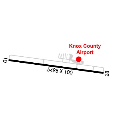
| Lat: N 4019.7 Long: W 08231.6 Elev: 1192 Var: +06 Longest Runway: 5504 | ||
| Clr Del: 119.45 AWOS: 126.05 CTAF: 123.05 | ||
| |||||||||||||||||||||||||||||||||||||||||||||||||||||||||||||
| |||||||||||||||||||||||||||||||||||||||||||||||||||||||||||||
| |||||||||||||||||||||||||||||||||||||||||||||||||||||||||||||
| Rwy | Rwy | |||||||
| 5504x100 | 5504' | 5504x100 | 5504' | |||||
| Runway ID | Single Wheel | Double Wheel | Double Tandem Wheel | Dual Double Wheel |
| 10/28 | 55,000 | 100,000 | N/A | N/A |
| These numbers are Advisory and are not limits. The Airport Manager should have more accurate Weight Limits | ||||
 Airport Diagram might not be current. | |
| Facility Name: | KNOX COUNTY |
| City Name: | MOUNT VERNON |
| County: | KNOX |
| State abbrev: | OH |
| State Name: | OHIO |
| Ownership: | PUBLICLY OWNED |
| Use: | OPEN TO THE PUBLIC |
| Owner's Name: | KNOX CO ARPT AUTHORITY |
| Address: | 6481 KINNEY RD |
| MOUNT VERNON, OH 43050-9301 | |
| Owner's Phone: | 740-397-9647 |
| Manager's Name: | JOSH WYNN; KNOXAIRPORT@EMBARQMAIL.COM. |
| Address: | 6481 KINNEY RD |
| MOUNT VERNON, OH 43050-9301 | |
| Phone: | 740-397-9647 |
| FAA Region: | GREAT LAKES |
| FAA Field Office: | DET |
| Date | Sunrise | Sunset |
|---|---|---|
| 04/25/24 Thursday | 6:36 | 20:20 |
| 04/26/24 Friday | 6:35 | 20:21 |
| 04/27/24 Saturday | 6:34 | 20:22 |
| 04/28/24 Sunday | 6:32 | 20:23 |
| 04/29/24 Monday | 6:31 | 20:24 |
| 04/30/24 Tuesday | 6:30 | 20:25 |
| 05/01/24 Wednesday | 6:29 | 20:26 |
| 05/02/24 Thursday | 6:27 | 20:27 |
| 05/03/24 Friday | 6:26 | 20:28 |
| 05/04/24 Saturday | 6:25 | 20:29 |
| 05/05/24 Sunday | 6:24 | 20:30 |
| 05/06/24 Monday | 6:23 | 20:31 |
| 05/07/24 Tuesday | 6:21 | 20:32 |
| 05/08/24 Wednesday | 6:20 | 20:33 |
| Airport Attendance Schedule | MON-FRI 0700-1700, SAT-SUN 0900-1700; 24 HR PN FOR ATNDNC AFT HRS - CALL AMGR. |
| Airport Status | OPERATIONAL (This Status can change at any time - please check NOTAMS) |
| Airport Lighting Schedule | ACTVT REIL RWY 10 & 28; MIRL RWY 10/28 - CTAF. PAPI RWY 10 & 28 OPR CONSLY. |
| Airport Storage Available | Tie Downs, Hanger |
| Extra Services Available | Crop Dusting, Flight Instruction, Aircraft Rental |
| Wind Indicator | YES - (lighted) |
| Control Tower | NO |
| CTAF Frequency | 123.050 |
| Unicom Frequency | 123.050 |
| Rotating Beacon Color | WG |
| Segmented Circle | NO |
| Landing Fee | NO |
| Airport Inspected | STATE - performed by STATE AERONAUTICAL PERSONNEL |
| Inspection Date | 08/02/2023 |
| Type of Fuel Available | Grade 100LL, JET A; -10FUEL AVBL H24 SELF SER VIA CREDIT CARD. |
| Airframe Repair Service | MAJOR |
| Power Plant Repair Service | MAJOR |
| Latitude | N4019.7 |
| Longitude | W08231.6 (ESTIMATED) |
| Arpt Elevation | 1191ft (SURVEYED) |
| Magnetic Variation | 06W |
| 4 miles SW | of MOUNT VERNON |
| Traffic Pattern Altitude | 808 |
| Sectional Chart | DETROIT |
| Operations (Reported) | Yearly | Avg. Daily |
|---|---|---|
| General Aviation Transient | 9500 | 26 |
| General Aviation Local | 14000 | 38 |
| Air Taxi | 500 | 1 |
| Commerical | 0 | 0 |
| Commuter | 0 | 0 |
| Military | 150 | 0 |
| Aircraft based on Field | |
|---|---|
| General Aviation Singles | 71 |
| General Aviation Multi | 3 |
| Jet Aircraft | 1 |
| General Aviation Helicopters | 0 |
| Military Aircraft | 0 |
| Gliders | 0 |
| Ultralights | 0 |
| FSS on field | NO |
| FSS tie-in | CLEVELAND |
| FSS Phone | 1-800-WX-BRIEF |
| Who issues Notams | CLE |
| Notam D service at airport | YES |
| ARTCC Name | INDIANAPOLIS |
| Airport Certification | |
| Aircraft Rescue & Firefighting Index | None |
| Airport of Entry | No |
| Custom Landing Rights | No |
| Joint Civil/Military | No |
| Military Landing rights | YES |
| NATIONAL PLAN OF INTEGRATED AIRPORT SYSTEMS (NPIAS) |
| ASSURANCES PURSUANT TO TITLE VI, CIVIL RIGHTS ACT OF 1964 |
| GRANT AGREEMENT HAS EXPIRED; HOWEVER, AGREEMENT REMAINS IN EFFECT FOR THIS FACILITY AS LONG AS IT IS PUBLIC USE. |
| DEER, BIRDS, & OTR WILDLIFE ON & INVOF ARPT. |
Airport Communications & Frequencies:
| ||||||||||||||||
| Runway: 10 | Runway: 28 | ||
| Mag heading: | 104° | Mag heading: | 284° |
| Rwy Slope: | -.05% Down | Rwy Slope: | .05% Up |
| Approach: | Approach: | ||
| Pattern: | Left Traffic | Pattern: | Left Traffic |
| Markings: | NONPRECISION INSTRUMENT | Markings: | NONPRECISION INSTRUMENT |
| Marking Condition: | GOOD | Marking Condition: | GOOD |
| Arresting Dev: | Arresting Dev: | ||
| Lat & Long: | N4019.8 W08232.2 | Lat. & Long.: | N4019.7 W08231.0 |
| Elev: | 1187.3 ft. MSL | Elev: | 1184.4 ft. MSL |
| TCH: | 40 ft. AGL | TCH: | 40 ft. AGL |
| Visual Glide Path: | 3.00 degrees | Visual Glide Path: | 3.00 degrees |
| Displaced Threshold: | No | Displaced Threshold: | No |
| Touchdown Zone: | YES | Touchdown Zone: | YES |
| Touchdown Elev.: | 1191.6 feet | Touchdown Elev.: | 1189.8 feet |
| Visual Glide Slope: | 4-Light PAPI on LEFT side of Runway | Visual Glide Slope: | 4-Light PAPI on LEFT side of Runway |
| RVR Equipment: | RVR Equipment: | ||
| RVV Equipment: | NO | RVV Equipment: | NO |
| Approach Lights: | Approach Lights: | ||
| REIL: | YES | REIL: | YES |
| Centerline Lights: | NO | Centerline Lights: | NO |
| Touchdown lights: | NO | Touchdown lights: | NO |
| Runway Category: | Runway with a Non-precision Approach having visibility minimums greater than 3/4 mile | Runway Category: | Runway with a Non-precision Approach having visibility minimums greater than 3/4 mile |
| Declared Distances: | Declared Distances: | ||
| Obstructions: | TREES | Obstructions: | TREES |
| Marked: | NOT Marked/Lighted | Marked: | NOT Marked/Lighted |
| Clearance slope: | 23:1 | Clearance slope: | 34:1 |
| Obstruction height: | 126 feet AGL | Obstruction height: | 51 feet AGL |
| Dist. from runway: | 3188 feet | Dist. from runway: | 1962 feet |
| Centerline offset: | 60 left of centerline | Centerline offset: | 65 feet left of centerline |
| Comments: | Comments: |
Thanks for using FltPlan.com
all rights reserved © 1999-2024 by Flight Plan LLC