
| SOUTH ALBANY SOUTH BETHLEHEM NY |
| |
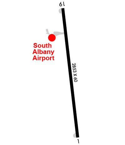
| Lat: N 4233.6 Long: W 07350.0 Elev: 196 Var: +14 Longest Runway: 2853 | ||
| CTAF: 122.9 | ||
| |||||||||||||||||||||||
| |||||||||||||||||||||||
| Rwy | Rwy | |||||||
| 2853x60 | 2703' | 2853x60 | 2729' | |||||
| Runway ID | Single Wheel | Double Wheel | Double Tandem Wheel | Dual Double Wheel |
| 01/19 | N/A | N/A | N/A | N/A |
| These numbers are Advisory and are not limits. The Airport Manager should have more accurate Weight Limits | ||||
 Airport Diagram might not be current. | |
| Facility Name: | SOUTH ALBANY |
| City Name: | SOUTH BETHLEHEM |
| County: | ALBANY |
| State abbrev: | NY |
| State Name: | NEW YORK |
| Ownership: | PRIVATELY OWNED |
| Use: | OPEN TO THE PUBLIC |
| Owner's Name: | SOUTH ALBANY CORP |
| Address: | 6 OLD SCHOOL ROAD |
| SELKIRK, NY 12158 | |
| Owner's Phone: | (518) 281-5430 |
| Manager's Name: | TED ZABINSKI |
| Address: | 6 OLD SCHOOL ROAD |
| SELKIRK, NY 12158 | |
| Phone: | (518) 281-5430 |
| FAA Region: | EASTERN |
| FAA Field Office: | NYC |
| Date | Sunrise | Sunset |
|---|---|---|
| 04/25/24 Thursday | 5:58 | 19:49 |
| 04/26/24 Friday | 5:56 | 19:51 |
| 04/27/24 Saturday | 5:55 | 19:52 |
| 04/28/24 Sunday | 5:53 | 19:53 |
| 04/29/24 Monday | 5:52 | 19:54 |
| 04/30/24 Tuesday | 5:50 | 19:55 |
| 05/01/24 Wednesday | 5:49 | 19:56 |
| 05/02/24 Thursday | 5:48 | 19:57 |
| 05/03/24 Friday | 5:46 | 19:58 |
| 05/04/24 Saturday | 5:45 | 20:00 |
| 05/05/24 Sunday | 5:44 | 20:01 |
| 05/06/24 Monday | 5:43 | 20:02 |
| 05/07/24 Tuesday | 5:41 | 20:03 |
| 05/08/24 Wednesday | 5:40 | 20:04 |
| Airport Attendance Schedule | NOV-MAR 7 Days A Week 0800-1600, APR-OCT 7 Days A Week 0600-2100 |
| Airport Status | OPERATIONAL (This Status can change at any time - please check NOTAMS) |
| Airport Lighting Schedule | ACTVT LIRL RWY 01/19; WDI LGT - CTAF. |
| Airport Storage Available | Hanger |
| Extra Services Available | Air Ambulance, Flight Instruction |
| Wind Indicator | YES - (lighted) |
| Control Tower | NO |
| CTAF Frequency | 122.900 |
| Unicom Frequency | |
| Rotating Beacon Color | |
| Segmented Circle | NO |
| Landing Fee | NO |
| Airport Inspected | STATE - performed by STATE AERONAUTICAL PERSONNEL |
| Inspection Date | 05/25/2022 |
| Type of Fuel Available | Grade 100LL, JET A (freeze point -40C) |
| Airframe Repair Service | MAJOR |
| Power Plant Repair Service | MAJOR |
| Latitude | N4233.6 |
| Longitude | W07350.0 (ESTIMATED) |
| Arpt Elevation | 195ft (SURVEYED) |
| Magnetic Variation | 14W |
| 2 miles N | of SOUTH BETHLEHEM |
| Traffic Pattern Altitude | |
| Sectional Chart | NEW YORK |
| Operations (Reported) | Yearly | Avg. Daily |
|---|---|---|
| General Aviation Transient | 7980 | 22 |
| General Aviation Local | 20000 | 55 |
| Air Taxi | 0 | 0 |
| Commerical | 0 | 0 |
| Commuter | 0 | 0 |
| Military | 520 | 1 |
| Aircraft based on Field | |
|---|---|
| General Aviation Singles | 21 |
| General Aviation Multi | 2 |
| Jet Aircraft | 0 |
| General Aviation Helicopters | 0 |
| Military Aircraft | 0 |
| Gliders | 0 |
| Ultralights | 0 |
| FSS on field | NO |
| FSS tie-in | BURLINGTON |
| FSS Phone | 1-800-WX-BRIEF |
| Who issues Notams | BTV |
| Notam D service at airport | YES |
| ARTCC Name | BOSTON |
| Airport Certification | |
| Aircraft Rescue & Firefighting Index | None |
| Airport of Entry | No |
| Custom Landing Rights | No |
| Joint Civil/Military | No |
| Military Landing rights | No |
| NATIONAL PLAN OF INTEGRATED AIRPORT SYSTEMS (NPIAS) |
| ARPT CLSD TO ACFT OVER 12500 LBS. |
| BIRDS ON AND INVOF ARPT. |
| HEL NOISE ABATEMENT PROC IN EFCT. VFR DEP MNTN RWY HDG TIL REACHING 500 FT AGL. AVOID ARR AND DEP TO/FM THE WEST. |
| 17 FT RAILROAD ACRS CNTRLN 200 FT S OF RWY 01 |
| FOR CD CTC ALBANY APCH AT 518-862-2299. |
Airport Communications & Frequencies:
| ||||||||||||
| Runway: 01 | Runway: 19 | ||
| Mag heading: | 7° | Mag heading: | 187° |
| Rwy Slope: | .39% Up | Rwy Slope: | -.39% Down |
| Approach: | Approach: | ||
| Pattern: | Left Traffic | Pattern: | Left Traffic |
| Markings: | NONPRECISION INSTRUMENT | Markings: | NONPRECISION INSTRUMENT |
| Marking Condition: | GOOD | Marking Condition: | GOOD |
| Arresting Dev: | Arresting Dev: | ||
| Lat & Long: | N4233.4 W07350.0 | Lat. & Long.: | N4233.9 W07350.1 |
| Elev: | 184.3 ft. MSL | Elev: | 195.3 ft. MSL |
| TCH: | TCH: | ||
| Visual Glide Path: | Visual Glide Path: | ||
| Displaced Threshold: | 150 feet | Displaced Threshold: | 124 feet |
| Touchdown Zone: | YES | Touchdown Zone: | YES |
| Touchdown Elev.: | 195.3 feet | Touchdown Elev.: | 195.3 feet |
| Visual Glide Slope: | Visual Glide Slope: | ||
| RVR Equipment: | TOUCHDOWN | RVR Equipment: | ROLLOUT |
| RVV Equipment: | NO | RVV Equipment: | NO |
| Approach Lights: | Approach Lights: | ||
| REIL: | NO | REIL: | NO |
| Centerline Lights: | NO | Centerline Lights: | NO |
| Touchdown lights: | NO | Touchdown lights: | NO |
| Runway Category: | Runway with a Non-precision Approach | Runway Category: | Runway with a Non-precision Approach |
| Declared Distances: | Declared Distances: | ||
| Obstructions: | FENCE | Obstructions: | ROAD |
| Marked: | NOT Marked/Lighted | Marked: | NOT Marked/Lighted |
| Clearance slope: | 1:1; RWY 1 CLNC SLOPE 13:1 TO DTHR DUE TO +27 FT TREE, 364 FT FM DTHR, 100 FT LEFT. | Clearance slope: | 6:1; CLNCE SLOPE 12:1 TO DTHR DUE TO +44 FT TREE, 535 FT FM DTHR, 177 FT L. |
| Obstruction height: | 27 feet AGL | Obstruction height: | 34 feet AGL |
| Dist. from runway: | 214 feet | Dist. from runway: | 420 feet |
| Centerline offset: | 100 left of centerline | Centerline offset: | 137 feet left of centerline |
| Comments: | +48 FT TREE, 90 FT FM RWY, 223 FT L. +26 FT TREE, 58 FT FM RWY, 144 FT L. +5 FT FENCE 125 FT R AND 115 FT L. | Comments: | +38 FT POLE, 182 FT FM RWY, 170 FT L. +50 FT POLE, 25 FT FM RWY, 194 FT R. +15 FT ROAD, 105 FT R. |
Thanks for using FltPlan.com
all rights reserved © 1999-2024 by Flight Plan LLC

