
| JERRY TYLER MEMORIAL NILES MI |
| |
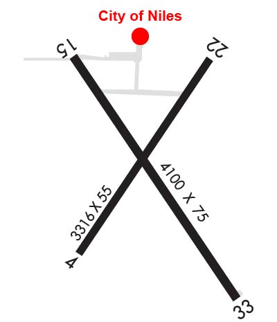
| Lat: N 4150.2 Long: W 08613.5 Elev: 750 Var: +05 Longest Runway: 4100 | ||
| CTAF: 122.8 | ||
| |||||||||||||||||||||||
| |||||||||||||||||||||||
| Rwy | Rwy | |||||||
| 3316x55 | 2418' | 3316x55 | 2566' | |||||
| 4100x75 | 3800' | 4100x75 | 4100' | |||||
| Runway ID | Single Wheel | Double Wheel | Double Tandem Wheel | Dual Double Wheel |
| 04/22 | 8,000 | N/A | N/A | N/A |
| 15/33 | 25,000 | N/A | N/A | N/A |
| These numbers are Advisory and are not limits. The Airport Manager should have more accurate Weight Limits | ||||
 Airport Diagram might not be current. | |
| Facility Name: | JERRY TYLER MEML |
| City Name: | NILES |
| County: | BERRIEN |
| State abbrev: | MI |
| State Name: | MICHIGAN |
| Ownership: | PUBLICLY OWNED |
| Use: | OPEN TO THE PUBLIC |
| Owner's Name: | CITY OF NILES |
| Address: | 333 N 2ND ST STE 301 |
| NILES, MI 49120-2258 | |
| Owner's Phone: | 269-683-4700 |
| Manager's Name: | JOSEPH RAY |
| Address: | 333 N 2ND ST STE 301 |
| NILES, MI 49120-2258 | |
| Phone: | 269-240-8025 |
| FAA Region: | GREAT LAKES |
| FAA Field Office: | DET |
| Date | Sunrise | Sunset |
|---|---|---|
| 04/25/24 Thursday | 6:48 | 20:38 |
| 04/26/24 Friday | 6:47 | 20:39 |
| 04/27/24 Saturday | 6:46 | 20:40 |
| 04/28/24 Sunday | 6:44 | 20:41 |
| 04/29/24 Monday | 6:43 | 20:42 |
| 04/30/24 Tuesday | 6:42 | 20:43 |
| 05/01/24 Wednesday | 6:40 | 20:44 |
| 05/02/24 Thursday | 6:39 | 20:45 |
| 05/03/24 Friday | 6:38 | 20:46 |
| 05/04/24 Saturday | 6:36 | 20:47 |
| 05/05/24 Sunday | 6:35 | 20:49 |
| 05/06/24 Monday | 6:34 | 20:50 |
| 05/07/24 Tuesday | 6:33 | 20:51 |
| 05/08/24 Wednesday | 6:32 | 20:52 |
| Airport Attendance Schedule | UNATTENDED |
| Airport Status | OPERATIONAL (This Status can change at any time - please check NOTAMS) |
| Airport Lighting Schedule | ACTVT REIL RWY 15 & 33; PAPI RWY 15 & 33; MIRL RWY 15/33 - CTAF. |
| Airport Storage Available | Tie Downs |
| Extra Services Available | Crop Dusting, Charter |
| Wind Indicator | YES - (lighted) |
| Control Tower | NO |
| CTAF Frequency | 122.800 |
| Unicom Frequency | 122.800 |
| Rotating Beacon Color | WG |
| Segmented Circle | YES |
| Landing Fee | NO |
| Airport Inspected | STATE - performed by STATE AERONAUTICAL PERSONNEL |
| Inspection Date | 04/19/2023 |
| Type of Fuel Available | Grade 100LL; -10SELF SVC FUEL. |
| Airframe Repair Service | None |
| Power Plant Repair Service | None |
| Latitude | N4150.2 |
| Longitude | W08613.5 (ESTIMATED) |
| Arpt Elevation | 750ft (SURVEYED) |
| Magnetic Variation | 05W |
| 2 miles NE | of NILES |
| Traffic Pattern Altitude | |
| Sectional Chart | CHICAGO |
| Operations (Reported) | Yearly | Avg. Daily |
|---|---|---|
| General Aviation Transient | 1500 | 4 |
| General Aviation Local | 1500 | 4 |
| Air Taxi | 0 | 0 |
| Commerical | 0 | 0 |
| Commuter | 0 | 0 |
| Military | 24 | 0 |
| Aircraft based on Field | |
|---|---|
| General Aviation Singles | 25 |
| General Aviation Multi | 2 |
| Jet Aircraft | 0 |
| General Aviation Helicopters | 1 |
| Military Aircraft | 0 |
| Gliders | 0 |
| Ultralights | 0 |
| FSS on field | NO |
| FSS tie-in | LANSING |
| FSS Phone | 1-800-WX-BRIEF |
| Who issues Notams | LAN |
| Notam D service at airport | YES |
| ARTCC Name | CHICAGO |
| Airport Certification | |
| Aircraft Rescue & Firefighting Index | None |
| Airport of Entry | No |
| Custom Landing Rights | No |
| Joint Civil/Military | No |
| Military Landing rights | YES |
| NATIONAL PLAN OF INTEGRATED AIRPORT SYSTEMS (NPIAS) |
| GRANT AGREEMENT HAS EXPIRED; HOWEVER, AGREEMENT REMAINS IN EFFECT FOR THIS FACILITY AS LONG AS IT IS PUBLIC USE. |
| RWY 15 TRSN ZONE +51 FT OBSTN LGTD POLES. |
| TREES BTN RYS 04 & 33 BTN RYS 33 & 22 OBSTRUCT VIEW OF RY ENDS. |
| GCO AVBL ON FREQ 121.725 THRU SBN CD & FLT SVCS. |
| FOR CD IF UNA VIA GCO CTC SOUTH BEND APCH AT 574-251-2609. WHEN SOUTH BEND APCH CLSD, FOR CD CTC CHICAGO ARTCC AT 630-906-8921. |
| RWY 04/2 2 CRACKED & BROKEN PAVEMENT. |
| RWY 15/3 3 NMRS CRACKS IN PAVEMENT. |
Airport Communications & Frequencies:
| |||||||||||||||||
| Runway: 04 | Runway: 22 | ||
| Mag heading: | 39° | Mag heading: | 219° |
| Rwy Slope: | .15% Up | Rwy Slope: | -.15% Down |
| Approach: | Approach: | ||
| Pattern: | Left Traffic | Pattern: | Left Traffic |
| Markings: | NONE | Markings: | NONE |
| Marking Condition: | Marking Condition: | ||
| Arresting Dev: | Arresting Dev: | ||
| Lat & Long: | N4150.0 W08613.7 | Lat. & Long.: | N4150.4 W08613.3 |
| Elev: | 736.9 ft. MSL | Elev: | 741.9 ft. MSL |
| TCH: | TCH: | ||
| Visual Glide Path: | Visual Glide Path: | ||
| Displaced Threshold: | 898 feet | Displaced Threshold: | 750 feet |
| Touchdown Zone: | YES | Touchdown Zone: | YES |
| Touchdown Elev.: | 741.9 feet | Touchdown Elev.: | 741.9 feet |
| Visual Glide Slope: | Visual Glide Slope: | ||
| RVR Equipment: | RVR Equipment: | ||
| RVV Equipment: | NO | RVV Equipment: | NO |
| Approach Lights: | Approach Lights: | ||
| REIL: | NO | REIL: | NO |
| Centerline Lights: | NO | Centerline Lights: | NO |
| Touchdown lights: | NO | Touchdown lights: | NO |
| Runway Category: | Runway with a Visual Approach | Runway Category: | Runway with a Visual Approach |
| Declared Distances: | Declared Distances: | ||
| Obstructions: | TREE | Obstructions: | TREES |
| Marked: | NOT Marked/Lighted | Marked: | NOT Marked/Lighted |
| Clearance slope: | CTLG OBSTN EXCEEDS A 45 DEG SLP. | Clearance slope: | 3:1; APCH RATIO 16:1 TO DTHR OVR 80 FT TREES, 1320 FT DIST, 255 FT R. |
| Obstruction height: | 13 feet AGL | Obstruction height: | 66 feet AGL |
| Dist. from runway: | 200 feet | Dist. from runway: | 454 feet |
| Centerline offset: | 110 left of centerline | Centerline offset: | 70 feet right of centerline |
| Comments: | 13 FT TREE, 199 FT DIST, 110 FT L. | Comments: |
| Runway: 15 | Runway: 33 | ||
| Mag heading: | 151° | Mag heading: | 331° |
| Rwy Slope: | .22% Up | Rwy Slope: | -.22% Down |
| Approach: | Approach: | ||
| Pattern: | Left Traffic | Pattern: | Left Traffic |
| Markings: | BASIC | Markings: | BASIC |
| Marking Condition: | GOOD | Marking Condition: | GOOD |
| Arresting Dev: | Arresting Dev: | ||
| Lat & Long: | N4150.4 W08613.7 | Lat. & Long.: | N4149.9 W08613.2 |
| Elev: | 741.4 ft. MSL | Elev: | 750.4 ft. MSL |
| TCH: | 35 ft. AGL | TCH: | 37 ft. AGL |
| Visual Glide Path: | 4.00 degrees | Visual Glide Path: | 4.00 degrees |
| Displaced Threshold: | 300 feet | Displaced Threshold: | No |
| Touchdown Zone: | YES | Touchdown Zone: | YES |
| Touchdown Elev.: | 741.8 feet | Touchdown Elev.: | 750.4 feet |
| Visual Glide Slope: | 4-Light PAPI on LEFT side of Runway; PAPI UNUSBL BYD 5 DEGS LEFT OR RIGHT OF CNTRLN. | Visual Glide Slope: | 4-Light PAPI on LEFT side of Runway; PAPI UNUSBL BYD 3 DEGS LEFT OR RIGHT OF CNTRLN. |
| RVR Equipment: | RVR Equipment: | ||
| RVV Equipment: | NO | RVV Equipment: | NO |
| Approach Lights: | Approach Lights: | ||
| REIL: | YES | REIL: | YES |
| Centerline Lights: | NO | Centerline Lights: | NO |
| Touchdown lights: | NO | Touchdown lights: | NO |
| Runway Category: | Runway with a Non-precision Approach | Runway Category: | Runway with a Non-precision Approach |
| Declared Distances: | Declared Distances: | ||
| Obstructions: | TREE | Obstructions: | TREES |
| Marked: | LIGHTED | Marked: | NOT Marked/Lighted |
| Clearance slope: | 4:1; APCH RATIO 12:1 TO DTHR OVR 63 FT TREE, 791 FT DIST, 270 FT R. | Clearance slope: | CTLG OBSTN EXCEEDS A 45 DEG SLP. |
| Obstruction height: | 63 feet AGL | Obstruction height: | 45 feet AGL |
| Dist. from runway: | 502 feet | Dist. from runway: | 200 feet |
| Centerline offset: | 250 left of centerline | Centerline offset: | 240 feet right of centerline |
| Comments: | Comments: |
Thanks for using FltPlan.com
all rights reserved © 1999-2024 by Flight Plan LLC

