
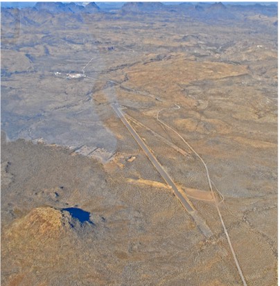
| BIG BEND RANCH STATE PARK- PVT PRESIDIO TX |
| |
| Lat: N 2928.3 Long: W 10356.2 Elev: 4250 Var: -09 Longest Runway: 5500 | ||
| CTAF: 122.9 | ||
| |||||
|
| Rwy | Rwy | |||||||
| 5500x80 | 5500' | 5500x80 | 5500' | |||||
| Runway ID | Single Wheel | Double Wheel | Double Tandem Wheel | Dual Double Wheel |
| 08/26 | N/A | N/A | N/A | N/A |
| These numbers are Advisory and are not limits. The Airport Manager should have more accurate Weight Limits | ||||
| FltPlan does not have IFR approach charts available for K3T9. |
| Facility Name: | BIG BEND RANCH STATE PARK |
| City Name: | PRESIDIO |
| County: | PRESIDIO |
| State abbrev: | TX |
| State Name: | TEXAS |
| Ownership: | PUBLICLY OWNED |
| Use: | OPEN TO THE PUBLIC |
| Owner's Name: | PARKS & WILDLIFE DEPT |
| Address: | 4200 SMITH SCHOOL RD |
| AUSTIN, TX 78744 | |
| Owner's Phone: | 512-389-4802 |
| Manager's Name: | DAVID RENNINGER II; PARK SUPERINTENDENT. |
| Address: | 1900 SOUTH SAUCEDA RANCH RD |
| MARFA, TX 79843 | |
| Phone: | 432-358-4444; EXT 224. 432-295-0888 CELL. |
| FAA Region: | SOUTHWEST |
| FAA Field Office: | TEX |
| Date | Sunrise | Sunset |
|---|---|---|
| 04/26/24 Friday | 7:17 | 20:30 |
| 04/27/24 Saturday | 7:17 | 20:30 |
| 04/28/24 Sunday | 7:16 | 20:31 |
| 04/29/24 Monday | 7:15 | 20:32 |
| 04/30/24 Tuesday | 7:14 | 20:32 |
| 05/01/24 Wednesday | 7:13 | 20:33 |
| 05/02/24 Thursday | 7:12 | 20:34 |
| 05/03/24 Friday | 7:11 | 20:34 |
| 05/04/24 Saturday | 7:11 | 20:35 |
| 05/05/24 Sunday | 7:10 | 20:35 |
| 05/06/24 Monday | 7:09 | 20:36 |
| 05/07/24 Tuesday | 7:08 | 20:37 |
| 05/08/24 Wednesday | 7:07 | 20:37 |
| 05/09/24 Thursday | 7:07 | 20:38 |
| Airport Attendance Schedule | UNATTENDED |
| Airport Status | OPERATIONAL (This Status can change at any time - please check NOTAMS) |
| Airport Lighting Schedule | |
| Airport Storage Available | NONE |
| Extra Services Available | NONE |
| Wind Indicator | YES - (unlit) |
| Control Tower | NO |
| CTAF Frequency | 122.900 |
| Unicom Frequency | |
| Rotating Beacon Color | |
| Segmented Circle | NO |
| Landing Fee | NO |
| Airport Inspected | 5010-2 PRIVATE USE MAILOUT PROGRAM - performed by PRIVATE CONTRACT PERSONNEL |
| Inspection Date | 03/08/2024 |
| Type of Fuel Available | None |
| Airframe Repair Service | NONE |
| Power Plant Repair Service | NONE |
| Latitude | N2928.3 |
| Longitude | W10356.2 (ESTIMATED) |
| Arpt Elevation | 4250ft (ESTIMATED) |
| Magnetic Variation | 09E |
| 23 miles E | of PRESIDIO |
| Traffic Pattern Altitude | |
| Sectional Chart | EL PASO |
| Operations (Reported) | Yearly | Avg. Daily |
|---|---|---|
| General Aviation Transient | 80 | 0 |
| General Aviation Local | 0 | 0 |
| Air Taxi | 0 | 0 |
| Commerical | 0 | 0 |
| Commuter | 0 | 0 |
| Military | 0 | 0 |
| Aircraft based on Field | |
|---|---|
| General Aviation Singles | 1 |
| General Aviation Multi | 0 |
| Jet Aircraft | 0 |
| General Aviation Helicopters | 0 |
| Military Aircraft | 0 |
| Gliders | 0 |
| Ultralights | 0 |
| FSS on field | NO |
| FSS tie-in | SAN ANGELO |
| FSS Phone | 1-800-WX-BRIEF |
| Who issues Notams | SJT |
| Notam D service at airport | YES |
| ARTCC Name | ALBUQUERQUE |
| Airport Certification | |
| Aircraft Rescue & Firefighting Index | None |
| Airport of Entry | No |
| Custom Landing Rights | No |
| Joint Civil/Military | No |
| Military Landing rights | No |
| ARPT LCTD 26 MILES FROM RANCH GATE; ROAD VERY ROUGH. |
| FOR CD CTC ALBUQUERQUE ARTCC AT 505-856-4861. |
| REMOTE AREA, NO CELL PHONE COVERAGE. |
| UPON ARRIVAL, CHECK IN AT RANGER STATION, 1 MILE FROM ARPT. |
| RWY 08/2 6 LOOSE STONES ON RWY. |
| Runway: 08 | Runway: 26 | ||
| Mag heading: | 81° | Mag heading: | 261° |
| Rwy Slope: | .00% | Rwy Slope: | .00% |
| Approach: | Approach: | ||
| Pattern: | Left Traffic | Pattern: | Left Traffic |
| Markings: | Markings: | ||
| Marking Condition: | Marking Condition: | ||
| Arresting Dev: | Arresting Dev: | ||
| Lat & Long: | N2928.3 W10356.7 | Lat. & Long.: | N2928.3 W10355.7 |
| Elev: | 4250.0 ft. MSL | Elev: | 4250.0 ft. MSL |
| TCH: | TCH: | ||
| Visual Glide Path: | Visual Glide Path: | ||
| Displaced Threshold: | No | Displaced Threshold: | No |
| Touchdown Zone: | NO | Touchdown Zone: | NO |
| Touchdown Elev.: | Touchdown Elev.: | ||
| Visual Glide Slope: | Visual Glide Slope: | ||
| RVR Equipment: | RVR Equipment: | ||
| RVV Equipment: | NO | RVV Equipment: | NO |
| Approach Lights: | Approach Lights: | ||
| REIL: | NO | REIL: | NO |
| Centerline Lights: | NO | Centerline Lights: | NO |
| Touchdown lights: | NO | Touchdown lights: | NO |
| Runway Category: | Runway with a Visual Approach | Runway Category: | Runway with a Visual Approach |
| Declared Distances: | Declared Distances: | ||
| Obstructions: | BRUSH; HILLS SURROUNDING ARPT. | Obstructions: | BRUSH |
| Marked: | NOT Marked/Lighted | Marked: | NOT Marked/Lighted |
| Clearance slope: | 10 FT BRUSH. | Clearance slope: | |
| Obstruction height: | 10 feet AGL | Obstruction height: | 10 feet AGL |
| Dist. from runway: | 200 feet | Dist. from runway: | 200 feet |
| Centerline offset: | Centerline offset: | ||
| Comments: | 10 FT BRUSH AT RWY EDGE. | Comments: | 10 FT BRUSH AT RWY EDGE. |
Thanks for using FltPlan.com
all rights reserved © 1999-2024 by Flight Plan LLC