
| WADSWORTH MUNI WADSWORTH OH |
| |
| Lat: N 4100.2 Long: W 08145.4 Elev: 974 Var: +07 Longest Runway: 3530 | ||
| CTAF: 122.8 | ||
| |||||||||||||||||||||||||||||||||||||||||||||||||||||||||||||||||||||
| |||||||||||||||||||||||||||||||||||||||||||||||||||||||||||||||||||||
| Rwy | Rwy | |||||||
| 3530x75 | 3400' | 3530x75 | 3530' | |||||
| 2155x35 | 2155' | 2155x35 | 2155' | |||||
| Runway ID | Single Wheel | Double Wheel | Double Tandem Wheel | Dual Double Wheel |
| 02/20 | N/A | N/A | N/A | N/A |
| 10/28 | N/A | N/A | N/A | N/A |
| These numbers are Advisory and are not limits. The Airport Manager should have more accurate Weight Limits | ||||
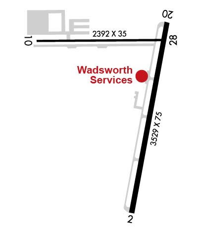 Airport Diagram might not be current. | |
| Facility Name: | WADSWORTH MUNI |
| City Name: | WADSWORTH |
| County: | MEDINA |
| State abbrev: | OH |
| State Name: | OHIO |
| Ownership: | PUBLICLY OWNED |
| Use: | OPEN TO THE PUBLIC |
| Owner's Name: | CITY OF WADSWORTH ARPT COMMISSION |
| Address: | WADSWORTH MUNICIPAL BLDG, 120 MAPLE ST |
| WADSWORTH, OH 44281-1825 | |
| Owner's Phone: | 330-335-1521 |
| Manager's Name: | MARK MILLER |
| Address: | 840 AIRPORT DR |
| WADSWORTH, OH 44281-9552 | |
| Phone: | 330-334-9861; OR 330-241-2562. |
| FAA Region: | GREAT LAKES |
| FAA Field Office: | DET |
| Date | Sunrise | Sunset |
|---|---|---|
| 04/25/24 Thursday | 6:32 | 20:18 |
| 04/26/24 Friday | 6:31 | 20:19 |
| 04/27/24 Saturday | 6:29 | 20:20 |
| 04/28/24 Sunday | 6:28 | 20:21 |
| 04/29/24 Monday | 6:27 | 20:22 |
| 04/30/24 Tuesday | 6:25 | 20:24 |
| 05/01/24 Wednesday | 6:24 | 20:25 |
| 05/02/24 Thursday | 6:23 | 20:26 |
| 05/03/24 Friday | 6:22 | 20:27 |
| 05/04/24 Saturday | 6:20 | 20:28 |
| 05/05/24 Sunday | 6:19 | 20:29 |
| 05/06/24 Monday | 6:18 | 20:30 |
| 05/07/24 Tuesday | 6:17 | 20:31 |
| 05/08/24 Wednesday | 6:16 | 20:32 |
| Airport Attendance Schedule | CONTINUOUS |
| Airport Status | OPERATIONAL (This Status can change at any time - please check NOTAMS) |
| Airport Lighting Schedule | ACTVT MIRL RWY 02/20 - CTAF. VASI RWY 02 & 20 OPR CONSLY. |
| Airport Storage Available | Tie Downs, Hanger |
| Extra Services Available | Charter, Glider, Flight Instruction, Aircraft Rental, Glider Towing |
| Wind Indicator | YES - (lighted) |
| Control Tower | NO |
| CTAF Frequency | 122.800 |
| Unicom Frequency | 122.800 |
| Rotating Beacon Color | WG |
| Segmented Circle | NO |
| Landing Fee | NO |
| Airport Inspected | STATE - performed by STATE AERONAUTICAL PERSONNEL |
| Inspection Date | 10/15/2020 |
| Type of Fuel Available | Grade 100LL, JET A-1 (icing inhibitor, freeze point -50C) |
| Airframe Repair Service | MAJOR |
| Power Plant Repair Service | MAJOR |
| Latitude | N4100.2 |
| Longitude | W08145.4 (ESTIMATED) |
| Arpt Elevation | 973ft (SURVEYED) |
| Magnetic Variation | 07W |
| 2 miles SW | of WADSWORTH |
| Traffic Pattern Altitude | |
| Sectional Chart | DETROIT |
| Operations (Reported) | Yearly | Avg. Daily |
|---|---|---|
| General Aviation Transient | 12000 | 33 |
| General Aviation Local | 30000 | 82 |
| Air Taxi | 500 | 1 |
| Commerical | 0 | 0 |
| Commuter | 0 | 0 |
| Military | 50 | 0 |
| Aircraft based on Field | |
|---|---|
| General Aviation Singles | 84 |
| General Aviation Multi | 6 |
| Jet Aircraft | 0 |
| General Aviation Helicopters | 1 |
| Military Aircraft | 0 |
| Gliders | 4 |
| Ultralights | 0 |
| FSS on field | NO |
| FSS tie-in | CLEVELAND |
| FSS Phone | 1-800-WX-BRIEF |
| Who issues Notams | CLE |
| Notam D service at airport | YES |
| ARTCC Name | CLEVELAND |
| Airport Certification | |
| Aircraft Rescue & Firefighting Index | None |
| Airport of Entry | No |
| Custom Landing Rights | No |
| Joint Civil/Military | No |
| Military Landing rights | No |
| NATIONAL PLAN OF INTEGRATED AIRPORT SYSTEMS (NPIAS) |
| CAUTION: EXTSV HEL OPS. |
| RWY 02 TFC PAT PREFERRED ENTRY AT 45 DEGS TO UPWIND LEG TO AVOID TFC AT 15G ARPT 2.5 NM NW. |
| RWY 10 CLSD FOR DEPARTURE WHEN WIND LESS THAN 15 KTS FM THE EAST. |
| NO LINE OF SIGHT BTN RWY'S 02 & 10. |
| RWY 20 CALM WIND RWY BLO 4 KTS FOR NOISE ABATEMENT. AVOID HOSPITAL TO THE N. |
| FOR CD CTC CLEVELAND APCH AT 216-352-2323, WHEN APCH CLSD CTC CLEVELAND ARTCC AT 440-774-0223. |
| TWY B CLSD TO PWRD ACFT |
| BIRDS, DEER, & OTR WILDLIFE ON & INVOF ARPT. |
| CAUTION: GLIDER OPS ALL RWY'S |
Airport Communications & Frequencies:
| |||||||||||||||||
| Runway: 02 | Runway: 20 | ||
| Mag heading: | 18° | Mag heading: | 198° |
| Rwy Slope: | .24% Up | Rwy Slope: | -.24% Down |
| Approach: | Approach: | ||
| Pattern: | Left Traffic | Pattern: | Left Traffic |
| Markings: | NONPRECISION INSTRUMENT | Markings: | NONPRECISION INSTRUMENT |
| Marking Condition: | FAIR | Marking Condition: | FAIR |
| Arresting Dev: | Arresting Dev: | ||
| Lat & Long: | N4059.8 W08145.4 | Lat. & Long.: | N4100.4 W08145.2 |
| Elev: | 965.0 ft. MSL | Elev: | 973.6 ft. MSL |
| TCH: | 24 ft. AGL | TCH: | 24 ft. AGL |
| Visual Glide Path: | 3.50 degrees | Visual Glide Path: | 3.50 degrees |
| Displaced Threshold: | 130 feet | Displaced Threshold: | No |
| Touchdown Zone: | YES | Touchdown Zone: | YES |
| Touchdown Elev.: | 972.3 feet | Touchdown Elev.: | 973.7 feet |
| Visual Glide Slope: | 2-Box VASI on RIGHT side of Runway | Visual Glide Slope: | 2-Box VASI on LEFT side of Runway |
| RVR Equipment: | RVR Equipment: | ||
| RVV Equipment: | NO | RVV Equipment: | NO |
| Approach Lights: | Approach Lights: | ||
| REIL: | NO | REIL: | NO |
| Centerline Lights: | NO | Centerline Lights: | NO |
| Touchdown lights: | NO | Touchdown lights: | NO |
| Runway Category: | Runway with a Non-precision Approach | Runway Category: | Runway with a Non-precision Approach |
| Declared Distances: | Declared Distances: | ||
| Obstructions: | FENCE | Obstructions: | FENCE |
| Marked: | NOT Marked/Lighted | Marked: | NOT Marked/Lighted |
| Clearance slope: | Clearance slope: | ||
| Obstruction height: | 4 feet AGL | Obstruction height: | 4 feet AGL |
| Dist. from runway: | 201 feet | Dist. from runway: | 201 feet |
| Centerline offset: | 175 right of centerline | Centerline offset: | 233 feet left of centerline |
| Comments: | +4 FT FENCE, 0-200 FT DIST, 175-220 FT R, OBST CLNC SLP 0:1 TO DTHR. | Comments: | +4 FT FENCE, 85-200 FT DIST, 233-250 FT L, OBST CLNC SLP 0:1. |
| Runway: 10 | Runway: 28 | ||
| Mag heading: | 97° | Mag heading: | 277° |
| Rwy Slope: | .39% Up | Rwy Slope: | -.39% Down |
| Approach: | Approach: | ||
| Pattern: | Left Traffic | Pattern: | Left Traffic |
| Markings: | BASIC | Markings: | BASIC |
| Marking Condition: | GOOD | Marking Condition: | GOOD |
| Arresting Dev: | Arresting Dev: | ||
| Lat & Long: | N4100.3 W08145.8 | Lat. & Long.: | N4100.3 W08145.3 |
| Elev: | 962.8 ft. MSL | Elev: | 971.1 ft. MSL |
| TCH: | TCH: | ||
| Visual Glide Path: | Visual Glide Path: | ||
| Displaced Threshold: | No | Displaced Threshold: | No |
| Touchdown Zone: | YES | Touchdown Zone: | YES |
| Touchdown Elev.: | 971.1 feet | Touchdown Elev.: | 971.1 feet |
| Visual Glide Slope: | Visual Glide Slope: | ||
| RVR Equipment: | RVR Equipment: | ||
| RVV Equipment: | NO | RVV Equipment: | NO |
| Approach Lights: | Approach Lights: | ||
| REIL: | NO | REIL: | NO |
| Centerline Lights: | NO | Centerline Lights: | NO |
| Touchdown lights: | NO | Touchdown lights: | NO |
| Runway Category: | Runway with a Visual Approach | Runway Category: | Runway with a Visual Approach |
| Declared Distances: | Declared Distances: | ||
| Obstructions: | POLE | Obstructions: | TREE |
| Marked: | NOT Marked/Lighted | Marked: | NOT Marked/Lighted |
| Clearance slope: | 2:1 | Clearance slope: | 7:1 |
| Obstruction height: | 31 feet AGL | Obstruction height: | 90 feet AGL |
| Dist. from runway: | 281 feet | Dist. from runway: | 859 feet |
| Centerline offset: | 125 right of centerline | Centerline offset: | 158 feet left of centerline |
| Comments: | +20 FT TWY, 0-185 FT DIST, 100 FT L; +20 FT TWY, 0-85 FT DIST, 110 FT R. | Comments: |
Thanks for using FltPlan.com
all rights reserved © 1999-2024 by Flight Plan LLC


