
| CHOWCHILLA CHOWCHILLA CA |
| |
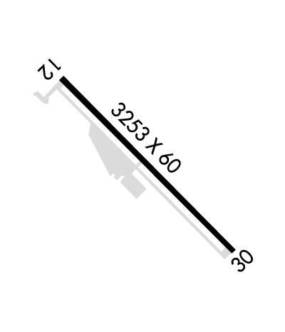
| Lat: N 3706.8 Long: W 12014.8 Elev: 243 Var: -15 Longest Runway: 3253 | ||
| CTAF: 122.9 | ||
| ||||||||||||||||||||||||||||||||
| ||||||||||||||||||||||||||||||||
| Rwy | Rwy | |||||||
| 3253x60 | 3253' | 3253x60 | 3253' | |||||
| Runway ID | Single Wheel | Double Wheel | Double Tandem Wheel | Dual Double Wheel |
| 12/30 | 12,000 | N/A | N/A | N/A |
| These numbers are Advisory and are not limits. The Airport Manager should have more accurate Weight Limits | ||||
| FltPlan does not have IFR approach charts available for K2O6. |
 Airport Diagram might not be current. | |
| Facility Name: | CHOWCHILLA |
| City Name: | CHOWCHILLA |
| County: | MADERA |
| State abbrev: | CA |
| State Name: | CALIFORNIA |
| Ownership: | PUBLICLY OWNED |
| Use: | OPEN TO THE PUBLIC |
| Owner's Name: | CITY OF CHOWCHILLA |
| Address: | 130 SOUTH 2ND STREET |
| CHOWCHILLA, CA 93610 | |
| Owner's Phone: | 559-665-8615 |
| Manager's Name: | JASON ROGERS |
| Address: | 130 SOUTH 2ND STREET |
| CHOWCHILLA, CA 93610 | |
| Phone: | (559) 267-3157; EXT 300 |
| FAA Region: | WESTERN-PACIFIC |
| FAA Field Office: | SFO |
| Date | Sunrise | Sunset |
|---|---|---|
| 04/25/24 Thursday | 6:13 | 19:46 |
| 04/26/24 Friday | 6:11 | 19:47 |
| 04/27/24 Saturday | 6:10 | 19:47 |
| 04/28/24 Sunday | 6:09 | 19:48 |
| 04/29/24 Monday | 6:08 | 19:49 |
| 04/30/24 Tuesday | 6:07 | 19:50 |
| 05/01/24 Wednesday | 6:05 | 19:51 |
| 05/02/24 Thursday | 6:04 | 19:52 |
| 05/03/24 Friday | 6:03 | 19:53 |
| 05/04/24 Saturday | 6:02 | 19:54 |
| 05/05/24 Sunday | 6:01 | 19:55 |
| 05/06/24 Monday | 6:00 | 19:55 |
| 05/07/24 Tuesday | 5:59 | 19:56 |
| 05/08/24 Wednesday | 5:58 | 19:57 |
| Airport Attendance Schedule | UNATTENDED |
| Airport Status | OPERATIONAL (This Status can change at any time - please check NOTAMS) |
| Airport Lighting Schedule | ACTVT MIRL RY 12/30 - CTAF. |
| Airport Storage Available | Tie Downs |
| Extra Services Available | Crop Dusting |
| Wind Indicator | YES - (lighted) |
| Control Tower | NO |
| CTAF Frequency | 122.900 |
| Unicom Frequency | |
| Rotating Beacon Color | |
| Segmented Circle | YES |
| Landing Fee | NO |
| Airport Inspected | STATE - performed by STATE AERONAUTICAL PERSONNEL |
| Inspection Date | 06/22/2023 |
| Type of Fuel Available | None |
| Airframe Repair Service | None |
| Power Plant Repair Service | None |
| Latitude | N3706.8 |
| Longitude | W12014.8 (ESTIMATED) |
| Arpt Elevation | 243ft (ESTIMATED) |
| Magnetic Variation | 15E |
| 1 miles SE | of CHOWCHILLA |
| Traffic Pattern Altitude | |
| Sectional Chart | SAN FRANCISCO |
| Operations (Reported) | Yearly | Avg. Daily |
|---|---|---|
| General Aviation Transient | 2000 | 5 |
| General Aviation Local | 4700 | 13 |
| Air Taxi | 0 | 0 |
| Commerical | 0 | 0 |
| Commuter | 0 | 0 |
| Military | 0 | 0 |
| Aircraft based on Field | |
|---|---|
| General Aviation Singles | 16 |
| General Aviation Multi | 1 |
| Jet Aircraft | 0 |
| General Aviation Helicopters | 1 |
| Military Aircraft | 0 |
| Gliders | 0 |
| Ultralights | 0 |
| FSS on field | NO |
| FSS tie-in | RANCHO MURIETA |
| FSS Phone | 1-800-WX-BRIEF |
| Who issues Notams | RIU |
| Notam D service at airport | YES |
| ARTCC Name | OAKLAND |
| Airport Certification | |
| Aircraft Rescue & Firefighting Index | None |
| Airport of Entry | No |
| Custom Landing Rights | No |
| Joint Civil/Military | No |
| Military Landing rights | YES |
| NATIONAL PLAN OF INTEGRATED AIRPORT SYSTEMS (NPIAS) |
| GRANT AGREEMENTS UNDER FAAP/ADAP/AIP |
| ASSURANCES PURSUANT TO TITLE VI, CIVIL RIGHTS ACT OF 1964 |
| APCH TO RWY 12 +35' POWERLINES 1150' FM THR ON EXTNDD RY CNTRLN. |
| FOR CD CTC NORCAL APCH AT 916-361-0516. |
| RWY 12/3 0 300 FT STOPWAYS AT BOTH ENDS OF RY. |
| Runway: 12 | Runway: 30 | ||
| Mag heading: | 119° | Mag heading: | 299° |
| Rwy Slope: | .15% Up | Rwy Slope: | -.15% Down |
| Approach: | Approach: | ||
| Pattern: | Left Traffic | Pattern: | Right Traffic |
| Markings: | BASIC | Markings: | BASIC |
| Marking Condition: | FAIR | Marking Condition: | FAIR |
| Arresting Dev: | Arresting Dev: | ||
| Lat & Long: | N3707.0 W12015.1 | Lat. & Long.: | N3706.6 W12014.6 |
| Elev: | 238.2 ft. MSL | Elev: | 243.0 ft. MSL |
| TCH: | TCH: | ||
| Visual Glide Path: | Visual Glide Path: | ||
| Displaced Threshold: | No | Displaced Threshold: | No |
| Touchdown Zone: | YES | Touchdown Zone: | YES |
| Touchdown Elev.: | 242.4 feet | Touchdown Elev.: | 243.0 feet |
| Visual Glide Slope: | Visual Glide Slope: | ||
| RVR Equipment: | RVR Equipment: | ||
| RVV Equipment: | NO | RVV Equipment: | NO |
| Approach Lights: | Approach Lights: | ||
| REIL: | NO | REIL: | NO |
| Centerline Lights: | NO | Centerline Lights: | NO |
| Touchdown lights: | NO | Touchdown lights: | NO |
| Runway Category: | Runway with a Visual Approach | Runway Category: | Runway with a Visual Approach |
| Declared Distances: | Declared Distances: | ||
| Obstructions: | ANT | Obstructions: | RR |
| Marked: | NOT Marked/Lighted | Marked: | NOT Marked/Lighted |
| Clearance slope: | 21:1 | Clearance slope: | 22:1 |
| Obstruction height: | 60 feet AGL | Obstruction height: | 24 feet AGL |
| Dist. from runway: | 1500 feet | Dist. from runway: | 750 feet |
| Centerline offset: | 100 right of centerline | Centerline offset: | |
| Comments: | Comments: |
Thanks for using FltPlan.com
all rights reserved © 1999-2024 by Flight Plan LLC
