
| HIGGINS-LIPSCOMB COUNTY HIGGINS TX |
| |
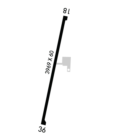
| Lat: N 3606.4 Long: W 10001.5 Elev: 2566 Var: -08 Longest Runway: 3969 | ||
| CTAF: 122.9 | ||
| ||||||||||||||||||||||||||||||||
| ||||||||||||||||||||||||||||||||
| Rwy | Rwy | |||||||
| 3969x60 | 3773' | 3969x60 | 3969' | |||||
| Runway ID | Single Wheel | Double Wheel | Double Tandem Wheel | Dual Double Wheel |
| 18/36 | 12,500 | N/A | N/A | N/A |
| These numbers are Advisory and are not limits. The Airport Manager should have more accurate Weight Limits | ||||
 Airport Diagram might not be current. | |
| Facility Name: | HIGGINS/LIPSCOMB COUNTY |
| City Name: | HIGGINS |
| County: | LIPSCOMB |
| State abbrev: | TX |
| State Name: | TEXAS |
| Ownership: | PUBLICLY OWNED |
| Use: | OPEN TO THE PUBLIC |
| Owner's Name: | LIPSCOMB CO. |
| Address: | COUNTY COURTHOUSE |
| LIPSCOMB, TX 79056 | |
| Owner's Phone: | 806-862-4131 |
| Manager's Name: | DAN COCKRELL |
| Address: | COUNTY COURTHOUSE |
| LIPSCOMB, TX 79056 | |
| Phone: | 806-862-4131 |
| FAA Region: | SOUTHWEST |
| FAA Field Office: | TEX |
| Date | Sunrise | Sunset |
|---|---|---|
| 04/24/24 Wednesday | 6:54 | 20:22 |
| 04/25/24 Thursday | 6:53 | 20:23 |
| 04/26/24 Friday | 6:52 | 20:24 |
| 04/27/24 Saturday | 6:51 | 20:25 |
| 04/28/24 Sunday | 6:50 | 20:26 |
| 04/29/24 Monday | 6:49 | 20:27 |
| 04/30/24 Tuesday | 6:48 | 20:27 |
| 05/01/24 Wednesday | 6:46 | 20:28 |
| 05/02/24 Thursday | 6:45 | 20:29 |
| 05/03/24 Friday | 6:44 | 20:30 |
| 05/04/24 Saturday | 6:43 | 20:31 |
| 05/05/24 Sunday | 6:42 | 20:32 |
| 05/06/24 Monday | 6:41 | 20:32 |
| 05/07/24 Tuesday | 6:40 | 20:33 |
| Airport Attendance Schedule | UNATTENDED |
| Airport Status | OPERATIONAL (This Status can change at any time - please check NOTAMS) |
| Airport Lighting Schedule | |
| Airport Storage Available | Tie Downs |
| Extra Services Available | NONE |
| Wind Indicator | YES - (unlit) |
| Control Tower | NO |
| CTAF Frequency | 122.900 |
| Unicom Frequency | |
| Rotating Beacon Color | |
| Segmented Circle | NO |
| Landing Fee | NO |
| Airport Inspected | STATE - performed by PRIVATE CONTRACT PERSONNEL |
| Inspection Date | 09/14/2021 |
| Type of Fuel Available | None |
| Airframe Repair Service | NONE |
| Power Plant Repair Service | NONE |
| Latitude | N3606.4 |
| Longitude | W10001.5 (ESTIMATED) |
| Arpt Elevation | 2565ft (SURVEYED) |
| Magnetic Variation | 08E |
| 1 miles S | of HIGGINS |
| Traffic Pattern Altitude | |
| Sectional Chart | WICHITA |
| Operations (Reported) | Yearly | Avg. Daily |
|---|---|---|
| General Aviation Transient | 50 | 0 |
| General Aviation Local | 0 | 0 |
| Air Taxi | 0 | 0 |
| Commerical | 0 | 0 |
| Commuter | 0 | 0 |
| Military | 0 | 0 |
| Aircraft based on Field | |
|---|---|
| General Aviation Singles | 0 |
| General Aviation Multi | 0 |
| Jet Aircraft | 0 |
| General Aviation Helicopters | 0 |
| Military Aircraft | 0 |
| Gliders | 0 |
| Ultralights | 0 |
| FSS on field | NO |
| FSS tie-in | FORT WORTH |
| FSS Phone | 1-800-WX-BRIEF |
| Who issues Notams | FTW |
| Notam D service at airport | YES |
| ARTCC Name | KANSAS CITY |
| Airport Certification | |
| Aircraft Rescue & Firefighting Index | None |
| Airport of Entry | No |
| Custom Landing Rights | No |
| Joint Civil/Military | No |
| Military Landing rights | No |
| THIS AIRPORT HAS BEEN SURVEYED BY THE NATIONAL GEODETIC SURVEY. |
| NO LINE OF SIGHT BTN RWY ENDS. |
| FOR CD CTC KANSAS CITY ARTCC AT 913-254-8508. |
| 120 FT AGL WATER TWR, 2000 FT NW OF RWY 18 END, UNLGTD. |
Airport Communications & Frequencies:
| |||||||
| Runway: 18 | Runway: 36 | ||
| Mag heading: | 183° | Mag heading: | 3° |
| Rwy Slope: | -.71% Down | Rwy Slope: | .71% Up |
| Approach: | Approach: | ||
| Pattern: | Left Traffic | Pattern: | Left Traffic |
| Markings: | BASIC | Markings: | BASIC |
| Marking Condition: | FAIR | Marking Condition: | FAIR |
| Arresting Dev: | Arresting Dev: | ||
| Lat & Long: | N3606.7 W10001.5 | Lat. & Long.: | N3606.0 W10001.6 |
| Elev: | 2565.5 ft. MSL | Elev: | 2537.2 ft. MSL |
| TCH: | TCH: | ||
| Visual Glide Path: | Visual Glide Path: | ||
| Displaced Threshold: | 196 feet | Displaced Threshold: | No |
| Touchdown Zone: | YES | Touchdown Zone: | YES |
| Touchdown Elev.: | 2564.1 feet | Touchdown Elev.: | 2558.1 feet |
| Visual Glide Slope: | Visual Glide Slope: | ||
| RVR Equipment: | RVR Equipment: | ||
| RVV Equipment: | NO | RVV Equipment: | NO |
| Approach Lights: | Approach Lights: | ||
| REIL: | NO | REIL: | NO |
| Centerline Lights: | NO | Centerline Lights: | NO |
| Touchdown lights: | NO | Touchdown lights: | NO |
| Runway Category: | Runway with a Visual Approach | Runway Category: | Runway with a Visual Approach |
| Declared Distances: | Declared Distances: | ||
| Obstructions: | FENCE | Obstructions: | |
| Marked: | NOT Marked/Lighted | Marked: | |
| Clearance slope: | APCH SLOPE 15:1 AT DSPLCD THR OVR 36 FT TREES, 575 FT DSTC, 40 FT R. | Clearance slope: | 50:1 |
| Obstruction height: | 7 feet AGL | Obstruction height: | |
| Dist. from runway: | 201 feet | Dist. from runway: | |
| Centerline offset: | Centerline offset: | ||
| Comments: | Comments: |
Thanks for using FltPlan.com
all rights reserved © 1999-2024 by Flight Plan LLC
