| BLAIRSTOWN BLAIRSTOWN NJ |
| |
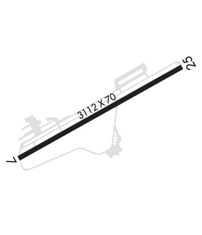
| Lat: N 4058.3 Long: W 07459.9 Elev: 372 Var: +13 Longest Runway: 3112 | ||
| CTAF: 123.0 | ||
| |||||||||||||||||||||||||||||||||||||||||||||||||||||||||||||
| |||||||||||||||||||||||||||||||||||||||||||||||||||||||||||||
| Rwy | Rwy | |||||||
| 3112x70 | 2794' | 3112x70 | 2877' | |||||
| Runway ID | Single Wheel | Double Wheel | Double Tandem Wheel | Dual Double Wheel |
| 07/25 | N/A | N/A | N/A | N/A |
| These numbers are Advisory and are not limits. The Airport Manager should have more accurate Weight Limits | ||||
 Airport Diagram might not be current. | |
| Facility Name: | BLAIRSTOWN |
| City Name: | BLAIRSTOWN |
| County: | WARREN |
| State abbrev: | NJ |
| State Name: | NEW JERSEY |
| Ownership: | PRIVATELY OWNED |
| Use: | OPEN TO THE PUBLIC |
| Owner's Name: | J.D. AIR INC. |
| Address: | 17-68 RIVER ROAD |
| FAIRLAWN, NJ 07410 | |
| Owner's Phone: | 201-796-1556 |
| Manager's Name: | DENNIS KIERNAN |
| Address: | 36 LAMBERT RD. |
| BLAIRSTOWN, NJ 07825 | |
| Phone: | 908-362-8965 |
| FAA Region: | EASTERN |
| FAA Field Office: | HAR |
| Date | Sunrise | Sunset |
|---|---|---|
| 04/25/24 Thursday | 6:05 | 19:51 |
| 04/26/24 Friday | 6:04 | 19:52 |
| 04/27/24 Saturday | 6:02 | 19:53 |
| 04/28/24 Sunday | 6:01 | 19:54 |
| 04/29/24 Monday | 6:00 | 19:55 |
| 04/30/24 Tuesday | 5:58 | 19:56 |
| 05/01/24 Wednesday | 5:57 | 19:57 |
| 05/02/24 Thursday | 5:56 | 19:59 |
| 05/03/24 Friday | 5:55 | 20:00 |
| 05/04/24 Saturday | 5:53 | 20:01 |
| 05/05/24 Sunday | 5:52 | 20:02 |
| 05/06/24 Monday | 5:51 | 20:03 |
| 05/07/24 Tuesday | 5:50 | 20:04 |
| 05/08/24 Wednesday | 5:49 | 20:05 |
| Airport Attendance Schedule | 7 Days A Week 0700-1800 |
| Airport Status | OPERATIONAL (This Status can change at any time - please check NOTAMS) |
| Airport Lighting Schedule | ACTVT MIRL RY 07/25-CTAF. |
| Airport Storage Available | Tie Downs |
| Extra Services Available | Glider, Flight Instruction, Glider Towing |
| Wind Indicator | YES - (lighted) |
| Control Tower | NO |
| CTAF Frequency | 123.000 |
| Unicom Frequency | 123.000 |
| Rotating Beacon Color | WG |
| Segmented Circle | NO |
| Landing Fee | NO |
| Airport Inspected | STATE - performed by STATE AERONAUTICAL PERSONNEL |
| Inspection Date | 05/17/2023 |
| Type of Fuel Available | Grade 100LL; -1024 HOUR SELF SERVICE |
| Airframe Repair Service | MAJOR |
| Power Plant Repair Service | MAJOR |
| Latitude | N4058.3 |
| Longitude | W07459.9 (ESTIMATED) |
| Arpt Elevation | 371ft (SURVEYED) |
| Magnetic Variation | 13W |
| 2 miles SW | of BLAIRSTOWN |
| Traffic Pattern Altitude | |
| Sectional Chart | NEW YORK |
| Operations (Reported) | Yearly | Avg. Daily |
|---|---|---|
| General Aviation Transient | 7916 | 22 |
| General Aviation Local | 12225 | 33 |
| Air Taxi | 0 | 0 |
| Commerical | 0 | 0 |
| Commuter | 0 | 0 |
| Military | 0 | 0 |
| Aircraft based on Field | |
|---|---|
| General Aviation Singles | 80 |
| General Aviation Multi | 5 |
| Jet Aircraft | 0 |
| General Aviation Helicopters | 3 |
| Military Aircraft | 0 |
| Gliders | 48 |
| Ultralights | 0 |
| FSS on field | NO |
| FSS tie-in | MILLVILLE |
| FSS Phone | 1-800-WX-BRIEF |
| Who issues Notams | MIV |
| Notam D service at airport | YES |
| ARTCC Name | NEW YORK |
| Airport Certification | |
| Aircraft Rescue & Firefighting Index | None |
| Airport of Entry | No |
| Custom Landing Rights | No |
| Joint Civil/Military | No |
| Military Landing rights | No |
| GLIDERS & TOW AIRPLANES OPERATE FM TURF AREA JUST SOUTH OF RY 07/25. |
| TREES IN THE 7:1 TRANSITIONAL AREA ALONG RUNWAY SIDES. |
| HILL EAST OF ARPT MAY REQUIRE PILOTS TO EXECUTE STEEP APCH TO RY 25. |
| FOR CD CTC ALLENTOWN APCH AT 800-728-6322. |
Airport Communications & Frequencies:
| |||||||||||||||||||||||||
| Runway: 07 | Runway: 25 | ||
| Mag heading: | 74° | Mag heading: | 254° |
| Rwy Slope: | .17% Up | Rwy Slope: | -.17% Down |
| Approach: | Approach: | ||
| Pattern: | Left Traffic | Pattern: | Left Traffic |
| Markings: | NONPRECISION INSTRUMENT | Markings: | NONPRECISION INSTRUMENT |
| Marking Condition: | GOOD | Marking Condition: | GOOD |
| Arresting Dev: | Arresting Dev: | ||
| Lat & Long: | N4058.1 W07500.1 | Lat. & Long.: | N4058.4 W07459.6 |
| Elev: | 366.2 ft. MSL | Elev: | 371.5 ft. MSL |
| TCH: | TCH: | ||
| Visual Glide Path: | Visual Glide Path: | ||
| Displaced Threshold: | 318 feet | Displaced Threshold: | 235 feet |
| Touchdown Zone: | YES | Touchdown Zone: | YES |
| Touchdown Elev.: | 371.5 feet | Touchdown Elev.: | 370.9 feet |
| Visual Glide Slope: | Visual Glide Slope: | ||
| RVR Equipment: | RVR Equipment: | ||
| RVV Equipment: | NO | RVV Equipment: | NO |
| Approach Lights: | Approach Lights: | ||
| REIL: | NO | REIL: | NO |
| Centerline Lights: | NO | Centerline Lights: | NO |
| Touchdown lights: | NO | Touchdown lights: | NO |
| Runway Category: | Runway with a Non-precision Approach | Runway Category: | Runway with a Non-precision Approach |
| Declared Distances: | Declared Distances: | ||
| Obstructions: | TREES | Obstructions: | TREES |
| Marked: | NOT Marked/Lighted | Marked: | NOT Marked/Lighted |
| Clearance slope: | RY 07 APCH RATIO 2:1 TO THE DSPLCD THLD. | Clearance slope: | RY 25 APCH RATIO 0:1 TO THE DSPLCD THLD. |
| Obstruction height: | 77 feet AGL | Obstruction height: | 25 feet AGL |
| Dist. from runway: | 225 feet | Dist. from runway: | 207 feet |
| Centerline offset: | 198 right of centerline | Centerline offset: | 31 feet right of centerline |
| Comments: | +95 FT TREE, 4 FT FROM RY END, 225 FT L | Comments: | +33FT TREE, 23 FT FM RWY END, 145 FT R |
Thanks for using FltPlan.com
all rights reserved © 1999-2024 by Flight Plan LLC