
| LAKE BARKLEY STATE PARK CADIZ KY |
| |
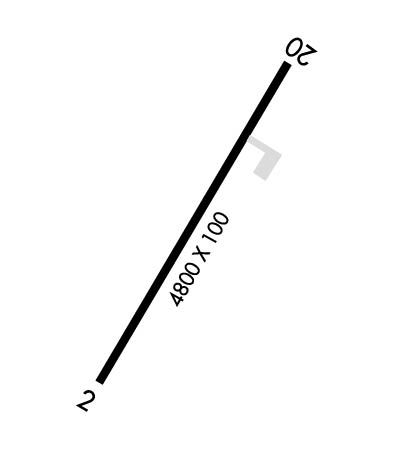
| Lat: N 3649.1 Long: W 08754.5 Elev: 571 Var: -00 Longest Runway: 4800 | ||
| AWOS: 119.02 CTAF: 123.0 | ||
| ||||||||||||||||||||||||||||||||
| ||||||||||||||||||||||||||||||||
| ||||||||||||||||||||||||||||||||
| Rwy | Rwy | |||||||
| 4800x75 | 4800' | 4800x75 | 4800' | |||||
| Runway ID | Single Wheel | Double Wheel | Double Tandem Wheel | Dual Double Wheel |
| 02/20 | 30,000 | N/A | N/A | N/A |
| These numbers are Advisory and are not limits. The Airport Manager should have more accurate Weight Limits | ||||
| FltPlan does not have IFR approach charts available for K1M9. |
 Airport Diagram might not be current. | |
| Facility Name: | LAKE BARKLEY STATE PARK |
| City Name: | CADIZ |
| County: | TRIGG |
| State abbrev: | KY |
| State Name: | KENTUCKY |
| Ownership: | PUBLICLY OWNED |
| Use: | OPEN TO THE PUBLIC |
| Owner's Name: | KY DEPT OF PARKS |
| Address: | 2 HUDSON HOLLOW UNIT 1 |
| FRANKFORT, KY 40601 | |
| Owner's Phone: | (502) 892-3367 |
| Manager's Name: | ASHLEY JOINER |
| Address: | 3500 STATE PARK ROAD |
| CADIZ, KY 42211 | |
| Phone: | 270-924-1131 |
| FAA Region: | SOUTHERN |
| FAA Field Office: | MEM |
| Date | Sunrise | Sunset |
|---|---|---|
| 04/25/24 Thursday | 6:04 | 19:36 |
| 04/26/24 Friday | 6:03 | 19:37 |
| 04/27/24 Saturday | 6:01 | 19:37 |
| 04/28/24 Sunday | 6:00 | 19:38 |
| 04/29/24 Monday | 5:59 | 19:39 |
| 04/30/24 Tuesday | 5:58 | 19:40 |
| 05/01/24 Wednesday | 5:57 | 19:41 |
| 05/02/24 Thursday | 5:56 | 19:42 |
| 05/03/24 Friday | 5:55 | 19:43 |
| 05/04/24 Saturday | 5:54 | 19:44 |
| 05/05/24 Sunday | 5:53 | 19:45 |
| 05/06/24 Monday | 5:51 | 19:45 |
| 05/07/24 Tuesday | 5:50 | 19:46 |
| 05/08/24 Wednesday | 5:50 | 19:47 |
| Airport Attendance Schedule | UNATTENDED |
| Airport Status | OPERATIONAL (This Status can change at any time - please check NOTAMS) |
| Airport Lighting Schedule | ACTVT REIL RWY 02 & 20; PAPI RWY 20; MIRL RWY 02/20 - CTAF. |
| Airport Storage Available | Tie Downs |
| Extra Services Available | NONE |
| Wind Indicator | YES - (lighted) |
| Control Tower | NO |
| CTAF Frequency | 123.000 |
| Unicom Frequency | 123.000 |
| Rotating Beacon Color | WG |
| Segmented Circle | YES |
| Landing Fee | NO |
| Airport Inspected | STATE - performed by STATE AERONAUTICAL PERSONNEL |
| Inspection Date | 10/17/2019 |
| Type of Fuel Available | None |
| Airframe Repair Service | None |
| Power Plant Repair Service | None |
| Latitude | N3649.1 |
| Longitude | W08754.5 (ESTIMATED) |
| Arpt Elevation | 570ft (SURVEYED) |
| Magnetic Variation | 00E |
| 4 miles SW | of CADIZ |
| Traffic Pattern Altitude | |
| Sectional Chart | ST LOUIS |
| Operations (Reported) | Yearly | Avg. Daily |
|---|---|---|
| General Aviation Transient | 5500 | 15 |
| General Aviation Local | 1500 | 4 |
| Air Taxi | 200 | 1 |
| Commerical | 0 | 0 |
| Commuter | 0 | 0 |
| Military | 7500 | 21 |
| Aircraft based on Field | |
|---|---|
| General Aviation Singles | 0 |
| General Aviation Multi | 0 |
| Jet Aircraft | 0 |
| General Aviation Helicopters | 0 |
| Military Aircraft | 0 |
| Gliders | 0 |
| Ultralights | 0 |
| FSS on field | NO |
| FSS tie-in | LOUISVILLE |
| FSS Phone | 1-800-WX-BRIEF |
| Who issues Notams | LOU |
| Notam D service at airport | YES |
| ARTCC Name | MEMPHIS |
| Airport Certification | |
| Aircraft Rescue & Firefighting Index | None |
| Airport of Entry | No |
| Custom Landing Rights | No |
| Joint Civil/Military | No |
| Military Landing rights | No |
| NATIONAL PLAN OF INTEGRATED AIRPORT SYSTEMS (NPIAS) |
| PARK LODGE T/R - 270-924-1131 |
| DEER & BIRDS ON & INVOF ARPT. |
| FOR CD CTC CAMPBELL APCH AT 270-798-6441. |
| Runway: 02 | Runway: 20 | ||
| Mag heading: | N/A | Mag heading: | N/A |
| Rwy Slope: | .46% Up | Rwy Slope: | -.46% Down |
| Approach: | Approach: | ||
| Pattern: | Left Traffic | Pattern: | Left Traffic |
| Markings: | NONPRECISION INSTRUMENT | Markings: | NONPRECISION INSTRUMENT |
| Marking Condition: | POOR; FADED & ALGAE COVD. | Marking Condition: | POOR; FADED & ALGAE COVD. |
| Arresting Dev: | Arresting Dev: | ||
| Lat & Long: | N3648.7 W08754.6 | Lat. & Long.: | N3649.4 W08754.3 |
| Elev: | 549.0 ft. MSL | Elev: | 570.9 ft. MSL |
| TCH: | TCH: | 38 ft. AGL | |
| Visual Glide Path: | Visual Glide Path: | 4.00 degrees | |
| Displaced Threshold: | No | Displaced Threshold: | No |
| Touchdown Zone: | YES | Touchdown Zone: | YES |
| Touchdown Elev.: | 570.9 feet | Touchdown Elev.: | 570.9 feet |
| Visual Glide Slope: | Visual Glide Slope: | 2-Light PAPI on LEFT side of Runway | |
| RVR Equipment: | RVR Equipment: | ||
| RVV Equipment: | NO | RVV Equipment: | NO |
| Approach Lights: | Approach Lights: | ||
| REIL: | YES | REIL: | YES |
| Centerline Lights: | NO | Centerline Lights: | NO |
| Touchdown lights: | NO | Touchdown lights: | NO |
| Runway Category: | Runway with a Visual Approach | Runway Category: | Runway with a Visual Approach |
| Declared Distances: | TORA:4800' TODA:4800' ASDA:4700' LDA:4600' | Declared Distances: | TORA:4800' TODA:4800' ASDA:4700' LDA:4600' |
| Obstructions: | TREES | Obstructions: | TREES |
| Marked: | NOT Marked/Lighted | Marked: | NOT Marked/Lighted |
| Clearance slope: | Clearance slope: | ||
| Obstruction height: | 11 feet AGL | Obstruction height: | 6 feet AGL |
| Dist. from runway: | 200 feet | Dist. from runway: | 200 feet |
| Centerline offset: | 35 right of centerline | Centerline offset: | 162 feet right of centerline |
| Comments: | TREES 150 FT L OF RWY END. | Comments: | TREES 155 FT R OF RWY END. |
Thanks for using FltPlan.com
all rights reserved © 1999-2024 by Flight Plan LLC
