
| SHELBY COMMUNITY SHELBY OH |
| |
| Lat: N 4052.4 Long: W 08241.8 Elev: 1120 Var: +06 Longest Runway: 3174 | ||
| CTAF: 122.8 | ||
| ||||||||||||||||||||||||||||||||
| ||||||||||||||||||||||||||||||||
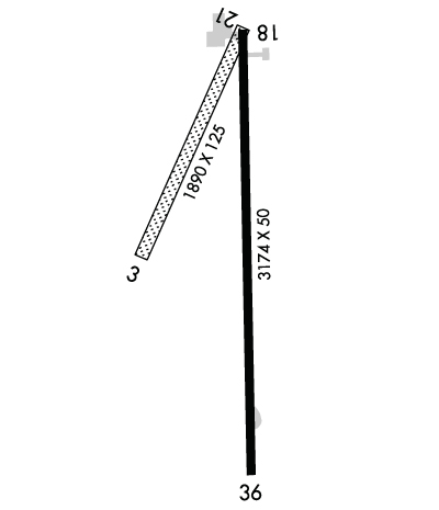
| Rwy | Rwy | |||||||
| 1890x125 | 1890' | 1890x125 | 1890' | |||||
| 3174x50 | 3174' | 3174x50 | 3174' | |||||
| Runway ID | Single Wheel | Double Wheel | Double Tandem Wheel | Dual Double Wheel |
| 03/21 | N/A | N/A | N/A | N/A |
| 18/36 | 5,000 | N/A | N/A | N/A |
| These numbers are Advisory and are not limits. The Airport Manager should have more accurate Weight Limits | ||||
 Airport Diagram might not be current. | |
| Facility Name: | SHELBY COMMUNITY |
| City Name: | SHELBY |
| County: | RICHLAND |
| State abbrev: | OH |
| State Name: | OHIO |
| Ownership: | PRIVATELY OWNED |
| Use: | OPEN TO THE PUBLIC |
| Owner's Name: | SHELBY AIRPORT LLC |
| Address: | PO BOX 29 |
| SHELBY, OH 44875-0029 | |
| Owner's Phone: | 419-347-1185 |
| Manager's Name: | DOUG SCHMIDT |
| Address: | 5085 STATE ROUTE 39 W |
| SHELBY, OH 44875-9061 | |
| Phone: | 419-347-1185; HOME 419-347-8543. |
| FAA Region: | GREAT LAKES |
| FAA Field Office: | DET |
| Date | Sunrise | Sunset |
|---|---|---|
| 04/25/24 Thursday | 6:36 | 20:22 |
| 04/26/24 Friday | 6:35 | 20:23 |
| 04/27/24 Saturday | 6:33 | 20:24 |
| 04/28/24 Sunday | 6:32 | 20:25 |
| 04/29/24 Monday | 6:31 | 20:26 |
| 04/30/24 Tuesday | 6:29 | 20:27 |
| 05/01/24 Wednesday | 6:28 | 20:28 |
| 05/02/24 Thursday | 6:27 | 20:29 |
| 05/03/24 Friday | 6:26 | 20:30 |
| 05/04/24 Saturday | 6:24 | 20:31 |
| 05/05/24 Sunday | 6:23 | 20:32 |
| 05/06/24 Monday | 6:22 | 20:33 |
| 05/07/24 Tuesday | 6:21 | 20:34 |
| 05/08/24 Wednesday | 6:20 | 20:35 |
| Airport Attendance Schedule | 7 Days A Week 0600-1700 |
| Airport Status | OPERATIONAL (This Status can change at any time - please check NOTAMS) |
| Airport Lighting Schedule | SS-SR |
| Airport Storage Available | Tie Downs, Hanger |
| Extra Services Available | NONE |
| Wind Indicator | YES - (lighted) |
| Control Tower | NO |
| CTAF Frequency | 122.800 |
| Unicom Frequency | 122.800 |
| Rotating Beacon Color | WG |
| Segmented Circle | NO |
| Landing Fee | NO |
| Airport Inspected | STATE - performed by PRIVATE CONTRACT PERSONNEL |
| Inspection Date | 07/28/2021 |
| Type of Fuel Available | None |
| Airframe Repair Service | None |
| Power Plant Repair Service | None |
| Latitude | N4052.4 |
| Longitude | W08241.8 (ESTIMATED) |
| Arpt Elevation | 1120ft (SURVEYED) |
| Magnetic Variation | 06W |
| 2 miles W | of SHELBY |
| Traffic Pattern Altitude | |
| Sectional Chart | DETROIT |
| Operations (Reported) | Yearly | Avg. Daily |
|---|---|---|
| General Aviation Transient | 500 | 1 |
| General Aviation Local | 1500 | 4 |
| Air Taxi | 12 | 0 |
| Commerical | 0 | 0 |
| Commuter | 0 | 0 |
| Military | 0 | 0 |
| Aircraft based on Field | |
|---|---|
| General Aviation Singles | 11 |
| General Aviation Multi | 0 |
| Jet Aircraft | 0 |
| General Aviation Helicopters | 0 |
| Military Aircraft | 0 |
| Gliders | 0 |
| Ultralights | 1 |
| FSS on field | NO |
| FSS tie-in | CLEVELAND |
| FSS Phone | 1-800-WX-BRIEF |
| Who issues Notams | CLE |
| Notam D service at airport | YES |
| ARTCC Name | CLEVELAND |
| Airport Certification | |
| Aircraft Rescue & Firefighting Index | None |
| Airport of Entry | No |
| Custom Landing Rights | No |
| Joint Civil/Military | No |
| Military Landing rights | No |
| THIS AIRPORT HAS BEEN SURVEYED BY THE NATIONAL GEODETIC SURVEY. |
| FOR CD CTC CLEVELAND APCH AT 216-352-2323, WHEN APCH CLSD CTC CLEVELAND ARTCC AT 440-774-0223. |
| RWY 18/36: 35 FT PLINE, 975 FT NORTH OF RWY END 18, NOT MKD; 95 FT PLINE, 1810 FT SOUTH OF RWY END 36, NOT MKD. |
| RWY 18/3 6 NSTD LIRL DUE TO RWY 18 THR LGTS 220 FT FM RWY END; RWY LGTS 62 FT FM EAST EDGE & 47 FT FM WEST EDGE. |
Airport Communications & Frequencies:
| |||||||||||||||||
| Runway: 03 | Runway: 21 | ||
| Mag heading: | 31° | Mag heading: | 211° |
| Rwy Slope: | -.11% Down | Rwy Slope: | .11% Up |
| Approach: | Approach: | ||
| Pattern: | Left Traffic | Pattern: | Left Traffic |
| Markings: | NONE | Markings: | NONE |
| Marking Condition: | Marking Condition: | ||
| Arresting Dev: | Arresting Dev: | ||
| Lat & Long: | N4052.3 W08242.0 | Lat. & Long.: | N4052.6 W08241.8 |
| Elev: | 1120.4 ft. MSL | Elev: | 1118.3 ft. MSL |
| TCH: | TCH: | ||
| Visual Glide Path: | Visual Glide Path: | ||
| Displaced Threshold: | No | Displaced Threshold: | No |
| Touchdown Zone: | YES | Touchdown Zone: | YES |
| Touchdown Elev.: | 1120.4 feet | Touchdown Elev.: | 1120.4 feet |
| Visual Glide Slope: | Visual Glide Slope: | ||
| RVR Equipment: | RVR Equipment: | ||
| RVV Equipment: | NO | RVV Equipment: | NO |
| Approach Lights: | Approach Lights: | ||
| REIL: | NO | REIL: | NO |
| Centerline Lights: | NO | Centerline Lights: | NO |
| Touchdown lights: | NO | Touchdown lights: | NO |
| Runway Category: | Runway with a Visual Approach | Runway Category: | Runway with a Visual Approach |
| Declared Distances: | Declared Distances: | ||
| Obstructions: | TREE | Obstructions: | BLDG |
| Marked: | NOT Marked/Lighted | Marked: | NOT Marked/Lighted |
| Clearance slope: | 4:1 | Clearance slope: | 10:1 |
| Obstruction height: | 75 feet AGL | Obstruction height: | 42 feet AGL |
| Dist. from runway: | 345 feet | Dist. from runway: | 427 feet |
| Centerline offset: | 70 left of centerline | Centerline offset: | 68 feet left of centerline |
| Comments: | Comments: |
| Runway: 18 | Runway: 36 | ||
| Mag heading: | 185° | Mag heading: | 5° |
| Rwy Slope: | .06% Up | Rwy Slope: | -.06% Down |
| Approach: | Approach: | ||
| Pattern: | Left Traffic | Pattern: | Left Traffic |
| Markings: | BASIC | Markings: | BASIC |
| Marking Condition: | GOOD | Marking Condition: | GOOD |
| Arresting Dev: | Arresting Dev: | ||
| Lat & Long: | N4052.6 W08241.8 | Lat. & Long.: | N4052.1 W08241.8 |
| Elev: | 1117.5 ft. MSL | Elev: | 1119.4 ft. MSL |
| TCH: | TCH: | ||
| Visual Glide Path: | Visual Glide Path: | ||
| Displaced Threshold: | No | Displaced Threshold: | No |
| Touchdown Zone: | YES | Touchdown Zone: | YES |
| Touchdown Elev.: | 1119.1 feet | Touchdown Elev.: | 1119.5 feet |
| Visual Glide Slope: | Visual Glide Slope: | ||
| RVR Equipment: | RVR Equipment: | ||
| RVV Equipment: | NO | RVV Equipment: | NO |
| Approach Lights: | Approach Lights: | ||
| REIL: | NO | REIL: | NO |
| Centerline Lights: | NO | Centerline Lights: | NO |
| Touchdown lights: | NO | Touchdown lights: | NO |
| Runway Category: | Runway with a Visual Approach | Runway Category: | Runway with a Visual Approach |
| Declared Distances: | Declared Distances: | ||
| Obstructions: | ROAD | Obstructions: | PLINE |
| Marked: | NOT Marked/Lighted | Marked: | NOT Marked/Lighted |
| Clearance slope: | Clearance slope: | 17:1 | |
| Obstruction height: | 15 feet AGL | Obstruction height: | 94 feet AGL |
| Dist. from runway: | 201 feet | Dist. from runway: | 1810 feet |
| Centerline offset: | Centerline offset: | 289 feet left of centerline | |
| Comments: | ROAD 165'FM RWY END 125'R. | Comments: | SEASONAL CROPS 75 FT L/R, UP TO 10 FT. |
Thanks for using FltPlan.com
all rights reserved © 1999-2024 by Flight Plan LLC
