
| HARFORD COUNTY CHURCHVILLE MD |
| |
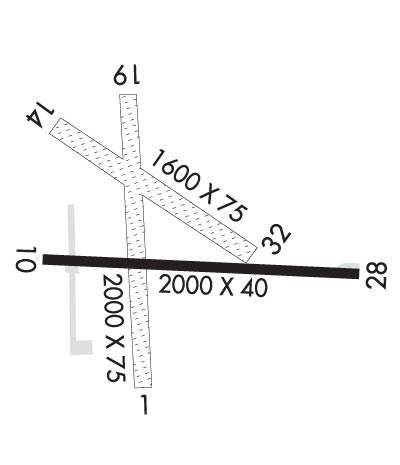
| Lat: N 3934.1 Long: W 07612.2 Elev: 412 Var: +11 Longest Runway: 2850 | ||
| CTAF: 122.8 | ||
| |||||||||||||||||||||||||||||||||||||||||||||||||||||||||||||
| |||||||||||||||||||||||||||||||||||||||||||||||||||||||||||||
| Rwy | Rwy | |||||||
| 2850x75 | 2850' | 2850x75 | 2690' | |||||
| 2015x40 | 2015' | 2015x40 | 1914' | |||||
| Runway ID | Single Wheel | Double Wheel | Double Tandem Wheel | Dual Double Wheel |
| 01/19 | N/A | N/A | N/A | N/A |
| 10/28 | N/A | N/A | N/A | N/A |
| These numbers are Advisory and are not limits. The Airport Manager should have more accurate Weight Limits | ||||
 Airport Diagram might not be current. | |
| Facility Name: | HARFORD COUNTY |
| City Name: | CHURCHVILLE |
| County: | HARFORD |
| State abbrev: | MD |
| State Name: | MARYLAND |
| Ownership: | PRIVATELY OWNED |
| Use: | OPEN TO THE PUBLIC |
| Owner's Name: | HARFORD CTY ARPT OWNERS GROUP INC |
| Address: | 3538-H9 ALDINO ROAD |
| CHURCHVILLE, MD 21028 | |
| Owner's Phone: | 410-836-2828 |
| Manager's Name: | KEVIN HESS |
| Address: | 3538-H9 ALDINO RD |
| CHURCHVILLE, MD 21028 | |
| Phone: | 410-836-2828 |
| FAA Region: | EASTERN |
| FAA Field Office: | DCA |

| Date | Sunrise | Sunset |
|---|---|---|
| 04/25/24 Thursday | 6:12 | 19:53 |
| 04/26/24 Friday | 6:11 | 19:54 |
| 04/27/24 Saturday | 6:10 | 19:55 |
| 04/28/24 Sunday | 6:09 | 19:56 |
| 04/29/24 Monday | 6:07 | 19:57 |
| 04/30/24 Tuesday | 6:06 | 19:58 |
| 05/01/24 Wednesday | 6:05 | 19:59 |
| 05/02/24 Thursday | 6:04 | 20:00 |
| 05/03/24 Friday | 6:02 | 20:01 |
| 05/04/24 Saturday | 6:01 | 20:02 |
| 05/05/24 Sunday | 6:00 | 20:03 |
| 05/06/24 Monday | 5:59 | 20:04 |
| 05/07/24 Tuesday | 5:58 | 20:05 |
| 05/08/24 Wednesday | 5:57 | 20:06 |
| Airport Attendance Schedule | 7 Days A Week 1300Z++-DUSK |
| Airport Status | OPERATIONAL (This Status can change at any time - please check NOTAMS) |
| Airport Lighting Schedule | ACTVT REIL RWY 01 & 19; PAPI RWY 01 & 19; MIRL RWY 01/19 - CTAF.; DUSK-0100. |
| Airport Storage Available | Tie Downs |
| Extra Services Available | Glider, Flight Instruction, Parachute Jumping, Aircraft Rental, Glider Towing |
| Wind Indicator | YES - (lighted) |
| Control Tower | NO |
| CTAF Frequency | 122.800 |
| Unicom Frequency | 122.800 |
| Rotating Beacon Color | WG |
| Segmented Circle | NO |
| Landing Fee | NO |
| Airport Inspected | STATE - performed by STATE AERONAUTICAL PERSONNEL |
| Inspection Date | 03/12/2024 |
| Type of Fuel Available | Grade 100LL, JET A (freeze point -40C) |
| Airframe Repair Service | MAJOR |
| Power Plant Repair Service | MAJOR |
| Latitude | N3934.1 |
| Longitude | W07612.2 (ESTIMATED) |
| Arpt Elevation | 411ft (SURVEYED) |
| Magnetic Variation | 11W |
| 3 miles E | of CHURCHVILLE |
| Traffic Pattern Altitude | |
| Sectional Chart | WASHINGTON |
| Operations (Reported) | Yearly | Avg. Daily |
|---|---|---|
| General Aviation Transient | 2000 | 5 |
| General Aviation Local | 11000 | 30 |
| Air Taxi | 10 | 0 |
| Commerical | 0 | 0 |
| Commuter | 0 | 0 |
| Military | 200 | 1 |
| Aircraft based on Field | |
|---|---|
| General Aviation Singles | 69 |
| General Aviation Multi | 0 |
| Jet Aircraft | 1 |
| General Aviation Helicopters | 3 |
| Military Aircraft | 0 |
| Gliders | 0 |
| Ultralights | 0 |
| FSS on field | NO |
| FSS tie-in | LEESBURG |
| FSS Phone | 1-800-WX-BRIEF |
| Who issues Notams | DCA |
| Notam D service at airport | YES |
| ARTCC Name | NEW YORK |
| Airport Certification | |
| Aircraft Rescue & Firefighting Index | None |
| Airport of Entry | No |
| Custom Landing Rights | No |
| Joint Civil/Military | No |
| Military Landing rights | No |
| BIRDS/WILDLIFE ON & INVOF ARPT. |
| FOR CD CTC POTOMAC APCH AT 866-429-5882. |
| CTN PAJA AND GLDR OPS ON ARPT. |
| RWY 10/2 8 PPR FOR RWY 10/28. |
| RWY 10/2 8 RWY 10/28 LIRL NSTD; NO DSPLCD THR LGTS. |
Airport Communications & Frequencies:
| ||||||||||||||
| Runway: 01 | Runway: 19 | ||
| Mag heading: | 8° | Mag heading: | 188° |
| Rwy Slope: | .27% Up | Rwy Slope: | -.27% Down |
| Approach: | Approach: | ||
| Pattern: | Left Traffic | Pattern: | Left Traffic |
| Markings: | NONPRECISION INSTRUMENT | Markings: | NONPRECISION INSTRUMENT |
| Marking Condition: | GOOD | Marking Condition: | GOOD |
| Arresting Dev: | Arresting Dev: | ||
| Lat & Long: | N3933.9 W07612.2 | Lat. & Long.: | N3934.4 W07612.3 |
| Elev: | 403.9 ft. MSL | Elev: | 411.5 ft. MSL |
| TCH: | 26 ft. AGL | TCH: | 42 ft. AGL |
| Visual Glide Path: | 3.50 degrees | Visual Glide Path: | 3.25 degrees |
| Displaced Threshold: | No | Displaced Threshold: | 160 feet |
| Touchdown Zone: | YES | Touchdown Zone: | YES |
| Touchdown Elev.: | 411.5 feet | Touchdown Elev.: | 409.9 feet |
| Visual Glide Slope: | 2-Light PAPI on LEFT side of Runway | Visual Glide Slope: | 2-Light PAPI on LEFT side of Runway |
| RVR Equipment: | RVR Equipment: | ||
| RVV Equipment: | NO | RVV Equipment: | NO |
| Approach Lights: | Approach Lights: | ||
| REIL: | YES | REIL: | YES |
| Centerline Lights: | NO | Centerline Lights: | NO |
| Touchdown lights: | NO | Touchdown lights: | NO |
| Runway Category: | Runway with a Visual Approach | Runway Category: | Runway with a Visual Approach |
| Declared Distances: | Declared Distances: | ||
| Obstructions: | Obstructions: | TREES | |
| Marked: | Marked: | MARKED | |
| Clearance slope: | 20:1 | Clearance slope: | 10:1 |
| Obstruction height: | Obstruction height: | 143 feet AGL | |
| Dist. from runway: | Dist. from runway: | 1724 feet | |
| Centerline offset: | Centerline offset: | 243 feet left of centerline | |
| Comments: | Comments: |
| Runway: 10 | Runway: 28 | ||
| Mag heading: | 104° | Mag heading: | 284° |
| Rwy Slope: | -1.37% Down | Rwy Slope: | 1.37% Up |
| Approach: | Approach: | ||
| Pattern: | Left Traffic | Pattern: | Left Traffic |
| Markings: | NONPRECISION INSTRUMENT | Markings: | BASIC |
| Marking Condition: | FAIR | Marking Condition: | FAIR |
| Arresting Dev: | Arresting Dev: | ||
| Lat & Long: | N3934.0 W07612.3 | Lat. & Long.: | N3934.0 W07611.9 |
| Elev: | 407.6 ft. MSL | Elev: | 379.9 ft. MSL |
| TCH: | TCH: | ||
| Visual Glide Path: | Visual Glide Path: | ||
| Displaced Threshold: | No | Displaced Threshold: | 101 feet |
| Touchdown Zone: | YES | Touchdown Zone: | YES |
| Touchdown Elev.: | 407.6 feet | Touchdown Elev.: | 407.6 feet |
| Visual Glide Slope: | Visual Glide Slope: | ||
| RVR Equipment: | RVR Equipment: | ||
| RVV Equipment: | NO | RVV Equipment: | NO |
| Approach Lights: | Approach Lights: | ||
| REIL: | YES | REIL: | YES |
| Centerline Lights: | NO | Centerline Lights: | NO |
| Touchdown lights: | NO | Touchdown lights: | NO |
| Runway Category: | Runway with a Visual Approach | Runway Category: | Runway with a Visual Approach |
| Declared Distances: | Declared Distances: | ||
| Obstructions: | TREES | Obstructions: | TREES |
| Marked: | NOT Marked/Lighted | Marked: | NOT Marked/Lighted |
| Clearance slope: | 12:1 | Clearance slope: | 3:1; RWY 28 APCH RATIO 11:1 TO DSPLCD THR AT CNTRLN. |
| Obstruction height: | 86 feet AGL | Obstruction height: | 73 feet AGL |
| Dist. from runway: | 1299 feet | Dist. from runway: | 459 feet |
| Centerline offset: | 23 left of centerline | Centerline offset: | 123 feet left of centerline |
| Comments: | Comments: | 17 FT TREES 122 FT OUT, 11 FT LEFT. |
Thanks for using FltPlan.com
all rights reserved © 1999-2024 by Flight Plan LLC
