
| REELFOOT LAKE TIPTONVILLE TN |
| |
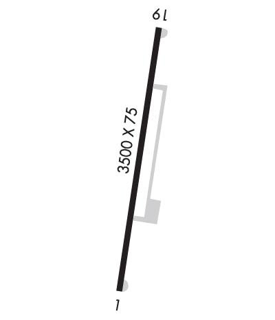
| Lat: N 3628.5 Long: W 08920.8 Elev: 289 Var: -02 Longest Runway: 3500 | ||
| CTAF: 122.9 | ||
| ||||||||||||||||||||||||||||||||
| ||||||||||||||||||||||||||||||||
| Rwy | Rwy | |||||||
| 3500x75 | 3500' | 3500x75 | 3500' | |||||
| Runway ID | Single Wheel | Double Wheel | Double Tandem Wheel | Dual Double Wheel |
| 01/19 | 25,000 | 37,000 | N/A | N/A |
| These numbers are Advisory and are not limits. The Airport Manager should have more accurate Weight Limits | ||||
| FltPlan does not have IFR approach charts available for K0M2. |
 Airport Diagram might not be current. | |
| Facility Name: | REELFOOT LAKE |
| City Name: | TIPTONVILLE |
| County: | LAKE |
| State abbrev: | TN |
| State Name: | TENNESSEE |
| Ownership: | PUBLICLY OWNED |
| Use: | OPEN TO THE PUBLIC |
| Owner's Name: | TDOT OFFICE OF AERONAUTICS |
| Address: | 7335 CENTENNIAL BLVD |
| NASHVILLE, TN 37209 | |
| Owner's Phone: | 615-741-1680 |
| Manager's Name: | BILL BURNEY |
| Address: | 7335 CENTENNIAL BLVD |
| NASHVILLE, TN 37209 | |
| Phone: | 615-741-1680 |
| FAA Region: | SOUTHERN |
| FAA Field Office: | MEM |
| Date | Sunrise | Sunset |
|---|---|---|
| 04/24/24 Wednesday | 6:11 | 19:40 |
| 04/25/24 Thursday | 6:10 | 19:41 |
| 04/26/24 Friday | 6:09 | 19:42 |
| 04/27/24 Saturday | 6:08 | 19:43 |
| 04/28/24 Sunday | 6:07 | 19:44 |
| 04/29/24 Monday | 6:05 | 19:44 |
| 04/30/24 Tuesday | 6:04 | 19:45 |
| 05/01/24 Wednesday | 6:03 | 19:46 |
| 05/02/24 Thursday | 6:02 | 19:47 |
| 05/03/24 Friday | 6:01 | 19:48 |
| 05/04/24 Saturday | 6:00 | 19:49 |
| 05/05/24 Sunday | 5:59 | 19:50 |
| 05/06/24 Monday | 5:58 | 19:50 |
| 05/07/24 Tuesday | 5:57 | 19:51 |
| Airport Attendance Schedule | UNATTENDED |
| Airport Status | OPERATIONAL (This Status can change at any time - please check NOTAMS) |
| Airport Lighting Schedule | |
| Airport Storage Available | Tie Downs |
| Extra Services Available | Crop Dusting |
| Wind Indicator | YES - (unlit) |
| Control Tower | NO |
| CTAF Frequency | 122.900 |
| Unicom Frequency | |
| Rotating Beacon Color | WG; OTS INDEFLY. |
| Segmented Circle | YES |
| Landing Fee | NO |
| Airport Inspected | STATE - performed by STATE AERONAUTICAL PERSONNEL |
| Inspection Date | 03/26/2021 |
| Type of Fuel Available | None |
| Airframe Repair Service | None |
| Power Plant Repair Service | None |
| Latitude | N3628.5 |
| Longitude | W08920.8 (ESTIMATED) |
| Arpt Elevation | 289ft (ESTIMATED) |
| Magnetic Variation | 02E |
| 9 miles NE | of TIPTONVILLE |
| Traffic Pattern Altitude | |
| Sectional Chart | ST LOUIS |
| Operations (Reported) | Yearly | Avg. Daily |
|---|---|---|
| General Aviation Transient | 2500 | 7 |
| General Aviation Local | 6 | 0 |
| Air Taxi | 0 | 0 |
| Commerical | 0 | 0 |
| Commuter | 0 | 0 |
| Military | 300 | 1 |
| Aircraft based on Field | |
|---|---|
| General Aviation Singles | 1 |
| General Aviation Multi | 0 |
| Jet Aircraft | 0 |
| General Aviation Helicopters | 0 |
| Military Aircraft | 0 |
| Gliders | 0 |
| Ultralights | 0 |
| FSS on field | NO |
| FSS tie-in | JACKSON |
| FSS Phone | 1-800-WX-BRIEF |
| Who issues Notams | MKL |
| Notam D service at airport | YES |
| ARTCC Name | MEMPHIS |
| Airport Certification | |
| Aircraft Rescue & Firefighting Index | None |
| Airport of Entry | No |
| Custom Landing Rights | No |
| Joint Civil/Military | No |
| Military Landing rights | YES |
| ASSURANCES PURSUANT TO TITLE VI, CIVIL RIGHTS ACT OF 1964 |
| GRANT AGREEMENT HAS EXPIRED; HOWEVER, AGREEMENT REMAINS IN EFFECT FOR THIS FACILITY AS LONG AS IT IS PUBLIC USE. |
| MNTN 2000 FT OVR LAKE E OF ARPT. |
| FOR CD CTC MEMPHIS ARTCC AT 901-368-8453/8449. |
| Runway: 01 | Runway: 19 | ||
| Mag heading: | 5° | Mag heading: | 185° |
| Rwy Slope: | .03% Up | Rwy Slope: | -.03% Down |
| Approach: | Approach: | ||
| Pattern: | Left Traffic | Pattern: | Right Traffic |
| Markings: | BASIC | Markings: | BASIC |
| Marking Condition: | FAIR | Marking Condition: | FAIR |
| Arresting Dev: | Arresting Dev: | ||
| Lat & Long: | N3628.2 W08920.8 | Lat. & Long.: | N3628.8 W08920.7 |
| Elev: | 287.0 ft. MSL | Elev: | 288.0 ft. MSL |
| TCH: | TCH: | ||
| Visual Glide Path: | Visual Glide Path: | ||
| Displaced Threshold: | No | Displaced Threshold: | No |
| Touchdown Zone: | NO | Touchdown Zone: | NO |
| Touchdown Elev.: | Touchdown Elev.: | ||
| Visual Glide Slope: | Visual Glide Slope: | ||
| RVR Equipment: | RVR Equipment: | ||
| RVV Equipment: | NO | RVV Equipment: | NO |
| Approach Lights: | Approach Lights: | ||
| REIL: | NO | REIL: | NO |
| Centerline Lights: | NO | Centerline Lights: | NO |
| Touchdown lights: | NO | Touchdown lights: | NO |
| Runway Category: | Runway with a Visual Approach | Runway Category: | Runway with a Visual Approach |
| Declared Distances: | Declared Distances: | ||
| Obstructions: | TREES | Obstructions: | FENCE |
| Marked: | NOT Marked/Lighted | Marked: | NOT Marked/Lighted |
| Clearance slope: | 12:1 | Clearance slope: | 18:1 |
| Obstruction height: | 60 feet AGL | Obstruction height: | 109 feet AGL |
| Dist. from runway: | 950 feet | Dist. from runway: | 2180 feet |
| Centerline offset: | 122 left of centerline | Centerline offset: | 217 feet left of centerline |
| Comments: | Comments: |
Thanks for using FltPlan.com
all rights reserved © 1999-2024 by Flight Plan LLC
