
| BIBB COUNTY CENTREVILLE AL |
| |
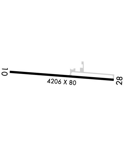
| Lat: N 3256.2 Long: W 08705.4 Elev: 251 Var: +02 Longest Runway: 4206 | ||
| CTAF: 122.97 | ||
| ||||||||||||||||||||||||||||||||
| ||||||||||||||||||||||||||||||||
| Rwy | Rwy | |||||||
| 4206x80 | 4206' | 4206x80 | 4206' | |||||
| Runway ID | Single Wheel | Double Wheel | Double Tandem Wheel | Dual Double Wheel |
| 10/28 | 18,000 | N/A | N/A | N/A |
| These numbers are Advisory and are not limits. The Airport Manager should have more accurate Weight Limits | ||||
 Airport Diagram might not be current. | |
| Facility Name: | BIBB COUNTY |
| City Name: | CENTREVILLE |
| County: | BIBB |
| State abbrev: | AL |
| State Name: | ALABAMA |
| Ownership: | PUBLICLY OWNED |
| Use: | OPEN TO THE PUBLIC |
| Owner's Name: | BIBB COUNTY COMMISSION |
| Address: | 157 SW DAVIDSON DRIVE |
| CENTREVILLE, AL 35042 | |
| Owner's Phone: | (205) 926-3114 |
| Manager's Name: | SHANE WALLACE |
| Address: | P.O BOX 308 |
| CENTREVILLE, AL 35042 | |
| Phone: | 205-247-6001; FOR ARPT ACES CTC 205-225-4763 OR 205-316-8574. |
| FAA Region: | SOUTHERN |
| FAA Field Office: | JAN |
| Date | Sunrise | Sunset |
|---|---|---|
| 04/25/24 Thursday | 6:06 | 19:27 |
| 04/26/24 Friday | 6:05 | 19:27 |
| 04/27/24 Saturday | 6:04 | 19:28 |
| 04/28/24 Sunday | 6:03 | 19:29 |
| 04/29/24 Monday | 6:02 | 19:29 |
| 04/30/24 Tuesday | 6:01 | 19:30 |
| 05/01/24 Wednesday | 6:00 | 19:31 |
| 05/02/24 Thursday | 5:59 | 19:32 |
| 05/03/24 Friday | 5:58 | 19:32 |
| 05/04/24 Saturday | 5:57 | 19:33 |
| 05/05/24 Sunday | 5:56 | 19:34 |
| 05/06/24 Monday | 5:56 | 19:35 |
| 05/07/24 Tuesday | 5:55 | 19:35 |
| 05/08/24 Wednesday | 5:54 | 19:36 |
| Airport Attendance Schedule | UNATTENDED; ARPT UNATNDD. |
| Airport Status | OPERATIONAL (This Status can change at any time - please check NOTAMS) |
| Airport Lighting Schedule | ACTVT REIL RWY 10 & 28; PAPI RWY 10 & 28; MIRL RWY 10/28 - CTAF. |
| Airport Storage Available | NONE |
| Extra Services Available | NONE |
| Wind Indicator | YES - (lighted) |
| Control Tower | NO |
| CTAF Frequency | 122.975 |
| Unicom Frequency | 122.975 |
| Rotating Beacon Color | WG |
| Segmented Circle | NO |
| Landing Fee | NO |
| Airport Inspected | STATE - performed by STATE AERONAUTICAL PERSONNEL |
| Inspection Date | 08/04/2023 |
| Type of Fuel Available | None |
| Airframe Repair Service | NONE |
| Power Plant Repair Service | MINOR |
| Latitude | N3256.2 |
| Longitude | W08705.4 (ESTIMATED) |
| Arpt Elevation | 250ft (SURVEYED) |
| Magnetic Variation | 02W |
| 3 miles E | of CENTREVILLE |
| Traffic Pattern Altitude | |
| Sectional Chart | ATLANTA |
| Operations (Reported) | Yearly | Avg. Daily |
|---|---|---|
| General Aviation Transient | 2750 | 8 |
| General Aviation Local | 792 | 2 |
| Air Taxi | 0 | 0 |
| Commerical | 0 | 0 |
| Commuter | 0 | 0 |
| Military | 0 | 0 |
| Aircraft based on Field | |
|---|---|
| General Aviation Singles | 8 |
| General Aviation Multi | 0 |
| Jet Aircraft | 2 |
| General Aviation Helicopters | 0 |
| Military Aircraft | 0 |
| Gliders | 0 |
| Ultralights | 0 |
| FSS on field | NO |
| FSS tie-in | ANNISTON |
| FSS Phone | 1-800-WX-BRIEF |
| Who issues Notams | ANB |
| Notam D service at airport | YES |
| ARTCC Name | ATLANTA |
| Airport Certification | |
| Aircraft Rescue & Firefighting Index | None |
| Airport of Entry | No |
| Custom Landing Rights | No |
| Joint Civil/Military | No |
| Military Landing rights | No |
| NATIONAL PLAN OF INTEGRATED AIRPORT SYSTEMS (NPIAS) |
| PILOT ACES VIA WALK THRU GATE ON NORTH SIDE OF ARPT. |
| FOR CD CTC ATLANTA ARTCC AT 770-210-7692. |
Airport Communications & Frequencies:
| |||||||||
| Runway: 10 | Runway: 28 | ||
| Mag heading: | 97° | Mag heading: | 277° |
| Rwy Slope: | .29% Up | Rwy Slope: | -.29% Down |
| Approach: | Approach: | ||
| Pattern: | Left Traffic | Pattern: | Left Traffic |
| Markings: | NONPRECISION INSTRUMENT | Markings: | NONPRECISION INSTRUMENT |
| Marking Condition: | GOOD | Marking Condition: | GOOD |
| Arresting Dev: | Arresting Dev: | ||
| Lat & Long: | N3256.2 W08705.8 | Lat. & Long.: | N3256.2 W08705.0 |
| Elev: | 238.5 ft. MSL | Elev: | 250.9 ft. MSL |
| TCH: | 40 ft. AGL | TCH: | 40 ft. AGL |
| Visual Glide Path: | 4.00 degrees | Visual Glide Path: | 4.00 degrees |
| Displaced Threshold: | No | Displaced Threshold: | No |
| Touchdown Zone: | YES | Touchdown Zone: | YES |
| Touchdown Elev.: | 240.4 feet | Touchdown Elev.: | 250.9 feet |
| Visual Glide Slope: | 2-Light PAPI on LEFT side of Runway | Visual Glide Slope: | 2-Light PAPI on LEFT side of Runway |
| RVR Equipment: | RVR Equipment: | ||
| RVV Equipment: | NO | RVV Equipment: | NO |
| Approach Lights: | Approach Lights: | ||
| REIL: | YES | REIL: | YES |
| Centerline Lights: | NO | Centerline Lights: | NO |
| Touchdown lights: | NO | Touchdown lights: | NO |
| Runway Category: | Runway with a Non-precision Approach | Runway Category: | Runway with a Non-precision Approach |
| Declared Distances: | Declared Distances: | ||
| Obstructions: | TREE | Obstructions: | TREES |
| Marked: | NOT Marked/Lighted | Marked: | NOT Marked/Lighted |
| Clearance slope: | 9:1 | Clearance slope: | 1:1 |
| Obstruction height: | 83 feet AGL | Obstruction height: | 66 feet AGL |
| Dist. from runway: | 969 feet | Dist. from runway: | 297 feet |
| Centerline offset: | 356 right of centerline | Centerline offset: | 183 feet left of centerline |
| Comments: | Comments: |
Thanks for using FltPlan.com
all rights reserved © 1999-2024 by Flight Plan LLC
